فائل:GoldenHorde1300.png

ایس وکھالے دا ناپ: ۸۰۰ × ۴۸۱ پکسلز۔ دوجے ریزولوشنز: ۳۲۰ × ۱۹۳ پکسلز | ۶۴۰ × ۳۸۵ پکسلز | ۱,۰۲۴ × ۶۱۶ پکسلز | ۱,۴۳۶ × ۸۶۴ پکسلز ۔
اصل فائل (۱,۴۳۶ × ۸۶۴ پکسلز, فائل حجم: ۴۷ کلوبائٹ, MIME type: image/png)

|
This map image could be re-created using vector graphics as an SVG file. This has several advantages; see Commons:Media for cleanup for more information. If an SVG form of this image is available, please upload it and afterwards replace this template with
{{vector version available|new image name}}.
It is recommended to name the SVG file “GoldenHorde1300.svg”—then the template Vector version available (or Vva) does not need the new image name parameter. |
خلاصہ
| تفصیل |
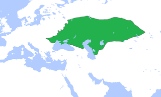
English: Locator map of the Golden Horde, c. 1300.
(Partially based on Atlas of World History (2007) - The World 1200-1300, map) |
| تریخ | |
| سروت | آپݨا کم |
| لکھاری | Gabagool |
لائسنس –
میں، اس کم دے کاپیرائٹ دا مالک، اس کم نوں اس لائسنس دے مطابق چھاپدا واں:
ایس فائل نوں کریٹو کامنز Attribution 3.0 انپورٹڈ لائسنس دتا گیا.
- تہانوں کھلھ اے:
- حصہ کرنا – کاپی، ونڈنا تے کم بھیجنا
- فیر رلانا – کم نوں فٹ کرنا
- تھلے دتیاں شرطاں نال:
- کس دے ناں – تسیں لازمی ایس کم دے بناں والے بارے دسو جنج اونے آکھیا اے یا جنج لسنس چ آکھیا گیا ہے۔
فائل دی تریخ
فائل نو اس ویلے دی حالت وچ ویکھن واسطے تاریخ/ویلے تے کلک کرو۔
| تریخ تے ویلہ | نکی مورت | پاسے | ورتن والا | تیپّݨی کرو | |
|---|---|---|---|---|---|
| موجودہ | ۲۰:۵۸, ۱۶ نومبر ۲۰۲۲ | | ۱,۴۳۶ × ۸۶۴ (۴۷ کلوبائٹ) | Gyalu22 | Reverted to version as of 16:08, 5 June 2009 (UTC) |
| ۲۱:۱۲, ۷ جون ۲۰۲۱ |  | ۱,۴۳۶ × ۸۶۴ (۲۸ کلوبائٹ) | Devlet Geray | Reverted to version as of 11:20, 4 June 2018 (UTC) they paid tribute to the Khan and because of this could trade but there were no independent states in Southern Crimea | |
| ۱۷:۰۴, ۴ جون ۲۰۱۸ |  | ۱,۴۳۶ × ۸۶۴ (۲۸ کلوبائٹ) | Julieta39 | No Golden Horde control on the Southern Crimea (byzantine, later Theodoro principality) | |
| ۱۶:۲۰, ۴ جون ۲۰۱۸ |  | ۱,۴۳۶ × ۸۶۴ (۲۸ کلوبائٹ) | Julieta39 | Shorelines, no modern dam lakes, Hungary and Galicia no ruled by Golden Horde | |
| ۲۱:۰۸, ۵ جون ۲۰۰۹ |  | ۱,۴۳۶ × ۸۶۴ (۴۷ کلوبائٹ) | Gabagool | slightly cropped | |
| ۱۸:۰۰, ۲۵ اپریل ۲۰۰۹ |  | ۱,۶۴۴ × ۹۵۹ (۵۶ کلوبائٹ) | Gabagool | {{Information |Description={{en|1=Locator map of the Golden Horde, c. 1300. (Partially based on ''Atlas of World History'' (2007) - The World 1200-1300, map)}} |Source=Own work by uploader |Author=Gabagool / Jarle Grøhn |Date=2009-04-2 |
فائل دی ورتوں
تھلے دتے گئے 3 صفحے اس فائل نال جُڑدے نیں
فائل ویاپک ورتوں
ایہہ دوجے وکیاں ایس فائل نوں ورتدے نیں –
- af.wikipedia.org تے ورتوں
- ar.wikipedia.org تے ورتوں
- arz.wikipedia.org تے ورتوں
- ast.wikipedia.org تے ورتوں
- azb.wikipedia.org تے ورتوں
- az.wikipedia.org تے ورتوں
- be.wikipedia.org تے ورتوں
- bs.wikipedia.org تے ورتوں
- ca.wikipedia.org تے ورتوں
- cs.wikipedia.org تے ورتوں
- cv.wikipedia.org تے ورتوں
- cy.wikipedia.org تے ورتوں
- da.wikipedia.org تے ورتوں
- el.wikipedia.org تے ورتوں
- en.wikipedia.org تے ورتوں
- eo.wikipedia.org تے ورتوں
- es.wikipedia.org تے ورتوں
- et.wikipedia.org تے ورتوں
- eu.wikipedia.org تے ورتوں
- fa.wikipedia.org تے ورتوں
- fr.wikipedia.org تے ورتوں
- ga.wikipedia.org تے ورتوں
- gl.wikipedia.org تے ورتوں
- hi.wikipedia.org تے ورتوں
- hr.wikipedia.org تے ورتوں
- hu.wikipedia.org تے ورتوں
- hy.wikipedia.org تے ورتوں
- id.wikipedia.org تے ورتوں
- incubator.wikimedia.org تے ورتوں
ایس فائل دا ویکھو ہور جگت ورتن .