فائل:World empires and colonies around World War I.png
ایس وکھالے دا ناپ: ۸۰۰ × ۳۲۳ پکسلز۔ دوجے ریزولوشنز: ۳۲۰ × ۱۲۹ پکسلز | ۶۴۰ × ۲۵۸ پکسلز | ۱,۵۵۴ × ۶۲۷ پکسلز ۔
اصل فائل (۱,۵۵۴ × ۶۲۷ پکسلز, فائل حجم: ۶۳ کلوبائٹ, MIME type: image/png)
خلاصہ
| تفصیل |
English:
|
| تریخ | ۲ اگست ۲۰۰۷ (original upload date) |
| سروت | Taken from wikipedia map |
| لکھاری | تھلے ویکھو |
| دوجے ورژن |
.png)

|
This historical map image could be re-created using vector graphics as an SVG file. This has several advantages; see Commons:Media for cleanup for more information. If an SVG form of this image is available, please upload it and afterwards replace this template with
{{vector version available|new image name}}.
It is recommended to name the SVG file “World empires and colonies around World War I.svg”—then the template Vector version available (or Vva) does not need the new image name parameter. |
لائسنس –
Ishvara7 at English وکیپیڈیا، اس کم دے کاپیرائٹ دا مالک، اس کم نوں اس لائسنس دے مطابق چھاپدا واں:

|
کاپی کرن، ونڈن تے بدلن دی ایس ڈوکومنٹ لئی اجازت دتی جاندی اے ایہناں GNU Free Documentation License, Version 1.2 شرطاں نال یا مگروں کسے وی چھپے ورین Free Software Foundation توں بنا کسے انویرینٹ سیکشن دے، ناں فرنٹ کور لکھت تے ناں بیک کور لکھت دے۔ لسنس دی اک کاپی سیکشن وچ ہیگی اے جہدا ناں اے GNU Free Documentation License۔ |
| ایس فائل نوں کریٹو کامنز Attribution 2.5 پولینڈ لائسنس دتا گیا. | ||
| کس دے ناں: Ishvara7 at English وکیپیڈیا | ||
| ||
| اس لائسنس دا ٹیگ GFDL دے مطابق اس فائل چ پایا گیا اے licensing update۔ |
ایس فائل نوں Creative Commons Attribution-Share Alike 2.5 Generic, 2.0 Generic and 1.0 Generic لسنس دتا گیا اے۔
کس دے ناں: Ishvara7 at English وکیپیڈیا
- تہانوں کھلھ اے:
- حصہ کرنا – کاپی، ونڈنا تے کم بھیجنا
- فیر رلانا – کم نوں فٹ کرنا
- تھلے دتیاں شرطاں نال:
- کس دے ناں – تسیں لازمی ایس کم دے بناں والے بارے دسو جنج اونے آکھیا اے یا جنج لسنس چ آکھیا گیا ہے۔
- اکو جہا شئیر کرو۔ – اگر تسیں بدلدے یا ایس کم تے بناندے تے بنن والے کم نوں اینج دے لسنس نال ای ونڈو گے۔
تسیں اپنی مرضی دا لائسنس چݨ سکدے اوہ۔
پہلا اپلوڈ دا ریکارڈ
Transferred from en.wikipedia to Commons by M0rphzone.
The original description page was here. All following user names refer to en.wikipedia.
- 2008-08-17 11:30 Scooter20 1554×627× (72711 bytes) + Added Romania
- 2007-09-09 06:32 Swedish fusilier 1554×627× (72758 bytes) *Original Author: [[Ishvara7]], edited by [[Swedish fusilier]] to correct the colouring of several southern Indian Ocean islands (eg. [[Kerguelen]]) which should be coloured as French possesions. *Taken from Wikipedia map *Nations involved with imperialis
- 2007-08-11 12:48 Taktser 1554×627× (72824 bytes)
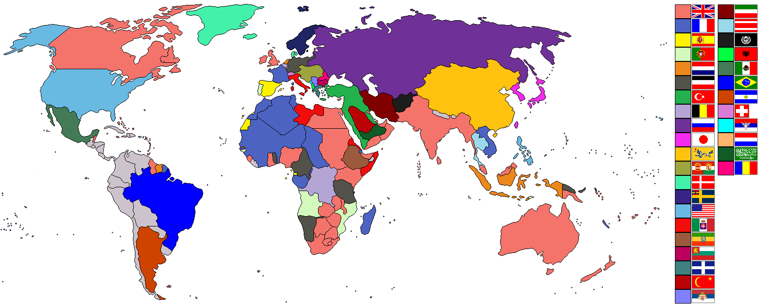
- 2007-08-02 22:04 Ishvara7 1554×627× (73211 bytes) *Ishvara7 *Taken from wikipedia map *Dated around 1900 *Nations involved with imperialism, directly or indirectly, are colored. Meant to potray the world around the time of WWI. *In case anyone wonders, the red flag with the yellow crescent and star is th
The original description page was here. All following user names refer to en.wikipedia.
- 2007-08-02 21:15 Ishvara7 1554×627× (72719 bytes) *Ishvara7 *Taken from wikipedia map *Not all nations are colored. Only ones with the most importance related to colonialism, interaction with colonial powers, and WWI. *Map dates to the year 1900.
The original description page was here. All following user names refer to en.wikipedia.
- 2007-08-02 19:27 Ishvara7 1554×627× (72762 bytes) *Ishvara7 *New nations labled according to importance within world politics and WWI. *Taken from old colonialism wikipedia map
The original description page was here. All following user names refer to en.wikipedia.
- 2007-08-01 01:36 Ishvara7 1458×627× (63275 bytes) *Ishvara7 *Taken from old colonial map on wikipeia and outlined *Better images of flags and includes Ethiopian Empire *yes, it did take forever
فائل دی تریخ
فائل نو اس ویلے دی حالت وچ ویکھن واسطے تاریخ/ویلے تے کلک کرو۔
| تریخ تے ویلہ | نکی مورت | پاسے | ورتن والا | تیپّݨی کرو | |
|---|---|---|---|---|---|
| موجودہ | ۱۴:۰۹, ۸ نومبر ۲۰۲۱ | ۱,۵۵۴ × ۶۲۷ (۶۳ کلوبائٹ) | Randomastwritter | ogaden | |
| ۰۷:۴۸, ۵ دسمبر ۲۰۱۲ | ۱,۵۵۴ × ۶۲۷ (۳۷ کلوبائٹ) | OjdvQ9fNJWl | Uploaded optimized image of first version here at Commons (latest on Wikipedia). File desc for prev version: *Ishvara7 *Taken from wikipedia map *Not all nations are colored. Only ones with the most importance related to colonialism, interaction with c... | ||
| ۰۷:۴۲, ۵ دسمبر ۲۰۱۲ | ۱,۵۵۴ × ۶۲۷ (۷۱ کلوبائٹ) | OjdvQ9fNJWl | Old version from Wikipedia (File:Imperialism.png) dated 21:15, 2 August 2007 by Ishvara7. File desc for prev: *New nations labled according to importance within world politics and WWI. *Taken from old colonialism wikipedia map. | ||
| ۰۷:۲۹, ۵ دسمبر ۲۰۱۲ | ۱,۵۵۴ × ۶۲۷ (۷۱ کلوبائٹ) | OjdvQ9fNJWl | Old version (File:Imperialism6.png) from Wikipedia by Ishvara7 at 19:27, 2 August 2007. File desc for prev upload: *Taken from old colonial map on wikipeia and outlined *Better images of flags and includes Ethiopian Empire *yes, it did take forever. Fi... | ||
| ۰۷:۲۵, ۵ دسمبر ۲۰۱۲ |  | ۱,۴۵۸ × ۶۲۷ (۶۲ کلوبائٹ) | OjdvQ9fNJWl | Uploaded old image version from http://en.wikipedia.org/wiki/File:Imperialism_5.png uploaded by Ishvara7 at 01:36, 1 August 2007 (UTC) | |
| ۰۷:۰۳, ۵ دسمبر ۲۰۱۲ | ۱,۵۵۴ × ۶۲۷ (۷۱ کلوبائٹ) | OjdvQ9fNJWl | {{Information |Description={{en|*Taken from wikipedia map. *Dated around 1900 (shows Italian - although the flag is not correct - North Africa post 1910 and Austro-Hungarian Empire circa WW1). British territories o... |
فائل دی ورتوں
تھلے دتے گئے 1 صفحے اس فائل نال جُڑدے نیں
فائل ویاپک ورتوں
ایہہ دوجے وکیاں ایس فائل نوں ورتدے نیں –
- ar.wikipedia.org تے ورتوں
- bs.wikipedia.org تے ورتوں
- ckb.wikipedia.org تے ورتوں
- en.wikipedia.org تے ورتوں
- fr.wikipedia.org تے ورتوں
- km.wikipedia.org تے ورتوں
- ur.wikipedia.org تے ورتوں