فائل:United Kingdom (overseas+crown dependencies), administrative divisions - Nmbrs (multiple zoom).svg

Size of this PNG preview of this SVG file: ۸۰۰ × ۴۹۳ پکسلز. دوجے ریزولوشنز: ۳۲۰ × ۱۹۷ پکسلز | ۶۴۰ × ۳۹۴ پکسلز | ۱,۰۲۴ × ۶۳۱ پکسلز | ۱,۲۸۰ × ۷۸۹ پکسلز | ۲,۵۶۰ × ۱,۵۷۷ پکسلز | ۳,۱۸۸ × ۱,۹۶۴ پکسلز ۔
اصل فائل (ایس وی جی فائل، پکسل:۳,۱۸۸ × ۱,۹۶۴، فائل سائز: ۶.۰۴ میگابائٹ)
خلاصہ


.svg)


_(Paris_zoom).svg)
.svg)
,_administrative_divisions_-_de_-_colored_(multizoom).svg)
_-_colored.svg)
.svg)
,_administrative_divisions_-_Nmbrs_(multizoom).svg)
,_administrative_divisions_-_de_-_colored.svg)
_-_de_-_colored.svg)

.svg)

.svg)
,_administrative_divisions_-_Nmbrs_(multiple_zoom).svg)
_(W3).svg)
لائسنس –
میں، اس کم دے کاپیرائٹ دا مالک، اس کم نوں اس لائسنس دے مطابق چھاپدا واں:
ایس فائل نوں کریٹو کامنز Attribution 2.0 جنرک لائسنس دتا گیا.
- تہانوں کھلھ اے:
- حصہ کرنا – کاپی، ونڈنا تے کم بھیجنا
- فیر رلانا – کم نوں فٹ کرنا
- تھلے دتیاں شرطاں نال:
- کس دے ناں – تسیں لازمی ایس کم دے بناں والے بارے دسو جنج اونے آکھیا اے یا جنج لسنس چ آکھیا گیا ہے۔
- اکو جہا شئیر کرو۔ – اگر تسیں بدلدے یا ایس کم تے بناندے تے بنن والے کم نوں اینج دے لسنس نال ای ونڈو گے۔

|
I'd greatly appreciate, that you attribute this media file to Wikimedia Commons, if used outside Wikipedia or Commons. For use in publications such as books, newspapers, blogs, websites, please insert here the following line:
|
,_administrative_divisions_-_Nmbrs_(multiple_zoom).svg)
فائل دی تریخ
فائل نو اس ویلے دی حالت وچ ویکھن واسطے تاریخ/ویلے تے کلک کرو۔
| تریخ تے ویلہ | نکی مورت | پاسے | ورتن والا | تیپّݨی کرو | |
|---|---|---|---|---|---|
| موجودہ | ۰۲:۳۰, ۳ ستمبر ۲۰۱۳ | | ۳,۱۸۸ × ۱,۹۶۴ (۶.۰۴ میگابائٹ) | TUBS | |
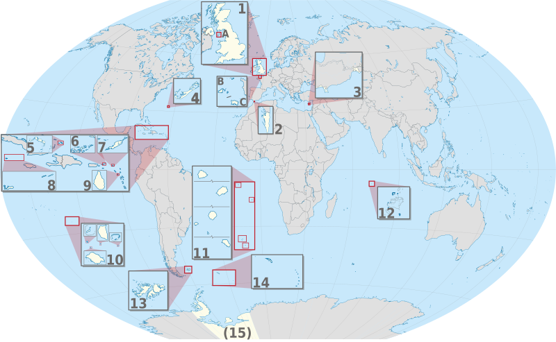
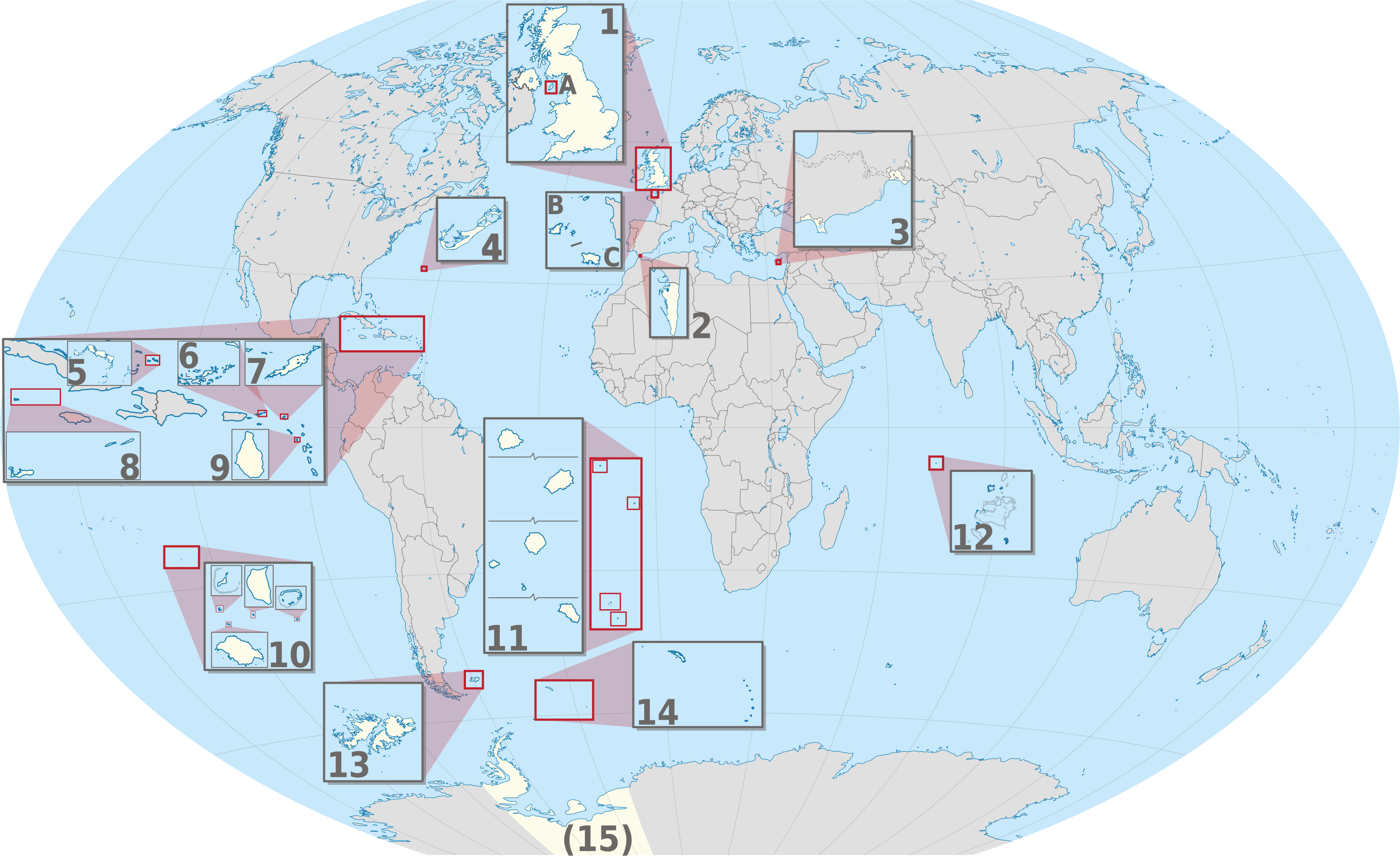
| ۱۶:۰۴, ۲۰ جون ۲۰۱۲ |  | ۳,۱۸۸ × ۱,۹۶۴ (۶.۰۲ میگابائٹ) | TUBS | == {{int:filedesc}} == {{Information |Description={{de|Karte der politischen Gliederung von XY (siehe Dateiname)}} {{en|Map of administrative divisions of XY (see filename)}} |Source={{own}}{{Adobe Illustrator}}{{Commonist}}{{AttribSVG|United Kingdom ... |
فائل دی ورتوں
تھلے دتے گئے 1 صفحے اس فائل نال جُڑدے نیں
فائل ویاپک ورتوں
ایہہ دوجے وکیاں ایس فائل نوں ورتدے نیں –
- am.wikipedia.org تے ورتوں
- bn.wikipedia.org تے ورتوں
- ca.wikipedia.org تے ورتوں
- en.wikivoyage.org تے ورتوں
- ja.wikipedia.org تے ورتوں
- or.wikipedia.org تے ورتوں
- pt.wikipedia.org تے ورتوں
- ro.wikipedia.org تے ورتوں
- tr.wikipedia.org تے ورتوں
- uk.wikipedia.org تے ورتوں
- ur.wikipedia.org تے ورتوں
- vi.wikipedia.org تے ورتوں
- zh.wikipedia.org تے ورتوں
,_administrative_divisions_-_Nmbrs_(multiple_zoom).svg)