برطانوی سمندر پار علاقے
برطانوی سمندر پار علاقے British Overseas Territories | |
|---|---|
 Flag | |
 | |
 | |
| رقبہ | |
• کل | ۱٬۷۲۷٬۵۷۰ کلومیٹر2 (۶۶۷٬۰۲۰ مربع میل) |
| آبادی | |
• تخمینہ | 260,000 |
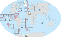
برطانوی سمندر پار علاقے (British Overseas Territories) توں مراد اوہ خطے یا علاقے نيں جو برطانیہ دے تابع یا دائرہ کار دے تحت نيں۔
برطانوی سمندر پار علاقے
سودھوچودہ برطانوی سمندر پار علاقے ایہ نيں۔[۱]
| پرچم | نشان | ناں | مقام | شعار | رقبہ | آبادی | دار الحکومت |
|---|---|---|---|---|---|---|---|
| ایکروتیری و دیکیلیا | بحیرہ روم (قبرص) | ۲۵۵ کلومیٹر2 (۹۸ مربع میل)[۲] | 14,000 (نصف برطانوی فوجی تے عملہ); | ایپسکوپی | |||
| اینگویلا | کیریبین تے شمالی اوقیانوسی علاقے | طاقت تے برداشت | ۱۴۶ کلومیٹر2 (۵۶٫۴ مربع میل)[۳] | 13,500[۴] | دی ویلی | ||
| برمودا | کیریبین تے شمالی اوقیانوسی علاقے | Quo fata ferunt (لاطینی) | ۵۴ کلومیٹر2 (۲۰٫۸ مربع میل)[۵] | 64,000 (2007 تخمینہ)[۶] | ہیملٹن | ||
| برطانوی انٹارکٹک علاقہ | انٹارکٹکا | تحقیق تے دریافت | ۱٬۷۰۹٬۴۰۰ کلومیٹر2 (۶۶۰٬۰۰۰ مربع میل)[۳] | 50 سرما وچ ; 400 گرما وچ [۷] | روتھیرا (مرکزی اڈا) | ||
| برطانوی بحرہند دا خطہ | بحر ہند | In tutela nostra Limuria (لاطینی) | ۴۶ کلومیٹر2 (۱۸ مربع میل)[۸] | تقریبا 3,000 برطانوی تے امریکی فوجی تے عملہ[۹] | ڈیاگو گارسیا (اڈا) | ||
| برطانوی جزیرے ورجن | کیریبین تے شمالی اوقیانوسی علاقے | Vigilate (لاطینی) | ۱۵۳ کلومیٹر2 (۵۹ مربع میل)[۱۰] | 27,000 (2005 تخمینہ)[۱۰] | روڈ ٹاون | ||
| جزیرے کیمین | کیریبین تے شمالی اوقیانوسی علاقے | ۲۶۴ کلومیٹر2 (۱۰۱٫۹ مربع میل)[۱۱] | 54,878[۱۱] | جارج ٹاؤن | |||
| جزیرے فاکلینڈ | جنوبی بحر اوقیانوس | حق دی خواہش | ۱۲٬۱۷۳ کلومیٹر2 (۴٬۷۰۰ مربع میل)[۵] | 2,955 (2006 مردم شماری)[۱۲] | اسٹینلے، جزیرے فاکلینڈ | ||
| جبل الطارق | جزیرہ نما آئبیریا | Nulli expugnabilis hosti (انگریزی: "کوئی دشمن سانوں نئيں کڈے ") | ۶٫۵ کلومیٹر2 (۲٫۵ مربع میل)[۱۳] | 28,800 (2005)[۱۴] | جبل الطارق | ||
| مانٹسریٹ | کیریبین تے شمالی اوقیانوسی علاقے | ۱۰۱ کلومیٹر2 (۳۹ مربع میل)[۱۵] | 4,655 (2006 تخمینہ)[۱۵] | پلایماؤت (باضابطہ مگر آتش فشانی دی وجہ توں خالی بریڈیس) | |||
| جزیرے پٹکیرن | بحر الکاہل | ۴۵ کلومیٹر2 (۱۷ مربع میل) (تمام جزیرے)[۱۶] |
67 (2011) | ایڈمز ٹاؤن | |||
| سینٹ ہلینا، اسینشن و ترسٹان دا کونیا | جنوبی بحر اوقیانوس | وفادار تے غیر متزلزل (سینٹ ہلینا) ساڈے عقیدہ ساڈی طاقت اے (ترسٹان دا کونیا) |
۴۲۰ کلومیٹر2 (۱۶۲ مربع میل) | 5530 کل 4,255 (صرف سینٹ ہلینا; 2008 مردم شماری)[۱۷] 1,275 (اسینشن و ترسٹان دا کونی; تخمینہ)[۱۸] |
جیمز ٹاؤن | ||
| جنوبی جارجیا و جزیرے جنوبی سینڈوچ | جنوبی بحر اوقیانوس | Leo terram propriam protegat (انگریزی: "شیر نوں اپنی زمین دی حفاظت کرنے دو") | ۴٬۰۶۶ کلومیٹر2 (۱٬۵۷۰ مربع میل)[۱۹] | 99[۲۰] | کنگ ایڈورڈ پوائنٹ | ||
| جزیرے کیکس و ترکیہ | کیریبین تے شمالی اوقیانوسی علاقے | "فطرتی خوبصورت، انتخابی صاف" | ۴۳۰ کلومیٹر2 (۱۶۶ مربع میل)[۲۱] | 32,000 (2006 مردم شماری تخمینہ)[۲۱] | کاک برن ٹاؤن |
حوالے
سودھو- ↑ Lua error in ماڈیول:Citation/CS1/Date_validation/ar at line 45: attempt to compare number with nil.
- ↑ Lua error in ماڈیول:Citation/CS1/Date_validation/ar at line 45: attempt to compare number with nil.
- ↑ ۳.۰ ۳.۱ Lua error in ماڈیول:Citation/CS1/Date_validation/ar at line 45: attempt to compare number with nil.
- ↑ Lua error in ماڈیول:Citation/CS1/Date_validation/ar at line 45: attempt to compare number with nil.
- ↑ ۵.۰ ۵.۱ Lua error in ماڈیول:Citation/CS1/Date_validation/ar at line 45: attempt to compare number with nil.
- ↑ Lua error in ماڈیول:Citation/CS1/Date_validation/ar at line 45: attempt to compare number with nil.
- ↑ Lua error in ماڈیول:Citation/CS1/Date_validation/ar at line 45: attempt to compare number with nil.
- ↑ Lua error in ماڈیول:Citation/CS1/Date_validation/ar at line 45: attempt to compare number with nil.
- ↑ Lua error in ماڈیول:Citation/CS1/Date_validation/ar at line 45: attempt to compare number with nil.
- ↑ ۱۰.۰ ۱۰.۱ %7B%7Bcite web|url=http://www.jncc.gov.uk/page-4395 Archived 2010-10-13 at the وے بیک مشین |title=British Virgin Islands (BVI) |publisher=Jncc.gov.uk |accessdate=8 December 2010}}
- ↑ ۱۱.۰ ۱۱.۱ Lua error in ماڈیول:Citation/CS1/Date_validation/ar at line 45: attempt to compare number with nil.
- ↑ Lua error in ماڈیول:Citation/CS1/Date_validation/ar at line 45: attempt to compare number with nil.
- ↑ Lua error in ماڈیول:Citation/CS1/Date_validation/ar at line 45: attempt to compare number with nil.
- ↑ Lua error in ماڈیول:Citation/CS1/Date_validation/ar at line 45: attempt to compare number with nil.
- ↑ ۱۵.۰ ۱۵.۱ %7B%7Bcite web|url=http://www.jncc.gov.uk/page-4397 Archived 2010-10-13 at the وے بیک مشین |title=Montserrat |publisher=Jncc.gov.uk |accessdate=8 December 2010}}
- ↑ Lua error in ماڈیول:Citation/CS1/Date_validation/ar at line 45: attempt to compare number with nil.
- ↑ Lua error in ماڈیول:Citation/CS1/Date_validation/ar at line 45: attempt to compare number with nil.
- ↑ Lua error in ماڈیول:Citation/CS1/Date_validation/ar at line 45: attempt to compare number with nil.
- ↑ Lua error in ماڈیول:Citation/CS1/Date_validation/ar at line 45: attempt to compare number with nil.
- ↑ Lua error in ماڈیول:Citation/CS1/Date_validation/ar at line 45: attempt to compare number with nil.
- ↑ ۲۱.۰ ۲۱.۱ %7B%7Bcite web|url=http://www.jncc.gov.uk/page-4398 Archived 2012-09-12 at the وے بیک مشین |title=Turks and Caicos Islands |publisher=Jncc.gov.uk |date=1 November 2009 |accessdate=8 December 2010}}