فائل:Spread of Christianity to AD 600 - Atlas of World History.png

ایس وکھالے دا ناپ: ۸۰۰ × ۵۹۲ پکسلز۔ دوجے ریزولوشنز: ۳۲۰ × ۲۳۷ پکسلز | ۶۴۰ × ۴۷۴ پکسلز | ۱,۰۲۴ × ۷۵۸ پکسلز | ۱,۲۸۰ × ۹۴۸ پکسلز | ۲,۱۸۷ × ۱,۶۱۹ پکسلز ۔
اصل فائل (۲,۱۸۷ × ۱,۶۱۹ پکسلز, فائل حجم: ۲۲۷ کلوبائٹ, MIME type: image/png)
خلاصہ
| تفصیل |
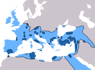
English: Map of the spread of Christianity in Europe, Southwest Asia and North Africa to the year AD 600.
"redominantly Christian by AD 325" zone coloured in dark blue, "Predominantly Christian by AD 600" coloured in light blue.
Predominantly Christian by AD 325
Predominantly Christian by AD 600
Magyar: A kereszténység elterjedése:
Kr. u. 325-ig
325 és 600 között
Information obtained from Patrick O'Brien , ed. (۲۰۰۳) Atlas of World History، Category:New York: Oxford University Press، pp. 44−5 0-19-521921-X Map created and uploaded in the English Wikipedia by Geuiwogbil. Base map: "File:BlankMap-Europe-v3.png" |
| تریخ | ۲۷ مئی ۲۰۰۹ (original upload date) |
| سروت | Transferred from en.wikipedia to Commons by QuartierLatin1968 using CommonsHelper. |
| لکھاری | Geuiwogbil at English وکیپیڈیا |

|
This religion map image could be re-created using vector graphics as an SVG file. This has several advantages; see Commons:Media for cleanup for more information. If an SVG form of this image is available, please upload it and afterwards replace this template with
{{vector version available|new image name}}.
It is recommended to name the SVG file “Spread of Christianity to AD 600 - Atlas of World History.svg”—then the template Vector version available (or Vva) does not need the new image name parameter. |
لائسنس –
Geuiwogbil from en.wikipedia.org، اس کم دے کاپیرائٹ دا مالک، اس کم نوں اس لائسنس دے مطابق چھاپدا واں:
| ایس فائل نوں کریٹو کامنز Attribution 2.5 پولینڈ لائسنس دتا گیا. Subject to disclaimers. | ||
| کس دے ناں: Geuiwogbil from en.wikipedia.org | ||
| ||
| اس لائسنس دا ٹیگ GFDL دے مطابق اس فائل چ پایا گیا اے licensing update۔ |

|
کاپی کرن، ونڈن تے بدلن دی ایس ڈوکومنٹ لئی اجازت دتی جاندی اے ایہناں GNU Free Documentation License, Version 1.2 شرطاں نال یا مگروں کسے وی چھپے ورین Free Software Foundation توں بنا کسے انویرینٹ سیکشن دے، ناں فرنٹ کور لکھت تے ناں بیک کور لکھت دے۔ لسنس دی اک کاپی سیکشن وچ ہیگی اے جہدا ناں اے GNU Free Documentation License۔ Subject to disclaimers. |
پہلا اپلوڈ دا ریکارڈ
The original description page was here. All following user names refer to en.wikipedia.
- 2009-05-27 19:20 Carlaude 2187×1619× (232587 bytes) Cutting out unused areas of the map
- 2006-09-09 02:34 Geuiwogbil 2285×2181× (248280 bytes) Blue provides us with a better constrast.
- 2006-09-04 05:10 Geuiwogbil 2285×2181× (254524 bytes)
- 2006-09-04 05:08 Geuiwogbil 2285×2181× (116034 bytes) Map of the spread of Christianity in Europe, Southwest Asia and North Africa to the year 600 AD. Base map "BlankMap-Europe-v.3." Spread of Christianity to AD 325 coloured in orange, to 600 coloured in yellow. Information obtained from {{cite book |editor=
فائل دی تریخ
فائل نو اس ویلے دی حالت وچ ویکھن واسطے تاریخ/ویلے تے کلک کرو۔
| تریخ تے ویلہ | نکی مورت | پاسے | ورتن والا | تیپّݨی کرو | |
|---|---|---|---|---|---|
| موجودہ | ۲۲:۳۱, ۳ جون ۲۰۲۲ | | ۲,۱۸۷ × ۱,۶۱۹ (۲۲۷ کلوبائٹ) | Veverve | Reverted to version as of 10:19, 4 July 2021 (UTC) please bring a map source to counter this claim that only part of Armenia etc. were partially christianised |
| ۲۲:۰۸, ۳ جون ۲۰۲۲ |  | ۲,۱۸۷ × ۱,۶۱۹ (۲۴۵ کلوبائٹ) | Rs4815 | Reverted to version as of 09:58, 24 February 2013 (UTC) You can't just ignore the fact that the "sourced version of the map" has a blunder. By the year 325, the Armenian kingdom had already been converted to Christianity | |
| ۱۵:۱۹, ۴ جولائی ۲۰۲۱ |  | ۲,۱۸۷ × ۱,۶۱۹ (۲۲۷ کلوبائٹ) | Veverve | Reverted to version as of 12:31, 9 November 2009 (UTC) revert to what is an actually sourced version of the map | |
| ۱۱:۳۴, ۲۳ مئی ۲۰۱۸ |  | ۲,۱۸۷ × ۱,۶۱۹ (۲۱۳ کلوبائٹ) | Inowen | Add labels for Europe, Africa, and Middle East using Inkscape to import previous and overlay text in svg. | |
| ۱۴:۵۸, ۲۴ فروری ۲۰۱۳ |  | ۲,۱۸۷ × ۱,۶۱۹ (۲۴۵ کلوبائٹ) | Prince of Nothing05 | Kingdom of Armenia, Iberia and Caucasian Albania had already made Christianity official religion. | |
| ۱۷:۳۱, ۹ نومبر ۲۰۰۹ |  | ۲,۱۸۷ × ۱,۶۱۹ (۲۲۷ کلوبائٹ) | QuartierLatin1968 | {{Information |Description={{en|Map of the spread of Christianity in Europe, Southwest Asia and North Africa to the year 600 AD. Base map "BlankMap-Europe-v.3." Spread of Christianity to AD 325 coloured in light blue, to 600 coloured in dark blue. Informa |
فائل دی ورتوں
تھلے دتے گئے 1 صفحے اس فائل نال جُڑدے نیں
فائل ویاپک ورتوں
ایہہ دوجے وکیاں ایس فائل نوں ورتدے نیں –
- ar.wikipedia.org تے ورتوں
- arz.wikipedia.org تے ورتوں
- be.wikipedia.org تے ورتوں
- bg.wikipedia.org تے ورتوں
- ca.wikipedia.org تے ورتوں
- cs.wikipedia.org تے ورتوں
- de.wikipedia.org تے ورتوں
- el.wikipedia.org تے ورتوں
- en.wikipedia.org تے ورتوں
- Christendom
- Christian Church
- Christianity in Africa
- Talk:Christian Church/Archive 1
- Christianity in the Middle East
- Spread of Christianity
- Multiculturalism and Christianity
- Western world
- Christianity in the ante-Nicene period
- Christianity in the 4th century
- Christianity in the 5th century
- Christianity in the 6th century
- Christianity in the 7th century
- Christianity in late antiquity
- Christianity as the Roman state religion
- Roman people
- User:Falcaorib
- en.wikibooks.org تے ورتوں
- en.wikiquote.org تے ورتوں
- eo.wikipedia.org تے ورتوں
- es.wikipedia.org تے ورتوں
ایس فائل دا ویکھو ہور جگت ورتن .