فائل:PeelMap.png
ایس وکھالے دا ناپ: ۲۵۰ × ۵۹۹ پکسلز۔ دوجے ریزولوشنز: ۱۰۰ × ۲۴۰ پکسلز | ۲۰۰ × ۴۸۰ پکسلز ۔
اصل فائل (۸۰۰ × ۱,۹۱۸ پکسلز, فائل حجم: ۱۲۳ کلوبائٹ, MIME type: image/png)
خلاصہ
| تفصیل |
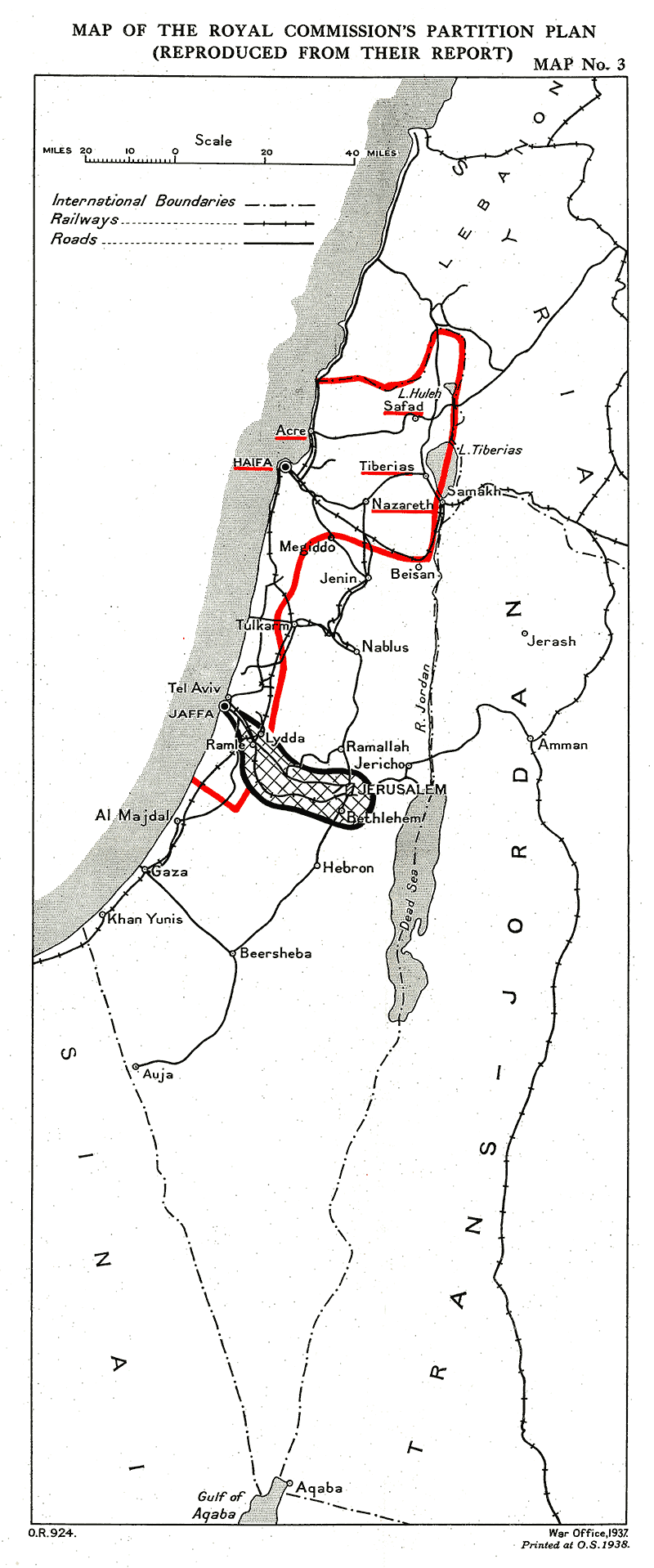
English: Provisional frontiers of the Palestine partition according to the Palestine Royal Commission (Peel report)
العربية: الحدود المؤقتة لتقسيم فلسطين حسب الهيئة الملكية الفلسطينية (تقرير بيل) |
| تریخ | |
| سروت |
 |
| لکھاری | UK Government |
لائسنس –
This work created by the United Kingdom Government is in the public domain.
This is because it is one of the following:
HMSO has declared that the expiry of Crown Copyrights applies worldwide (ref: HMSO Email Reply)
|
 |
فائل دی تریخ
فائل نو اس ویلے دی حالت وچ ویکھن واسطے تاریخ/ویلے تے کلک کرو۔
| تریخ تے ویلہ | نکی مورت | پاسے | ورتن والا | تیپّݨی کرو | |
|---|---|---|---|---|---|
| موجودہ | ۱۹:۴۰, ۲۶ ستمبر ۲۰۱۱ | | ۸۰۰ × ۱,۹۱۸ (۱۲۳ کلوبائٹ) | Zero0000 |
فائل دی ورتوں
تھلے دتے گئے 1 صفحے اس فائل نال جُڑدے نیں
فائل ویاپک ورتوں
ایہہ دوجے وکیاں ایس فائل نوں ورتدے نیں –
- ar.wikipedia.org تے ورتوں
- en.wikipedia.org تے ورتوں
- eo.wikipedia.org تے ورتوں
- es.wikipedia.org تے ورتوں
- he.wikipedia.org تے ورتوں
- id.wikipedia.org تے ورتوں
- ml.wikipedia.org تے ورتوں
- nl.wikipedia.org تے ورتوں
- pt.wikipedia.org تے ورتوں
- ur.wikipedia.org تے ورتوں
- www.wikidata.org تے ورتوں
- zh.wikipedia.org تے ورتوں