فائل:Palestine election map.PNG

ایس وکھالے دا ناپ: ۴۳۷ × ۶۰۰ پکسلز۔ دوجے ریزولوشنز: ۱۷۵ × ۲۴۰ پکسلز | ۳۵۰ × ۴۸۰ پکسلز | ۵۶۰ × ۷۶۸ پکسلز | ۱,۱۱۵ × ۱,۵۳۰ پکسلز ۔
اصل فائل (۱,۱۱۵ × ۱,۵۳۰ پکسلز, فائل حجم: ۱۰۶ کلوبائٹ, MIME type: image/png)

|
This election map image could be re-created using vector graphics as an SVG file. This has several advantages; see Commons:Media for cleanup for more information. If an SVG form of this image is available, please upload it and afterwards replace this template with
{{vector version available|new image name}}.
It is recommended to name the SVG file “Palestine election map.svg”—then the template Vector version available (or Vva) does not need the new image name parameter. |
خلاصہ
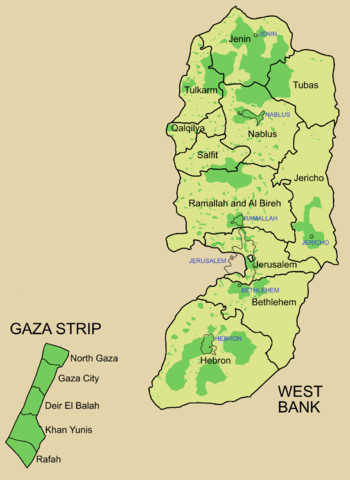
Palestine divided into electoral districts (as of 2006), marked with thick black borders. (thinner borders show boundaries of cities, with city names marked in blue). Green shows areas of formal Palestinian authority. Map made using information from other maps such as this. There is a map of the West Bank and Gaza governates from 1995 here
لائسنس –

|
کاپی کرن، ونڈن تے بدلن دی ایس ڈوکومنٹ لئی اجازت دتی جاندی اے ایہناں GNU Free Documentation License, Version 1.2 شرطاں نال یا مگروں کسے وی چھپے ورین Free Software Foundation توں بنا کسے انویرینٹ سیکشن دے، ناں فرنٹ کور لکھت تے ناں بیک کور لکھت دے۔ لسنس دی اک کاپی سیکشن وچ ہیگی اے جہدا ناں اے GNU Free Documentation License۔ |
| ایس فائل نوں کریٹو کامنز Attribution 2.5 پولینڈ لائسنس دتا گیا. | ||
| ||
| اس لائسنس دا ٹیگ GFDL دے مطابق اس فائل چ پایا گیا اے licensing update۔ |
فائل دی تریخ
فائل نو اس ویلے دی حالت وچ ویکھن واسطے تاریخ/ویلے تے کلک کرو۔
| تریخ تے ویلہ | نکی مورت | پاسے | ورتن والا | تیپّݨی کرو | |
|---|---|---|---|---|---|
| موجودہ | ۱۴:۵۷, ۵ جولائی ۲۰۰۶ | | ۱,۱۱۵ × ۱,۵۳۰ (۱۰۶ کلوبائٹ) | Roke~commonswiki | request to make all of gaza strip dark green |
| ۱۰:۳۸, ۲۸ جنوری ۲۰۰۶ |  | ۱,۱۱۵ × ۱,۵۳۰ (۱۰۴ کلوبائٹ) | Roke~commonswiki | Palestine divided into electoral districts, marked with black borders. Green shows areas of formal Palestinian authority. I made the map, using information from other maps such as [http://www.nytimes.com/imagepages/2006/01/25/international/20060125_palest |
فائل دی ورتوں
تھلے دتے گئے 1 صفحے اس فائل نال جُڑدے نیں
فائل ویاپک ورتوں
ایہہ دوجے وکیاں ایس فائل نوں ورتدے نیں –
- arz.wikipedia.org تے ورتوں
- bcl.wikipedia.org تے ورتوں
- be.wikipedia.org تے ورتوں
- bn.wikipedia.org تے ورتوں
- br.wikipedia.org تے ورتوں
- ca.wikipedia.org تے ورتوں
- cs.wikipedia.org تے ورتوں
- en.wikipedia.org تے ورتوں
- Palestinian territories
- State of Palestine
- List of cities administered by the Palestinian Authority
- Governorates of Palestine
- Template talk:Governorates of the State of Palestine
- Next Palestinian legislative election
- Condoleezza Rice's tenure as Secretary of State
- Talk:Next Palestinian legislative election
- 2006 Palestinian legislative election
- User:Falcaorib
- en.wikinews.org تے ورتوں
- eo.wikipedia.org تے ورتوں
- es.wikipedia.org تے ورتوں
- es.wikinews.org تے ورتوں
- fa.wikipedia.org تے ورتوں
- fr.wikipedia.org تے ورتوں
- gv.wikipedia.org تے ورتوں
- he.wikipedia.org تے ورتوں
- hy.wikipedia.org تے ورتوں
- id.wikipedia.org تے ورتوں
- it.wikipedia.org تے ورتوں
- ja.wikipedia.org تے ورتوں
- ja.wikinews.org تے ورتوں
- ko.wikipedia.org تے ورتوں
- ms.wikipedia.org تے ورتوں
ایس فائل دا ویکھو ہور جگت ورتن .