فائل:Map of Israel, neighbours and occupied territories.svg

اصل فائل (ایس وی جی فائل، پکسل:۵۵۹ × ۷۲۱، فائل سائز: ۶۵۰ کلوبائٹ)
خلاصہ
| تفصیل |
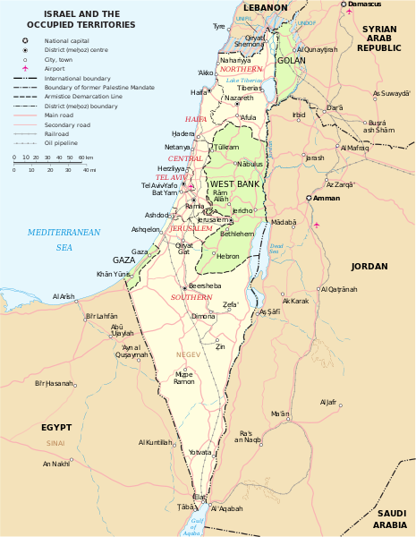
English: Map of the Middle East showing Israel, Egypt, Saudi Arabia, Jordan, Syria and Lebanon including Gaza, Golan Heights and West Bank.
العربية: خريطة دولة إسرائيل والأراضي الفلسطينية التي تشمل الضفة الغربية وقطاع غزة والجولان السوري المحتل. |
| تریخ | |
| سروت | SVG extracted and edited from PDF |
| لکھاری | un.org |
| دوجے ورژن | македонски |
| SVG genesis |
لائسنس –
| This image is a map derived from a United Nations map.
Unless stated otherwise, UN maps are to be considered in the public domain. This applies worldwide. UN maps are, in principle, open source material and you can use them in your work or for making your own map. UN requests however that you delete the UN name, logo and reference number upon any modification to the map. Content of your map will be your responsibility. You can state in your publication, if you wish, something like: based on UN map … (map name, map number, revision number and date). See: Geospatial Information Section. And: Geospatial, location data for a better world. |
 |
| میں، اس کم دے کاپیرائٹ دا مالک، اس کم نوں لوکاں واسطے دیندا واں۔ اے سارے جگ واسطے لاگو اے۔ کج ملکاں چ قانونی طور تے اے ممکن نئیں اے؛ اگر انج ای اے ے: میں ہر کسے نوں اس کم نوں کسے وی مقصد واسطے ورتن دا بغیر کسے شرط دے حق دیندا واں، اگر اوہ قانون دے خلاف نا ہوۓ۔ |
فائل دی تریخ
فائل نو اس ویلے دی حالت وچ ویکھن واسطے تاریخ/ویلے تے کلک کرو۔
| تریخ تے ویلہ | نکی مورت | پاسے | ورتن والا | تیپّݨی کرو | |
|---|---|---|---|---|---|
| موجودہ | ۲۱:۰۷, ۷ اکتوبر ۲۰۲۳ | | ۵۵۹ × ۷۲۱ (۶۵۰ کلوبائٹ) | LametinoWiki | File uploaded using svgtranslate tool (https://svgtranslate.toolforge.org/). Added translation for it. |
| ۲۱:۰۷, ۷ اکتوبر ۲۰۲۳ |  | ۵۵۹ × ۷۲۱ (۶۵۰ کلوبائٹ) | LametinoWiki | File uploaded using svgtranslate tool (https://svgtranslate.toolforge.org/). Added translation for it. | |
| ۰۶:۴۹, ۲۷ دسمبر ۲۰۲۲ |  | ۵۵۹ × ۷۲۱ (۵۹۶ کلوبائٹ) | Wikijahnn | File uploaded using svgtranslate tool (https://svgtranslate.toolforge.org/). Added translation for ca. | |
| ۰۶:۴۶, ۲۷ دسمبر ۲۰۲۲ |  | ۵۵۹ × ۷۲۱ (۵۹۶ کلوبائٹ) | Wikijahnn | File uploaded using svgtranslate tool (https://svgtranslate.toolforge.org/). Added translation for ca. | |
| ۲۲:۰۹, ۵ مئی ۲۰۱۸ |  | ۵۵۹ × ۷۲۱ (۵۴۰ کلوبائٹ) | FrankieF | Reverted to version as of 23:22, 5 March 2018 (UTC). Replaces a bad and blurred map without distance meter to a crisp and clear map. | |
| ۲۳:۴۷, ۱۰ مارچ ۲۰۱۸ |  | ۵۵۹ × ۷۲۱ (۲۸۵ کلوبائٹ) | Eric's son | The last version is outdated and factually incorrect. Reverted to version as of 21:50, 26 February 2018 (UTC) | |
| ۰۴:۲۲, ۶ مارچ ۲۰۱۸ |  | ۵۵۹ × ۷۲۱ (۵۴۰ کلوبائٹ) | Nableezy | Reverted to version as of 16:20, 12 December 2011 (UTC) make a different map, dont replace every other with this one | |
| ۰۲:۵۰, ۲۷ فروری ۲۰۱۸ |  | ۵۵۹ × ۷۲۱ (۲۸۵ کلوبائٹ) | Eric's son | small graphic fixes | |
| ۰۳:۲۴, ۲۰ فروری ۲۰۱۸ |  | ۵۵۹ × ۷۲۱ (۲۵۹ کلوبائٹ) | Eric's son | Adding relevant updates (evacuated UN zones), clear colored borders explained in legend. | |
| ۲۱:۲۰, ۱۲ دسمبر ۲۰۱۱ |  | ۵۵۹ × ۷۲۱ (۵۴۰ کلوبائٹ) | Ch1902 | =={{int:filedesc}}== {{Information |Description={{en|1=Map of the Middle East showing Israel, Egypt, Saudi Arabia, Jordan, Syria and Lebanon including Gaza, Golan Heights and West Bank.}} |Source=SVG extracted and edited from [http://www.un.org/Depts/Car |
فائل دی ورتوں
تھلے دتے گئے 1 صفحے اس فائل نال جُڑدے نیں
فائل ویاپک ورتوں
ایہہ دوجے وکیاں ایس فائل نوں ورتدے نیں –
- ary.wikipedia.org تے ورتوں
- azb.wikipedia.org تے ورتوں
- bxr.wikipedia.org تے ورتوں
- ca.wikipedia.org تے ورتوں
- da.wikipedia.org تے ورتوں
- en.wikipedia.org تے ورتوں
- ga.wikipedia.org تے ورتوں
- gl.wikipedia.org تے ورتوں
- hy.wikipedia.org تے ورتوں
- it.wikipedia.org تے ورتوں
- kn.wikipedia.org تے ورتوں
- ko.wikipedia.org تے ورتوں
- nl.wikipedia.org تے ورتوں
- pap.wikipedia.org تے ورتوں
- ru.wikipedia.org تے ورتوں
- sr.wikipedia.org تے ورتوں
- sv.wikipedia.org تے ورتوں
- www.wikidata.org تے ورتوں