فائل:LakeKivu satellite.jpg
اس توں وڈی مورت موجود نہیں۔
LakeKivu_satellite.jpg (۲۹۶ × ۴۶۴ پکسلز, فائل حجم: ۲۱ کلوبائٹ, MIME type: image/jpeg)
خلاصہ
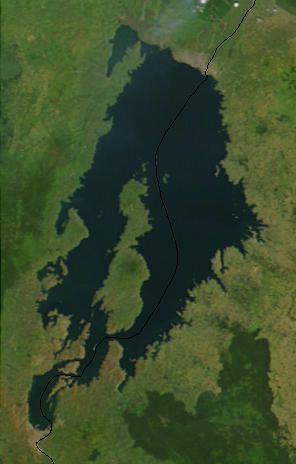
| تفصیل |
English: Lake Kivu, Africa, as seen from space. The black line marks the border between Rwanda and the Democratic Republic of the Congo. Cropped from a larger image (EAfrica.A2003033.0820.250m.jpg). |
| تریخ | |
| سروت | "Fires in East Africa" - Visible Earth Image ID 4957 (details, image at 250m resolution) |
| لکھاری | NASA |
لائسنس –
| This file is in the public domain in the United States because it was solely created by NASA. NASA copyright policy states that "NASA material is not protected by copyright unless noted". (See Template:PD-USGov, NASA copyright policy page or JPL Image Use Policy.) | ||
 |
Warnings:
|
پہلا اپلوڈ دا ریکارڈ
from en.wikipedia.org
- Uploaded on 23 February 2006 by en:User:Paphrag.
فائل دی تریخ
فائل نو اس ویلے دی حالت وچ ویکھن واسطے تاریخ/ویلے تے کلک کرو۔
| تریخ تے ویلہ | نکی مورت | پاسے | ورتن والا | تیپّݨی کرو | |
|---|---|---|---|---|---|
| موجودہ | ۱۹:۱۹, ۱۹ ستمبر ۲۰۱۰ | | ۲۹۶ × ۴۶۴ (۲۱ کلوبائٹ) | LobStoR | lossless crop from source NASA image at 250m resolution |
| ۰۳:۴۳, ۲۵ مئی ۲۰۰۶ |  | ۲۹۵ × ۴۷۶ (۱۰۸ کلوبائٹ) | Dubhe | from en.wiki |
فائل دی ورتوں
تھلے دتے گئے 1 صفحے اس فائل نال جُڑدے نیں
فائل ویاپک ورتوں
ایہہ دوجے وکیاں ایس فائل نوں ورتدے نیں –
- af.wikipedia.org تے ورتوں
- ar.wikipedia.org تے ورتوں
- arz.wikipedia.org تے ورتوں
- ast.wikipedia.org تے ورتوں
- bn.wikipedia.org تے ورتوں
- br.wikipedia.org تے ورتوں
- ca.wikipedia.org تے ورتوں
- ceb.wikipedia.org تے ورتوں
- cs.wikipedia.org تے ورتوں
- da.wikipedia.org تے ورتوں
- de.wikipedia.org تے ورتوں
- de.wikivoyage.org تے ورتوں
- dsb.wikipedia.org تے ورتوں
- el.wikipedia.org تے ورتوں
- en.wikipedia.org تے ورتوں
- eo.wikipedia.org تے ورتوں
- es.wikipedia.org تے ورتوں
- et.wikipedia.org تے ورتوں
- eu.wikipedia.org تے ورتوں
- fa.wikipedia.org تے ورتوں
- fi.wikipedia.org تے ورتوں
- fr.wikipedia.org تے ورتوں
- fr.wikivoyage.org تے ورتوں
- gl.wikipedia.org تے ورتوں
- he.wikipedia.org تے ورتوں
- hsb.wikipedia.org تے ورتوں
- hy.wikipedia.org تے ورتوں
- ig.wikipedia.org تے ورتوں
- it.wikipedia.org تے ورتوں
- ja.wikipedia.org تے ورتوں
- ka.wikipedia.org تے ورتوں
- ko.wikipedia.org تے ورتوں
ایس فائل دا ویکھو ہور جگت ورتن .