فائل:EasternBloc BorderChange38-48.svg

Size of this PNG preview of this SVG file: ۳۵۲ × ۵۹۸ پکسلز. دوجے ریزولوشنز: ۱۴۱ × ۲۴۰ پکسلز | ۲۸۲ × ۴۸۰ پکسلز | ۴۵۲ × ۷۶۸ پکسلز | ۶۰۲ × ۱,۰۲۴ پکسلز | ۱,۲۰۴ × ۲,۰۴۸ پکسلز | ۴۰۰ × ۶۸۰ پکسلز ۔
اصل فائل (ایس وی جی فائل، پکسل:۴۰۰ × ۶۸۰، فائل سائز: ۱.۳۹ میگابائٹ)
| تفصیل |
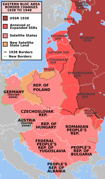
e* Description: Former Eastern Bloc area border changes between 1938 and 1948.
The border and other changes include:
|
||||||||
| سروت | en.wiki | ||||||||
| لکھاری | Mosedschurte | ||||||||
| اجازت (فائل نوں دوبارہ ورتنا) |
|
||||||||
| دوجے ورژن | العربيَّة, Türkçe |

فائل دی تریخ
فائل نو اس ویلے دی حالت وچ ویکھن واسطے تاریخ/ویلے تے کلک کرو۔
| تریخ تے ویلہ | نکی مورت | پاسے | ورتن والا | تیپّݨی کرو | |
|---|---|---|---|---|---|
| موجودہ | ۰۳:۲۲, ۱۸ جولائی ۲۰۲۳ | | ۴۰۰ × ۶۸۰ (۱.۳۹ میگابائٹ) | Spesh531 | Corrected 1948-Moldavian SSR lines (white -> green). Thinned out 1948 Estonia & Latvia green lines to match the SSR-SSR border thickness |
| ۰۵:۴۲, ۴ مارچ ۲۰۲۱ |  | ۴۰۰ × ۶۸۰ (۱.۳۸ میگابائٹ) | Spesh531 | Fixing Czechoslovakia before covered the Austro-Hungarian-Slovak border | |
| ۰۵:۳۹, ۴ مارچ ۲۰۲۱ |  | ۴۰۰ × ۶۸۰ (۱.۳۸ میگابائٹ) | Spesh531 | I missed Odessa! Which should be the neutral red like Moldova | |
| ۱۸:۴۵, ۳ مارچ ۲۰۲۱ |  | ۴۰۰ × ۶۸۰ (۱.۳۷ میگابائٹ) | Spesh531 | Hiding internal borders of Yugoslavia and Czechoslovakia | |
| ۱۸:۴۰, ۳ مارچ ۲۰۲۱ |  | ۴۰۰ × ۶۸۰ (۱.۳۳ میگابائٹ) | Spesh531 | Overhaul of borders. Fixed Julian March. Added Austria occupied zone, Polish-Czech border changes, Austrian/Hungarian/Slovakian tripoint, and better detail in Karelia. | |
| ۰۴:۳۳, ۱۰ مارچ ۲۰۱۹ |  | ۳۹۶ × ۶۴۳ (۵۸۱ کلوبائٹ) | AndreyKva | Optimized. | |
| ۱۸:۰۷, ۹ جنوری ۲۰۱۱ |  | ۳۹۶ × ۶۴۳ (۷۶۵ کلوبائٹ) | Alokasta~commonswiki | Small changes + I changed east border of Poland: On the old version of this map there was the border after Polish-Soviet territorial exchange in 1951. More info: http://en.wikipedia.org/wiki/1951_Polish–Soviet_territorial_exchange | |
| ۱۷:۴۱, ۹ جنوری ۲۰۱۱ |  | ۳۹۶ × ۶۴۳ (۷۶۳ کلوبائٹ) | Alokasta~commonswiki | I corrected the polish-german border - in 1938 the Hel Peninsula was the territory of Poland. I changed also the border between Poalnd and Free City of Danzig. I added a white line along the Polish coast. | |
| ۰۷:۲۱, ۱۶ ستمبر ۲۰۰۹ |  | ۳۹۶ × ۶۴۳ (۷۴۵ کلوبائٹ) | Stiepan Pietrov | {{Information |Description=e* Description: Former Eastern Bloc area border changes between 1938 and 1948. * Source: Map borders primarily based on [http://commons.wikimedia.org/wiki/File:EC12-1986_European_Community_map.svg] and [http://commons.wikime |
فائل دی ورتوں
تھلے دتے گئے 3 صفحے اس فائل نال جُڑدے نیں
فائل ویاپک ورتوں
ایہہ دوجے وکیاں ایس فائل نوں ورتدے نیں –
- af.wikipedia.org تے ورتوں
- ar.wikipedia.org تے ورتوں
- azb.wikipedia.org تے ورتوں
- az.wikipedia.org تے ورتوں
- bg.wikipedia.org تے ورتوں
- bn.wikipedia.org تے ورتوں
- ca.wikipedia.org تے ورتوں
- cs.wikipedia.org تے ورتوں
- da.wikipedia.org تے ورتوں
- de.wikipedia.org تے ورتوں
- el.wikipedia.org تے ورتوں
- el.wiktionary.org تے ورتوں
- en.wikipedia.org تے ورتوں
- Molotov–Ribbentrop Pact
- World War II
- Eastern Bloc
- History of the United States (1945–1964)
- Cold War
- Origins of the Cold War
- History of the Soviet Union (1927–1953)
- Reinhard Gehlen
- List of national border changes (1914–present)
- Aftermath of World War II
- Military occupations by the Soviet Union
- Key events of the 20th century
- Soviet famine of 1946–1947
- Gehlen Organization
- Political warfare
- User:JacksonKo/ideology
- User:Paul Siebert/sandbox
- User:Falcaorib
- User:Shafin10555/sandbox
- User:Hmmmmm maybe/sandbox
- Cold War (1947–1948)
- Draft:World War II (Draft)
- en.wikiquote.org تے ورتوں
- eo.wikiquote.org تے ورتوں
- es.wikipedia.org تے ورتوں
- et.wikipedia.org تے ورتوں
- eu.wikipedia.org تے ورتوں
- fa.wikipedia.org تے ورتوں
- fi.wikipedia.org تے ورتوں
- fr.wikipedia.org تے ورتوں
- gl.wikipedia.org تے ورتوں
- hif.wikipedia.org تے ورتوں
- hy.wikipedia.org تے ورتوں
ایس فائل دا ویکھو ہور جگت ورتن .