فائل:Chernyakhov.PNG
اس توں وڈی مورت موجود نہیں۔
Chernyakhov.PNG (۷۷۷ × ۴۷۱ پکسلز, فائل حجم: ۱۰ کلوبائٹ, MIME type: image/png)
خلاصہ

|
File:Chernyakhov.svg is a vector version of this file. It should be used in place of this PNG file when not inferior.
File:Chernyakhov.PNG → File:Chernyakhov.svg
For more information, see Help:SVG. |
 |
| تفصیل |
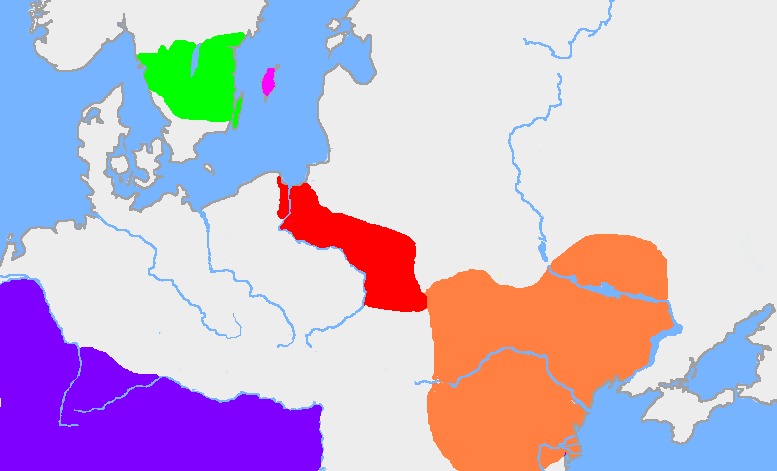
English: The green area is the traditional extent of Götaland and the pink area is the island of Gotland. The red area is the extent of the Wielbark culture in the early 3rd century, and the orange area is the Chernyakhov culture, in the early 4th century. The purple area is the Roman Empire.
The extent of the Wielbark culture is based on Zbigniew Babik: "Najstarsza warstwa nazewnicza na ziemiach polskich" Cracow 2001. The extent of the Chernyakhov culture is based on R. Wołągiewicz (1993), a map drawn by Lars Östlin, in Kaliff's Gothic Connections. Contacts between eastern Scandinavia and the southern Baltic coast 1000 BC – 500 AD (2001:29)Deutsch: Ungefähre Ausbildung der Chernjachov-Kultur im 3. Jahrhundert (orange) und der Wielbark-Kultur (rot). |
| سروت | Wiglaf's map, based on Dbachmann's blank map. |
| لکھاری | en:User:Wiglaf, en:User:Dbachmann |
لائسنس –

|
کاپی کرن، ونڈن تے بدلن دی ایس ڈوکومنٹ لئی اجازت دتی جاندی اے ایہناں GNU Free Documentation License, Version 1.2 شرطاں نال یا مگروں کسے وی چھپے ورین Free Software Foundation توں بنا کسے انویرینٹ سیکشن دے، ناں فرنٹ کور لکھت تے ناں بیک کور لکھت دے۔ لسنس دی اک کاپی سیکشن وچ ہیگی اے جہدا ناں اے GNU Free Documentation License۔ |
| ایس فائل نوں کریٹو کامنز Attribution 2.5 پولینڈ لائسنس دتا گیا. | ||
| ||
| اس لائسنس دا ٹیگ GFDL دے مطابق اس فائل چ پایا گیا اے licensing update۔ |
Image history
| date/time | username | edit summary |
|---|---|---|
| 22:03, 19 August 2005 | en:User:Wiglaf | |
| 20:55, 26 July 2005 | en:User:Wiglaf | |
| 13:04, 26 July 2005 | en:User:Wiglaf | |
| 12:57, 26 July 2005 | en:User:Wiglaf |
فائل دی تریخ
فائل نو اس ویلے دی حالت وچ ویکھن واسطے تاریخ/ویلے تے کلک کرو۔
| تریخ تے ویلہ | نکی مورت | پاسے | ورتن والا | تیپّݨی کرو | |
|---|---|---|---|---|---|
| موجودہ | ۰۸:۳۴, ۹ جنوری ۲۰۲۲ | | ۷۷۷ × ۴۷۱ (۱۰ کلوبائٹ) | Jul059 | Lossless file size reduction |
| ۲۱:۵۷, ۴ مارچ ۲۰۰۶ |  | ۷۷۷ × ۴۷۱ (۲۵ کلوبائٹ) | Maksim | La bildo estas kopiita de wikipedia:en. La originala priskribo estas: my own map, based on User:Dbachmann's blank map. The extent of the Wielbark culture is based on Zbigniew Babik: "Najstarsza warstwa nazewnicza na ziemiach polskich" Cracow 200 |
فائل دی ورتوں
تھلے دتے گئے 1 صفحے اس فائل نال جُڑدے نیں
فائل ویاپک ورتوں
ایہہ دوجے وکیاں ایس فائل نوں ورتدے نیں –
- af.wikipedia.org تے ورتوں
- an.wikipedia.org تے ورتوں
- ar.wikipedia.org تے ورتوں
- arz.wikipedia.org تے ورتوں
- ba.wikipedia.org تے ورتوں
- be-tarask.wikipedia.org تے ورتوں
- be.wikipedia.org تے ورتوں
- bg.wikipedia.org تے ورتوں
- bs.wikipedia.org تے ورتوں
- ca.wikipedia.org تے ورتوں
- cv.wikipedia.org تے ورتوں
- da.wikipedia.org تے ورتوں
- de.wikipedia.org تے ورتوں
- de.wikibooks.org تے ورتوں
- el.wikipedia.org تے ورتوں
- en.wikipedia.org تے ورتوں
ایس فائل دا ویکھو ہور جگت ورتن .