فائل:Carte du Mitanni.png

ایس وکھالے دا ناپ: ۸۰۰ × ۵۳۴ پکسلز۔ دوجے ریزولوشنز: ۳۲۰ × ۲۱۴ پکسلز | ۶۴۰ × ۴۲۷ پکسلز | ۱,۰۲۴ × ۶۸۳ پکسلز | ۱,۲۷۲ × ۸۴۹ پکسلز ۔
اصل فائل (۱,۲۷۲ × ۸۴۹ پکسلز, فائل حجم: ۱.۵۱ میگابائٹ, MIME type: image/png)
| تفصیل |
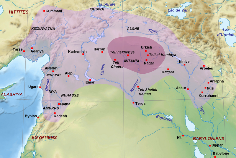
English: Map of the kingdom of Mitanni at its maximal extension, with the main cities and archaeological sites. Adapted from F. Joannès (dir.), Dictionnaire de la civilisation mésopotamienne, Paris, 2001, p. 534 (map by M. Sauvage and B. Lion), and M. Roaf, Cultural Atlas of Mesopotamia and the Ancient Near East, Oxford, 2004, p. 134 with the addition of Terqa among the vassals of Mitanni. Dark purple : the mitannian heartland ; light purple : the approximate maximal extension of the mitannian dominion.
Français : Carte du royaume du Mitanni avec ses limites approximatives à son apogée avec les principales villes et sites archéologiques. Adapté de F. Joannès (dir.), Dictionnaire de la civilisation mésopotamienne, Paris, 2001, p. 534 (carte de M. Sauvage et B. Lion), et M. Roaf, Cultural Atlas of Mesopotamia and the Ancient Near East, Oxford, 2004, p. 134, avec l'ajout de Terqa parmi les vassaux du Mitanni. Mauve foncé : le cœur du Mitanni ; mauve clair : les limites approximatives de l'extension maximale de la domination du Mitanni au début du XVe siècle av. J.-C. |
| تریخ | (UTC) |
| سروت | |
| لکھاری |
|
| دوجے ورژن |
[]
|


| This is a retouched picture, which means that it has been digitally altered from its original version. Modifications: Ajout des sites du Mitanni et de l'étendue du royaume. The original can be viewed here: Near East topographic map-blank.svg:
|
میں، اس کم دے کاپیرائٹ دا مالک، اس کم نوں اس لائسنس دے مطابق چھاپدا واں:
ایہ فائل ایس لسنس Creative Commons Attribution-Share Alike 3.0 Unported, 2.5 Generic, 2.0 Generic and 1.0 Generic نال چلدی اے۔
- تہانوں کھلھ اے:
- حصہ کرنا – کاپی، ونڈنا تے کم بھیجنا
- فیر رلانا – کم نوں فٹ کرنا
- تھلے دتیاں شرطاں نال:
- کس دے ناں – تسیں لازمی ایس کم دے بناں والے بارے دسو جنج اونے آکھیا اے یا جنج لسنس چ آکھیا گیا ہے۔
- اکو جہا شئیر کرو۔ – اگر تسیں بدلدے یا ایس کم تے بناندے تے بنن والے کم نوں اینج دے لسنس نال ای ونڈو گے۔

|
کاپی کرن، ونڈن تے بدلن دی ایس ڈوکومنٹ لئی اجازت دتی جاندی اے ایہناں GNU Free Documentation License, Version 1.2 شرطاں نال یا مگروں کسے وی چھپے ورین Free Software Foundation توں بنا کسے انویرینٹ سیکشن دے، ناں فرنٹ کور لکھت تے ناں بیک کور لکھت دے۔ لسنس دی اک کاپی سیکشن وچ ہیگی اے جہدا ناں اے GNU Free Documentation License۔ |
تسیں اپنی مرضی دا لائسنس چݨ سکدے اوہ۔
پہلا اپلوڈ دا ریکارڈ
This image is a derivative work of the following images:
- File:Near_East_topographic_map-blank.svg licensed with Cc-by-sa-3.0,2.5,2.0,1.0, GFDL
- 2009-08-18T18:31:37Z Sémhur 2425x1581 (2442670 Bytes) 3 - New try
- 2009-08-17T15:39:22Z Sémhur 2425x1581 (1815374 Bytes) 2 - With the background...
- 2009-08-17T15:37:36Z Sémhur 2425x1581 (2836 Bytes) {{Information |Description={{en|1=Blank physical map of the [[:en:Near East|Near East]]}} {{fr|1=Carte physique vierge du [[:fr:Proche-Orient|Proche-Orient]].}} |Source={{own}} |Author=[[User:Sémhur|Sémhur]] |Date=2008-08-1
Uploaded with derivativeFX
فائل دی تریخ
فائل نو اس ویلے دی حالت وچ ویکھن واسطے تاریخ/ویلے تے کلک کرو۔
| تریخ تے ویلہ | نکی مورت | پاسے | ورتن والا | تیپّݨی کرو | |
|---|---|---|---|---|---|
| موجودہ | ۱۹:۰۰, ۲۳ ستمبر ۲۰۱۰ | | ۱,۲۷۲ × ۸۴۹ (۱.۵۱ میگابائٹ) | Zunkir | Ajout de Qattara, corrections mineures. |
| ۱۸:۵۷, ۲۳ ستمبر ۲۰۱۰ |  | ۱,۲۷۲ × ۸۴۹ (۱.۵۱ میگابائٹ) | Zunkir | Coloriage de l'extension du Mitanni, et de sa région centrale, ajout de villes et des noms des cours d'eau. | |
| ۱۶:۴۹, ۲۱ ستمبر ۲۰۱۰ |  | ۱,۱۷۳ × ۷۹۷ (۱.۴۲ میگابائٹ) | Zunkir | {{Information |Description={{en|1=Map of the kingdom of Mitanni at its maximal extension, with the main cities and archeological sites.}} {{fr|Carte du royaume du Mitanni à son apogée avec les principales villes et sites archéologiques.}} |Source=*[[: |
فائل دی ورتوں
تھلے دتے گئے 1 صفحے اس فائل نال جُڑدے نیں
فائل ویاپک ورتوں
ایہہ دوجے وکیاں ایس فائل نوں ورتدے نیں –
- am.wikipedia.org تے ورتوں
- ar.wikipedia.org تے ورتوں
- arz.wikipedia.org تے ورتوں
- ast.wikipedia.org تے ورتوں
- ba.wikipedia.org تے ورتوں
- be-tarask.wikipedia.org تے ورتوں
- bg.wikipedia.org تے ورتوں
- bn.wikipedia.org تے ورتوں
- br.wikipedia.org تے ورتوں
- ceb.wikipedia.org تے ورتوں
- ckb.wikipedia.org تے ورتوں
- cs.wikipedia.org تے ورتوں
- de.wikipedia.org تے ورتوں
- el.wikipedia.org تے ورتوں
- en.wikipedia.org تے ورتوں
- eo.wikipedia.org تے ورتوں
- fa.wikipedia.org تے ورتوں
- fi.wikipedia.org تے ورتوں
- fr.wikipedia.org تے ورتوں
- gl.wikipedia.org تے ورتوں
- hi.wikipedia.org تے ورتوں
- id.wikipedia.org تے ورتوں
- it.wikipedia.org تے ورتوں
- ja.wikipedia.org تے ورتوں
- lt.wikipedia.org تے ورتوں
- lv.wikipedia.org تے ورتوں
- ne.wikipedia.org تے ورتوں
- nl.wikipedia.org تے ورتوں
ایس فائل دا ویکھو ہور جگت ورتن .