فائل:Zealandia topography.jpg

ایس وکھالے دا ناپ: ۵۱۶ × ۶۰۰ پکسلز۔ دوجے ریزولوشنز: ۲۰۶ × ۲۴۰ پکسلز | ۴۱۳ × ۴۸۰ پکسلز | ۶۶۱ × ۷۶۸ پکسلز | ۸۸۱ × ۱,۰۲۴ پکسلز | ۱,۳۹۱ × ۱,۶۱۷ پکسلز ۔
اصل فائل (۱,۳۹۱ × ۱,۶۱۷ پکسلز, فائل حجم: ۱.۳۴ میگابائٹ, MIME type: image/jpeg)
خلاصہ
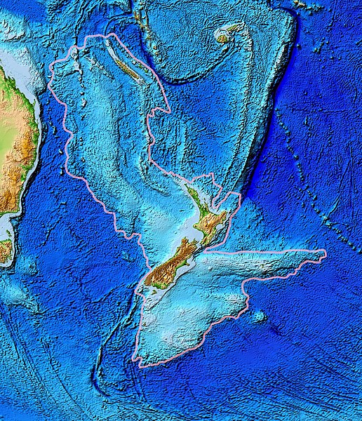
| تفصیل | Topographical map of the Zealandia continent. |
| تریخ | |
| سروت | Ultimate source: ETOPO2v2, a digital database of seafloor and land elevations. Actually cropped from Image:Pacific_elevation.jpg. |
| لکھاری | World Data Center for Geophysics & Marine Geology (Boulder, CO), National Geophysical Data Center, NOAA |
| اجازت (فائل نوں دوبارہ ورتنا) |
NOAA, public domain |
| دوجے ورژن | Image:Pacific_elevation.jpg, here cropped to focus on Zealandia. |
لائسنس –
This image is in the public domain because it contains materials that originally came from the U.S. National Oceanic and Atmospheric Administration, taken or made as part of an employee's official duties.
|
فائل دی تریخ
فائل نو اس ویلے دی حالت وچ ویکھن واسطے تاریخ/ویلے تے کلک کرو۔
| تریخ تے ویلہ | نکی مورت | پاسے | ورتن والا | تیپّݨی کرو | |
|---|---|---|---|---|---|
| موجودہ | ۱۸:۲۴, ۲۸ مارچ ۲۰۱۷ | | ۱,۳۹۱ × ۱,۶۱۷ (۱.۳۴ میگابائٹ) | Bogomolov.PL | continent limits with pink |
| ۰۶:۴۴, ۱۳ مارچ ۲۰۰۷ |  | ۵۷۳ × ۶۷۷ (۱۴۳ کلوبائٹ) | Avenue | == Summary == {{Information |Description=Topographical map of the Zealandia continent. |Source=Source: [http://www.ngdc.noaa.gov/mgg/image/2minrelief.html]. Actually cropped from Image:Pacific_elevation.jpg. |Date=June 2006 |Permissio |
فائل دی ورتوں
تھلے دتے گئے 1 صفحے اس فائل نال جُڑدے نیں
فائل ویاپک ورتوں
ایہہ دوجے وکیاں ایس فائل نوں ورتدے نیں –
- af.wikipedia.org تے ورتوں
- ang.wikipedia.org تے ورتوں
- ar.wikipedia.org تے ورتوں
- ast.wikipedia.org تے ورتوں
- az.wikipedia.org تے ورتوں
- bg.wikipedia.org تے ورتوں
- bn.wikipedia.org تے ورتوں
- ca.wikipedia.org تے ورتوں
- el.wikipedia.org تے ورتوں
- en.wikipedia.org تے ورتوں
- eo.wikipedia.org تے ورتوں
- es.wikipedia.org تے ورتوں
- et.wikipedia.org تے ورتوں
- eu.wikipedia.org تے ورتوں
- fa.wikipedia.org تے ورتوں
- fi.wikipedia.org تے ورتوں
- fr.wikipedia.org تے ورتوں
- gl.wikipedia.org تے ورتوں
- he.wikipedia.org تے ورتوں
- hi.wikipedia.org تے ورتوں
- hr.wikipedia.org تے ورتوں
- hu.wikipedia.org تے ورتوں
- hy.wikipedia.org تے ورتوں
- ia.wikipedia.org تے ورتوں
- id.wikipedia.org تے ورتوں
- incubator.wikimedia.org تے ورتوں
- is.wikipedia.org تے ورتوں
- it.wikipedia.org تے ورتوں
- ja.wikipedia.org تے ورتوں
- ka.wikipedia.org تے ورتوں
- kk.wikipedia.org تے ورتوں
- ko.wikipedia.org تے ورتوں
- li.wikipedia.org تے ورتوں
ایس فائل دا ویکھو ہور جگت ورتن .