فائل:Western Han Mawangdui Silk Map.JPG

ایس وکھالے دا ناپ: ۶۲۱ × ۶۰۰ پکسلز۔ دوجے ریزولوشنز: ۲۴۹ × ۲۴۰ پکسلز | ۴۹۷ × ۴۸۰ پکسلز | ۷۹۵ × ۷۶۸ پکسلز | ۱,۰۶۰ × ۱,۰۲۴ پکسلز | ۲,۱۲۱ × ۲,۰۴۸ پکسلز | ۳,۶۷۵ × ۳,۵۴۹ پکسلز ۔
اصل فائل (۳,۶۷۵ × ۳,۵۴۹ پکسلز, فائل حجم: ۳.۰۷ میگابائٹ, MIME type: image/jpeg)
خلاصہ
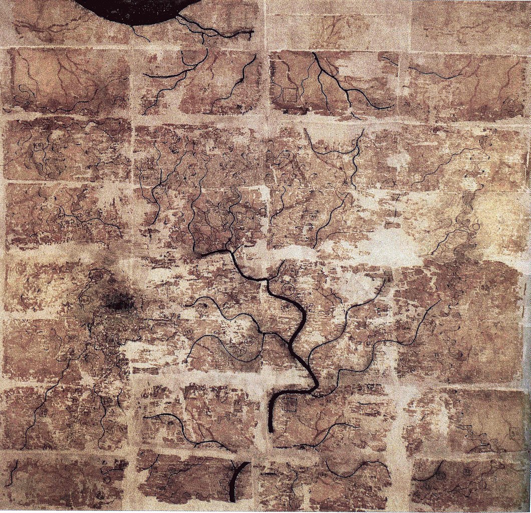
| تفصیل | A Chinese topographic map (with the south positioned at the top) from Mawangdui tomb 3; dated to the early Western Han period (183–168 BC); length is 96 cm; width is 96 cm; the map is made of ink on silk. It is now housed in the Hunan Provincial Museum, Changsha. The map depicts a large territory in southern China spanning from the imperial fiefdom of Changsha (a semi-autonomous kingdom within the Han Empire, now modern-day Hunan) to the independent and sometimes hostile Kingdom of Nanyue in what is now modern-day Guangdong and northern Vietnam. |
| تریخ | 2nd century BC (anywhere from 183 to 168 BC) |
| سروت | Scanned from Barbieri-Low, Anthony J. (2007). Artisans in Early Imperial China. Seattle and London: University of Washington Press. ISBN 0295987138. Page 174. |
| لکھاری | Anonymous ancient Chinese cartographer |
| دوجے ورژن | Derivative works of this file: Cypraea mappa map comparison.jpg |
لائسنس –
|
This is a faithful photographic reproduction of a two-dimensional, public domain work of art. The work of art itself is in the public domain for the following reason:
The official position taken by the Wikimedia Foundation is that "faithful reproductions of two-dimensional public domain works of art are public domain".
This photographic reproduction is therefore also considered to be in the public domain in the United States. In other jurisdictions, re-use of this content may be restricted; see Reuse of PD-Art photographs for details. | ||||
فائل دی تریخ
فائل نو اس ویلے دی حالت وچ ویکھن واسطے تاریخ/ویلے تے کلک کرو۔
| تریخ تے ویلہ | نکی مورت | پاسے | ورتن والا | تیپّݨی کرو | |
|---|---|---|---|---|---|
| موجودہ | ۰۳:۵۸, ۱۱ مئی ۲۰۱۸ | | ۳,۶۷۵ × ۳,۵۴۹ (۳.۰۷ میگابائٹ) | Soerfm | Brightness, color, crop. |
| ۰۳:۱۰, ۲۸ اپریل ۲۰۰۹ |  | ۳,۶۷۵ × ۳,۵۴۹ (۲.۸۹ میگابائٹ) | PericlesofAthens | {{Information |Description=A Chinese topographic map (with the south positioned at the top) from Mawangdui tomb 3; dated to the early Western Han period (183–168 BC); length is 96 cm; width is 96 cm; the map is made of ink on silk. It is now housed |
فائل دی ورتوں
تھلے دتے گئے 1 صفحے اس فائل نال جُڑدے نیں
فائل ویاپک ورتوں
ایہہ دوجے وکیاں ایس فائل نوں ورتدے نیں –
- als.wikipedia.org تے ورتوں
- ca.wikipedia.org تے ورتوں
- de.wikipedia.org تے ورتوں
- en.wikipedia.org تے ورتوں
- es.wikipedia.org تے ورتوں
- fi.wikipedia.org تے ورتوں
- fr.wikipedia.org تے ورتوں
- hr.wikipedia.org تے ورتوں
- id.wikipedia.org تے ورتوں
- it.wikipedia.org تے ورتوں
- ja.wikipedia.org تے ورتوں
- km.wikipedia.org تے ورتوں
- ko.wikipedia.org تے ورتوں
- mwl.wikipedia.org تے ورتوں
- nl.wikipedia.org تے ورتوں
- pl.wikipedia.org تے ورتوں
- pt.wikipedia.org تے ورتوں
- ro.wikipedia.org تے ورتوں
- ru.wikipedia.org تے ورتوں
ایس فائل دا ویکھو ہور جگت ورتن .