اصل فائل (ایس وی جی فائل، پکسل:۱,۱۶۱ × ۱,۳۰۶، فائل سائز: ۱.۳۸ میگابائٹ)
ایہ فائل Wikimedia Commons توں اے تے دوجیاں ویونتاں تے وی ورتی جاسکدی اے۔
گل بات اس دے فائل گل بات صفحہ تے تھلے دتی گئی۔
خلاصہ
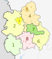
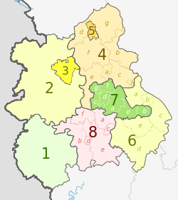
Map
Ceremonial county
Shire county / unitary
Districts
1. Herefordshire U.A.
Shropshire 2. Shropshire U.A.
3. Telford and Wrekin U.A.
Staffordshire 4. Staffordshire †
a ) Cannock Chase , b ) East Staffordshire , c ) Lichfield , d ) Newcastle-under-Lyme , e ) South Staffordshire , f ) Stafford , g ) Staffordshire Moorlands , h ) Tamworth
5. Stoke-on-Trent U.A.
6. Warwickshire †
a ) North Warwickshire , b ) Nuneaton and Bedworth , c ) Rugby , d ) Stratford-on-Avon , e ) Warwick
7. West Midlands *
a ) Birmingham , b ) Coventry , c ) Dudley , d ) Sandwell , e ) Solihull , f ) Walsall , g ) Wolverhampton
8. Worcestershire †
a ) Bromsgrove , b ) Malvern Hills , c ) Redditch , d ) Worcester , e ) Wychavon , f ) Wyre Forest
Key: †shire county | *metropolitan county
لائسنس – کس دے ناں: Dr Greg and Nilfanion. Contains Ordnance Survey data © Crown copyright and database right 2011
تہانوں کھلھ اے:
حصہ کرنا – کاپی، ونڈنا تے کم بھیجنافیر رلانا – کم نوں فٹ کرنا
تھلے دتیاں شرطاں نال:
کس دے ناں – تسیں لازمی ایس کم دے بناں والے بارے دسو جنج اونے آکھیا اے یا جنج لسنس چ آکھیا گیا ہے۔اکو جہا شئیر کرو۔ – اگر تسیں بدلدے یا ایس کم تے بناندے تے بنن والے کم نوں اینج دے لسنس نال ای ونڈو گے۔ https://creativecommons.org/licenses/by-sa/3.0 CC BY-SA 3.0 Creative Commons Attribution-Share Alike 3.0 true true پہلا اپلوڈ دا ریکارڈ This image is a derivative work of the following images:
File:West_Midlands_districts_2011_map.svg licensed with Cc-by-sa-3.0, GFDL
2011-05-01T19:06:46Z Nilfanion 1161x1306 (1392730 Bytes) == Summary == {{Information |Description=Map of the [[w:West Midlands|West Midlands]] region showing the administrative districts. Equirectangular map projection on WGS 84 datum, with N/S stretched 165% Geographic limits: * File:English_ceremonial_counties_2010.svg licensed with Cc-by-sa-3.0, GFDL
2010-11-23T16:39:55Z Nilfanion 1108x1345 (308868 Bytes) thicker lines
2010-11-23T16:20:19Z Nilfanion 1108x1345 (301520 Bytes) tweaks
2010-10-26T20:34:20Z Nilfanion 817x990 (1391832 Bytes) {{Information |Description=Map showing the [[w:ceremonial counties of England]] including the City of London, in 2010. Equirectangular map projection on WGS 84 datum, with N/S stretched 170% Geographic limits: *West: 6.75W Uploaded with derivativeFX
پنجابی Add a one-line explanation of what this file represents
فائل دی تریخ
فائل نو اس ویلے دی حالت وچ ویکھن واسطے تاریخ/ویلے تے کلک کرو۔
تریخ تے ویلہ نکی مورت پاسے ورتن والا تیپّݨی کرو موجودہ ۰۱:۰۱, ۶ مئی ۲۰۱۲ ۱,۱۶۱ × ۱,۳۰۶ (۱.۳۸ میگابائٹ) Dr Greg lighten black boundary line ۰۲:۱۹, ۳ مئی ۲۰۱۲ ۱,۱۶۱ × ۱,۳۰۶ (۱.۳۸ میگابائٹ) Dr Greg == {{int:filedesc}} == {{Information |Description={{en|Map of the West Midlands region of England, showing its counties and administrative districts. The county colours are the same as those in [[:File:English metropolitan ...
فائل دی ورتوں
تھلے دتے گئے 1 صفحے اس فائل نال جُڑدے نیں
فائل ویاپک ورتوں
ایہہ دوجے وکیاں ایس فائل نوں ورتدے نیں –
ar.wikipedia.org تے ورتوں
bar.wikipedia.org تے ورتوں
de.wikipedia.org تے ورتوں
en.wikipedia.org تے ورتوں
fa.wikipedia.org تے ورتوں
frr.wikipedia.org تے ورتوں
fr.wikipedia.org تے ورتوں
hr.wikipedia.org تے ورتوں
hu.wikipedia.org تے ورتوں
mr.wikipedia.org تے ورتوں
pl.wikipedia.org تے ورتوں
pt.wikipedia.org تے ورتوں
th.wikipedia.org تے ورتوں
tr.wikipedia.org تے ورتوں
ur.wikipedia.org تے ورتوں
vec.wikipedia.org تے ورتوں
vi.wikipedia.org تے ورتوں
vls.wikipedia.org تے ورتوں
zh-yue.wikipedia.org تے ورتوں


