فائل:USA territorial growth.gif

ایس وکھالے دا ناپ: ۸۰۰ × ۴۹۸ پکسلز۔ دوجے ریزولوشنز: ۳۲۰ × ۱۹۹ پکسلز | ۶۴۰ × ۳۹۸ پکسلز | ۹۲۱ × ۵۷۳ پکسلز ۔
اصل فائل (۹۲۱ × ۵۷۳ پکسلز, فائل حجم: ۲.۰۱ میگابائٹ, MIME type: image/gif، لوپڈ، ۱۰ فریمز، ۵۰ سیکنڈ)
خلاصہ
| تفصیل |
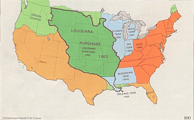
English: US territorial growth 1810–1920, based on the PD USGS maps in Category:Territorial growth maps of the United States.
See key below for explanation of colors.  |
||||||
| سروت |
|
||||||
| لکھاری |
|
||||||
| دوجے ورژن |
|

لائسنس –
This image is in the public domain in the United States because it only contains materials that originally came from the United States Geological Survey, an agency of the United States Department of the Interior. For more information, see the official USGS copyright policy.
|
فائل دی تریخ
فائل نو اس ویلے دی حالت وچ ویکھن واسطے تاریخ/ویلے تے کلک کرو۔
| تریخ تے ویلہ | نکی مورت | پاسے | ورتن والا | تیپّݨی کرو | |
|---|---|---|---|---|---|
| موجودہ | ۰۶:۳۹, ۳۱ مئی ۲۰۰۶ | | ۹۲۱ × ۵۷۳ (۲.۰۱ میگابائٹ) | Roke~commonswiki | longer interval, 3 seconds --> 5 seconds |
| ۱۷:۲۱, ۳۰ مئی ۲۰۰۶ |  | ۹۲۱ × ۵۷۳ (۲.۶۷ میگابائٹ) | Roke~commonswiki | US territorial growth 1810-1920, based on the USGS maps in commons:Category:USA Territorial Growth Maps, put together in Corel Painter IX. The individual maps have this licence: {{PD-USGov-USGS}} If it is necessary for me to licence my contributio |
فائل دی ورتوں
تھلے دتے گئے 1 صفحے اس فائل نال جُڑدے نیں
فائل ویاپک ورتوں
ایہہ دوجے وکیاں ایس فائل نوں ورتدے نیں –
- bn.wikipedia.org تے ورتوں
- en.wikipedia.org تے ورتوں
- es.wikipedia.org تے ورتوں
- fa.wikipedia.org تے ورتوں
- fy.wikipedia.org تے ورتوں
- ha.wikipedia.org تے ورتوں
- he.wikipedia.org تے ورتوں
- nl.wikipedia.org تے ورتوں
- ru.wikipedia.org تے ورتوں
- ru.wikinews.org تے ورتوں
- sr.wikipedia.org تے ورتوں
- tr.wikipedia.org تے ورتوں
- ur.wikipedia.org تے ورتوں
- uz.wikipedia.org تے ورتوں
- www.wikidata.org تے ورتوں