فائل:Sulawesi map.PNG

ایس وکھالے دا ناپ: ۵۴۳ × ۵۹۹ پکسلز۔ دوجے ریزولوشنز: ۲۱۷ × ۲۴۰ پکسلز | ۴۳۵ × ۴۸۰ پکسلز | ۶۹۶ × ۷۶۸ پکسلز | ۹۲۸ × ۱,۰۲۴ پکسلز | ۱,۴۹۲ × ۱,۶۴۷ پکسلز ۔
اصل فائل (۱,۴۹۲ × ۱,۶۴۷ پکسلز, فائل حجم: ۸۳ کلوبائٹ, MIME type: image/png)
خلاصہ
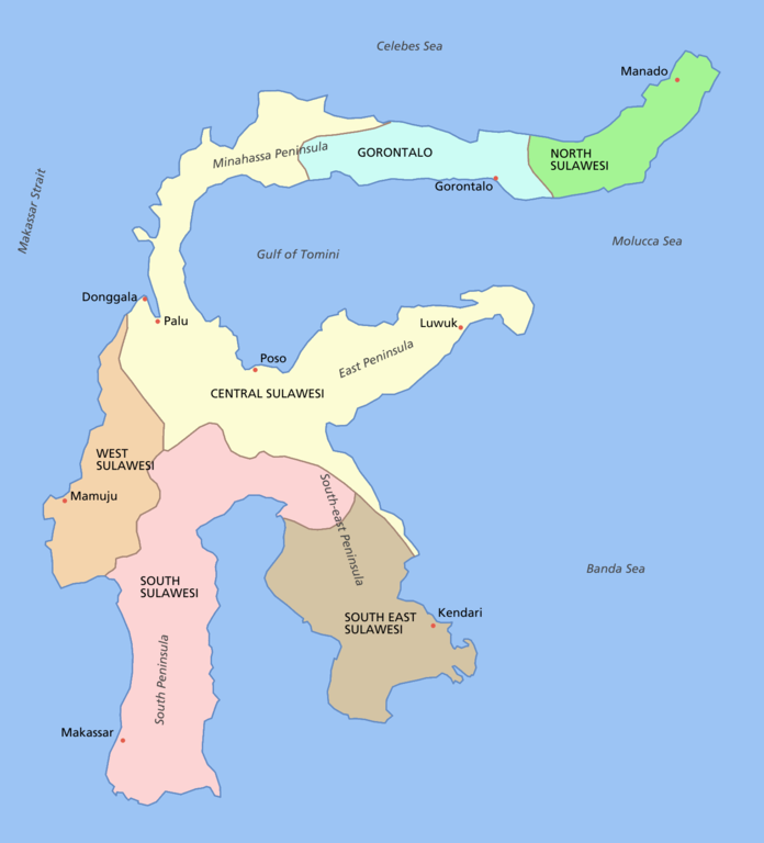
Sulawesi showing provinces, their capital cities, a few other cities and some surrounding areas of water. Note that there are other islands in this area which are not shown as this is a map of Sulawesi island itself.
For a blank map see Image:Sulawesi blank.PNG
derivative works
Derivative works of this file: Sulawesi map id.png
لائسنس –

|
کاپی کرن، ونڈن تے بدلن دی ایس ڈوکومنٹ لئی اجازت دتی جاندی اے ایہناں GNU Free Documentation License, Version 1.2 شرطاں نال یا مگروں کسے وی چھپے ورین Free Software Foundation توں بنا کسے انویرینٹ سیکشن دے، ناں فرنٹ کور لکھت تے ناں بیک کور لکھت دے۔ لسنس دی اک کاپی سیکشن وچ ہیگی اے جہدا ناں اے GNU Free Documentation License۔ |
| ایس فائل نوں کریٹو کامنز Attribution 2.5 پولینڈ لائسنس دتا گیا. | ||
| ||
| اس لائسنس دا ٹیگ GFDL دے مطابق اس فائل چ پایا گیا اے licensing update۔ |
فائل دی تریخ
فائل نو اس ویلے دی حالت وچ ویکھن واسطے تاریخ/ویلے تے کلک کرو۔
| تریخ تے ویلہ | نکی مورت | پاسے | ورتن والا | تیپّݨی کرو | |
|---|---|---|---|---|---|
| موجودہ | ۱۷:۱۱, ۱۱ مارچ ۲۰۰۶ | | ۱,۴۹۲ × ۱,۶۴۷ (۸۳ کلوبائٹ) | Roke~commonswiki | fixed borders of provinces |
| ۰۹:۵۵, ۱۱ مارچ ۲۰۰۶ |  | ۱,۴۹۲ × ۱,۶۴۷ (۸۲ کلوبائٹ) | Roke~commonswiki | Sulawesi showing provinces, their capital cities, a few other cities and some surrounding areas of water. Note that there are other islands in this area which are not shown as this is a map of Sulawesi island itself. Category:Sulawesi [[Category:Maps |
فائل دی ورتوں
اس فائل نال جڑیا کوئی صفحہ نئیں۔
فائل ویاپک ورتوں
ایہہ دوجے وکیاں ایس فائل نوں ورتدے نیں –
- af.wikipedia.org تے ورتوں
- bg.wikipedia.org تے ورتوں
- bn.wikipedia.org تے ورتوں
- bug.wikipedia.org تے ورتوں
- ca.wikipedia.org تے ورتوں
- ceb.wikipedia.org تے ورتوں
- cs.wikipedia.org تے ورتوں
- cy.wikipedia.org تے ورتوں
- el.wikipedia.org تے ورتوں
- en.wikipedia.org تے ورتوں
- es.wikipedia.org تے ورتوں
- eu.wikipedia.org تے ورتوں
- fa.wikipedia.org تے ورتوں
- fi.wikipedia.org تے ورتوں
- fr.wikipedia.org تے ورتوں
- ga.wikipedia.org تے ورتوں
- gl.wikipedia.org تے ورتوں
- gl.wiktionary.org تے ورتوں
- hi.wikipedia.org تے ورتوں
- hu.wikipedia.org تے ورتوں
- id.wiktionary.org تے ورتوں
- ilo.wikipedia.org تے ورتوں
- is.wikipedia.org تے ورتوں
- it.wikipedia.org تے ورتوں
- ja.wikipedia.org تے ورتوں
- kk.wikipedia.org تے ورتوں
- km.wikipedia.org تے ورتوں
- la.wikipedia.org تے ورتوں
- map-bms.wikipedia.org تے ورتوں
- mi.wikipedia.org تے ورتوں
- ml.wikipedia.org تے ورتوں
- mrj.wikipedia.org تے ورتوں
ایس فائل دا ویکھو ہور جگت ورتن .