فائل:Population density of Africa.jpg
ایس وکھالے دا ناپ: ۶۵۰ × ۶۰۰ پکسلز۔ دوجے ریزولوشنز: ۲۶۰ × ۲۴۰ پکسلز | ۵۲۰ × ۴۸۰ پکسلز | ۷۳۸ × ۶۸۱ پکسلز ۔
اصل فائل (۷۳۸ × ۶۸۱ پکسلز, فائل حجم: ۸۴ کلوبائٹ, MIME type: image/jpeg)


خلاصہ
| تفصیل |
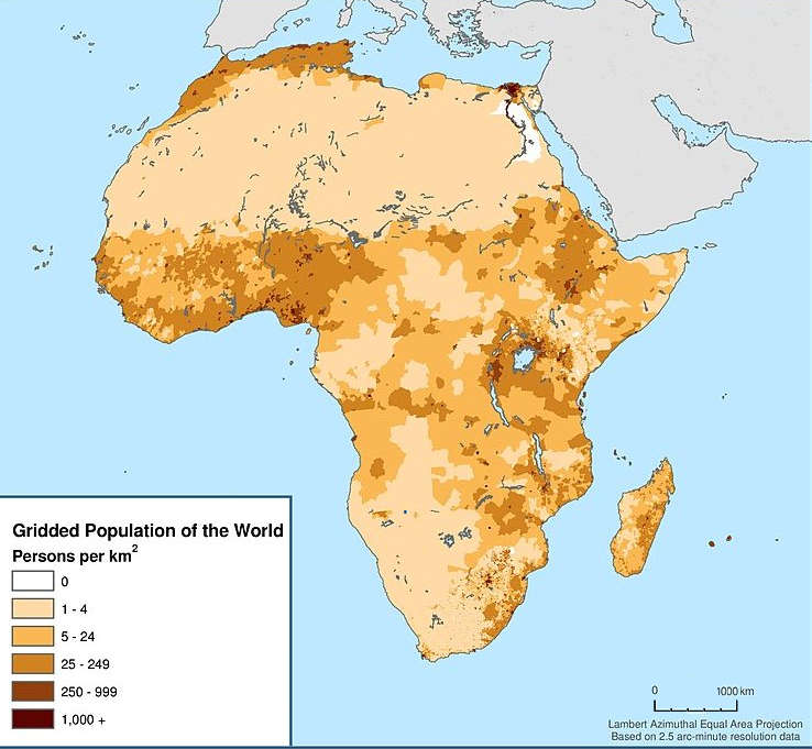
English: Map showing the population density of Africa. Title: Africa: Population Density, 2000 |
| تریخ | |
| سروت | http://sedac.ciesin.columbia.edu/data/set/gpw-v3-population-density/maps |
| لکھاری |
Center for International Earth Science Information Network - CIESIN - Columbia University, International Food Policy Research Institute - IFPRI, The World Bank, and Centro Internacional de Agricultura Tropical - CIAT. 2011. Global Rural-Urban Mapping Project, Version 1 (GRUMPv1): Urban Extents Grid (Africa). Palisades, NY: NASA Socioeconomic Data and Applications Center (SEDAC). http://sedac.ciesin.columbia.edu/data/set/grump-v1-urban-extents/maps. Accessed 12 October 2017. Source: Center for International Earth Science Information Network (CIESIN), Columbia University; and Centro Internacional de Agricultura Tropical (CIAT), Gridded Population of the World (GPW), Version 3. Palisades, NY: CIESIN, Columbia University. Available at: http://sedac.ciesin.columbia.edu/gpw." |
| اجازت (فائل نوں دوبارہ ورتنا) |
CC BY 3.0. See the previous versions of this file. |
لائسنس –
ایس فائل نوں کریٹو کامنز Attribution 3.0 انپورٹڈ لائسنس دتا گیا.
- تہانوں کھلھ اے:
- حصہ کرنا – کاپی، ونڈنا تے کم بھیجنا
- فیر رلانا – کم نوں فٹ کرنا
- تھلے دتیاں شرطاں نال:
- کس دے ناں – تسیں لازمی ایس کم دے بناں والے بارے دسو جنج اونے آکھیا اے یا جنج لسنس چ آکھیا گیا ہے۔
فائل دی تریخ
فائل نو اس ویلے دی حالت وچ ویکھن واسطے تاریخ/ویلے تے کلک کرو۔
| تریخ تے ویلہ | نکی مورت | پاسے | ورتن والا | تیپّݨی کرو | |
|---|---|---|---|---|---|
| موجودہ | ۲۰:۰۲, ۱۸ دسمبر ۲۰۱۷ | | ۷۳۸ × ۶۸۱ (۸۴ کلوبائٹ) | Maproom | Removed credits, logos, etc. Lengthened scale. |
| ۱۲:۴۵, ۱۲ دسمبر ۲۰۱۷ |  | ۷۳۸ × ۹۸۹ (۱۳۱ کلوبائٹ) | ديفيد عادل وهبة خليل 2 | Removed border by cropping 7 % horizontally and 3 % vertically using CropTool with precise mode. | |
| ۲۰:۲۸, ۱۲ اکتوبر ۲۰۱۷ |  | ۷۹۱ × ۱,۰۲۴ (۱۲۹ کلوبائٹ) | Mrmisr | User created page with UploadWizard |
فائل دی ورتوں
تھلے دتے گئے 1 صفحے اس فائل نال جُڑدے نیں
فائل ویاپک ورتوں
ایہہ دوجے وکیاں ایس فائل نوں ورتدے نیں –
- en.wikipedia.org تے ورتوں
- ha.wikipedia.org تے ورتوں
- ur.wikipedia.org تے ورتوں
- vi.wikipedia.org تے ورتوں