فائل:Pakistan Nationalhighways.PNG

ایس وکھالے دا ناپ: ۶۲۵ × ۶۰۰ پکسلز۔ دوجے ریزولوشنز: ۲۵۰ × ۲۴۰ پکسلز | ۵۰۰ × ۴۸۰ پکسلز | ۸۰۰ × ۷۶۸ پکسلز | ۱,۰۶۷ × ۱,۰۲۴ پکسلز | ۲,۱۳۴ × ۲,۰۴۸ پکسلز | ۳,۲۵۶ × ۳,۱۲۵ پکسلز ۔
اصل فائل (۳,۲۵۶ × ۳,۱۲۵ پکسلز, فائل حجم: ۱.۰۹ میگابائٹ, MIME type: image/png)

|
This map image could be re-created using vector graphics as an SVG file. This has several advantages; see Commons:Media for cleanup for more information. If an SVG form of this image is available, please upload it and afterwards replace this template with
{{vector version available|new image name}}.
It is recommended to name the SVG file “Pakistan Nationalhighways.svg”—then the template Vector version available (or Vva) does not need the new image name parameter. |
خلاصہ
| تفصیل |
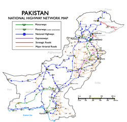
English: National Highways, Motorways & Strategic Roads in Pakistan. (Longest route N-5, from Karachi to Torkham, covering cities of Hyderabad, Multan, Lahore, Rawalpindi and Peshawar with a total length of 1,756 kilometers.) Русский: Схема национальных автодорог, автомагистралей и стратегических дорог Пакистана |
| تریخ | Uploaded in June 2009 by Nomi887; modified in July 2009 by Brainlara73. |
| سروت | The English language Wikipedia. Original text: Self made using [1] and [2] as reference. |
| لکھاری | Original text: nomi887 (talk) |
![[1]](http://www.daleelteq.com.pk/images/maps/Highway%20&%20Motorway%20Network%20of%20Pakistan.jpg)
لائسنس –
ایس فائل نوں کریٹو کامنز Attribution 2.5 پولینڈ لائسنس دتا گیا.
کس دے ناں: Nomi887
- تہانوں کھلھ اے:
- حصہ کرنا – کاپی، ونڈنا تے کم بھیجنا
- فیر رلانا – کم نوں فٹ کرنا
- تھلے دتیاں شرطاں نال:
- کس دے ناں – تسیں لازمی ایس کم دے بناں والے بارے دسو جنج اونے آکھیا اے یا جنج لسنس چ آکھیا گیا ہے۔
- اکو جہا شئیر کرو۔ – اگر تسیں بدلدے یا ایس کم تے بناندے تے بنن والے کم نوں اینج دے لسنس نال ای ونڈو گے۔
پہلا اپلوڈ دا ریکارڈ
All usernames refer to en:Wikipedia (log):
- 11:08, 7 July 2009 Brainlara73 uploaded a new version of "File:Pakistan Nationalhighways.PNG" 1,354×1,316 (246 KB) (Added some more locations in punjab.)
- 04:53, 17 June 2009 Nomi887 uploaded "File:Pakistan Nationalhighways.PNG" 1,354×1,316 (292 KB) ({{Information |Description = National Highways, Motorways & Strategic Roads in Pakistan |Source = Self made using [http://www.daleelteq.com.pk/images/maps/Highway%20&%20Motorway%20Network%20of%20Pakistan.jpg] and [http://www.nhmp.gov.pk/mapm.)
فائل دی تریخ
فائل نو اس ویلے دی حالت وچ ویکھن واسطے تاریخ/ویلے تے کلک کرو۔
| تریخ تے ویلہ | نکی مورت | پاسے | ورتن والا | تیپّݨی کرو | |
|---|---|---|---|---|---|
| موجودہ | ۲۰:۱۸, ۱ جنوری ۲۰۱۹ | | ۳,۲۵۶ × ۳,۱۲۵ (۱.۰۹ میگابائٹ) | Pakieditor | Reverted to version as of 12:05, 26 June 2012 (UTC) |
| ۲۰:۱۵, ۱ جنوری ۲۰۱۹ |  | ۱,۱۲۵ × ۱,۰۸۰ (۵۵۳ کلوبائٹ) | Pakieditor | More detailed map. | |
| ۱۷:۰۵, ۲۶ جون ۲۰۱۲ |  | ۳,۲۵۶ × ۳,۱۲۵ (۱.۰۹ میگابائٹ) | Nomi887 | Corrected. | |
| ۱۴:۵۱, ۱۴ فروری ۲۰۱۱ |  | ۱,۳۵۴ × ۱,۳۱۶ (۳۲۶ کلوبائٹ) | Nomi887 | Minor corrections | |
| ۱۴:۴۰, ۱۴ فروری ۲۰۱۱ |  | ۱,۳۵۴ × ۱,۳۱۶ (۳۲۵ کلوبائٹ) | Nomi887 | Added Expressways & logos. | |
| ۰۵:۰۰, ۷ جنوری ۲۰۱۰ |  | ۱,۳۵۴ × ۱,۳۱۶ (۲۴۶ کلوبائٹ) | Guillaume70 | {{Information |Description=National Highways, Motorways & Strategic Roads in Pakistan. (Longest route N-5, from Karachi to Torkham, covering cities of Hyderabad, Multan, Lahore, Rawalpindi and Peshawar with a total length of 1819 kilometers.) |Source=Wiki |
فائل دی ورتوں
تھلے دتے گئے 2 صفحے اس فائل نال جُڑدے نیں
فائل ویاپک ورتوں
ایہہ دوجے وکیاں ایس فائل نوں ورتدے نیں –
- bn.wikipedia.org تے ورتوں
- cs.wikipedia.org تے ورتوں
- de.wikipedia.org تے ورتوں
- de.wikivoyage.org تے ورتوں
- en.wikipedia.org تے ورتوں
- Transport in Pakistan
- Controlled-access highway
- Indus Highway
- National highways of Pakistan
- N-5 National Highway
- Motorways of Pakistan
- N-25 National Highway
- User:Nomi887
- Expressways of Pakistan
- N-50 National Highway
- N-30 National Highway
- N-40 National Highway
- N-45 National Highway
- N-65 National Highway
- N-70 National Highway
- N-75 National Highway
- N-85 National Highway
- N-80 National Highway
- N-90 National Highway
- N-95 National Highway
- N-105 National Highway
- N-110 National Highway
- N-120 National Highway
- N-125 National Highway
- N-155 National Highway
- N-255 National Highway
- N-305 National Highway
- N-455 National Highway
- N-655 National Highway
- Roads in Pakistan
- Template talk:Portal/Archive 8
- en.wikivoyage.org تے ورتوں
- eo.wikipedia.org تے ورتوں
ایس فائل دا ویکھو ہور جگت ورتن .