فائل:North East England counties 2009 map.svg

Size of this PNG preview of this SVG file: ۴۸۲ × ۵۹۹ پکسلز. دوجے ریزولوشنز: ۱۹۳ × ۲۴۰ پکسلز | ۳۸۶ × ۴۸۰ پکسلز | ۶۱۸ × ۷۶۸ پکسلز | ۸۲۴ × ۱,۰۲۴ پکسلز | ۱,۶۴۷ × ۲,۰۴۸ پکسلز | ۱,۰۸۲ × ۱,۳۴۵ پکسلز ۔
اصل فائل (ایس وی جی فائل، پکسل:۱,۰۸۲ × ۱,۳۴۵، فائل سائز: ۷۲۳ کلوبائٹ)
خلاصہ
| تفصیل |
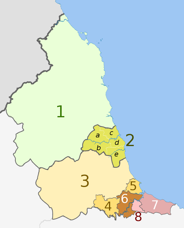
English: Map of the North East England region of England, showing its counties and administrative districts. The county colours are the same as those in File:English metropolitan and non-metropolitan counties 2009.svg.
Equirectangular map projection on WGS 84 datum, with N/S stretched 170% Geographic limits:
|
| تریخ | (UTC) |
| سروت |
This file was derived from: |
| لکھاری |
|
| دوجے ورژن |
 |


| Map | Ceremonial county | Unitary authority | Metropolitan districts |
|---|---|---|---|
 |
1. Northumberland | ||
| 2. Tyne and Wear metropolitan county |
a) Newcastle upon Tyne, b) Gateshead, c) North Tyneside, d) South Tyneside, e) Sunderland | ||
| Durham | 3. Durham | ||
| 4. Darlington | |||
| 5. Hartlepool | |||
| 6. Stockton-on-Tees | |||
| North Yorkshire (part only) | |||
| 7. Redcar and Cleveland | |||
| 8. Middlesbrough | |||
لائسنس –
ایس فائل نوں کریٹو کامنز Attribution 2.5 پولینڈ لائسنس دتا گیا.
کس دے ناں: Dr Greg and Nilfanion. Contains Ordnance Survey data © Crown copyright and database right 2011
- تہانوں کھلھ اے:
- حصہ کرنا – کاپی، ونڈنا تے کم بھیجنا
- فیر رلانا – کم نوں فٹ کرنا
- تھلے دتیاں شرطاں نال:
- کس دے ناں – تسیں لازمی ایس کم دے بناں والے بارے دسو جنج اونے آکھیا اے یا جنج لسنس چ آکھیا گیا ہے۔
- اکو جہا شئیر کرو۔ – اگر تسیں بدلدے یا ایس کم تے بناندے تے بنن والے کم نوں اینج دے لسنس نال ای ونڈو گے۔
پہلا اپلوڈ دا ریکارڈ
This image is a derivative work of the following images:
- File:North_East_England__districts_2011_map.svg licensed with Cc-by-sa-3.0, GFDL
- 2011-05-01T18:56:43Z Nilfanion 1082x1345 (714062 Bytes) == Summary == {{Information |Description=Map of the [[w:North East England|North East England]] region showing the administrative districts. Equirectangular map projection on WGS 84 datum, with N/S stretched 170% Geographic
- File:English_ceremonial_counties_2010.svg licensed with Cc-by-sa-3.0, GFDL
- 2010-11-23T16:39:55Z Nilfanion 1108x1345 (308868 Bytes) thicker lines
- 2010-11-23T16:20:19Z Nilfanion 1108x1345 (301520 Bytes) tweaks
- 2010-10-26T20:34:20Z Nilfanion 817x990 (1391832 Bytes) {{Information |Description=Map showing the [[w:ceremonial counties of England]] including the City of London, in 2010. Equirectangular map projection on WGS 84 datum, with N/S stretched 170% Geographic limits: *West: 6.75W
Uploaded with derivativeFX
فائل دی تریخ
فائل نو اس ویلے دی حالت وچ ویکھن واسطے تاریخ/ویلے تے کلک کرو۔
| تریخ تے ویلہ | نکی مورت | پاسے | ورتن والا | تیپّݨی کرو | |
|---|---|---|---|---|---|
| موجودہ | ۰۱:۱۶, ۱۵ اگست ۲۰۱۸ | | ۱,۰۸۲ × ۱,۳۴۵ (۷۲۳ کلوبائٹ) | Inops | change letters labelling the boroughs of Tyne and Wearfrom white to black. Hardly intelligible when thumbnailed otherwise |
| ۰۱:۱۱, ۶ مئی ۲۰۱۲ |  | ۱,۰۸۲ × ۱,۳۴۵ (۷۲۳ کلوبائٹ) | Dr Greg | lighten black boundary line | |
| ۰۳:۲۱, ۲ مئی ۲۰۱۲ |  | ۱,۰۸۲ × ۱,۳۴۵ (۷۲۳ کلوبائٹ) | Dr Greg | == {{int:filedesc}} == {{Information |Description={{en|Map of the North East England region of England, showing its counties and administrative districts. The county colours are the same as those in [[:File:English metropolitan... |
فائل دی ورتوں
تھلے دتے گئے 1 صفحے اس فائل نال جُڑدے نیں
فائل ویاپک ورتوں
ایہہ دوجے وکیاں ایس فائل نوں ورتدے نیں –
- ar.wikipedia.org تے ورتوں
- ca.wikipedia.org تے ورتوں
- de.wikipedia.org تے ورتوں
- en.wikipedia.org تے ورتوں
- es.wikipedia.org تے ورتوں
- fa.wikipedia.org تے ورتوں
- fr.wikipedia.org تے ورتوں
- hu.wikipedia.org تے ورتوں
- ja.wikipedia.org تے ورتوں
- mr.wikipedia.org تے ورتوں
- pl.wikipedia.org تے ورتوں
- th.wikipedia.org تے ورتوں
- ur.wikipedia.org تے ورتوں
- vi.wikipedia.org تے ورتوں
- vls.wikipedia.org تے ورتوں
- zh-yue.wikipedia.org تے ورتوں