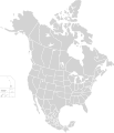
فائل:North America second level political division 2.svg

اصل فائل(ایس وی جی فائل، پکسل:۵۱۲ × ۵۹۶، فائل سائز: ۱۳۲ کلوبائٹ)

ایہ فائل Wikimedia Commons توں اے تے دوجیاں ویونتاں تے وی ورتی جاسکدی اے۔ گل بات اس دے فائل گل بات صفحہ تے تھلے دتی گئی۔

خلاصہ

تفصیل
English: Map of North America and its second-level political divisions. Canadian provinces, US and Mexican states. Canada, Mexico, United States.

Non-contiguous parts of a states/provinces are "grouped" together with the main area of the state/provinces, so any state/provinces can be coloured in completion with one click anywhere on the state/provinces's area.

Also, all states/provinces have a "id" attached to them, making them easy to find. Select "find" and then enter in the state/provinces's ISO 3166-2 code in the "id" field to find it. The codes can be found here (Canada), here (USA) and here (Mexico).
تریخ
سروت

Canada and US map: BlankMap-USA-states-Canada-provinces, HI closer.svg by Lokal_Profil.
Mexico map: Mexico template.svg by Mario Fuente Cid
Combined by Alex Covarrubias.

 
The SVG code is valid.
 
This vector image was created with Inkscape, and then manually edited
.
 
W3C-validity not checked.
لکھاری Alex Covarrubias
اجازت
(فائل نوں دوبارہ ورتنا)
w:en:Creative Commons
کس دے ناں اکو جہا شئیر کرو۔
ایس فائل نوں کریٹو کامنز Attribution 2.5 جنرک لائسنس دتا گیا.
تہانوں کھلھ اے:
  • حصہ کرنا – کاپی، ونڈنا تے کم بھیجنا
  • فیر رلانا – کم نوں فٹ کرنا
تھلے دتیاں شرطاں نال:
  • کس دے ناں – تسیں لازمی ایس کم دے بناں والے بارے دسو جنج اونے آکھیا اے یا جنج لسنس چ آکھیا گیا ہے۔
  • اکو جہا شئیر کرو۔ – اگر تسیں بدلدے یا ایس کم تے بناندے تے بنن والے کم نوں اینج دے لسنس نال ای ونڈو گے۔
دوجے ورژن

Derivative works of this file:

Captions

Add a one-line explanation of what this file represents

Items portrayed in this file

چترن

copyrighted English

۷ اکتوبر 2007

فائل دی تریخ

فائل نو اس ویلے دی حالت وچ ویکھن واسطے تاریخ/ویلے تے کلک کرو۔

تریخ تے ویلہنکی مورتپاسےورتن والاتیپّݨی کرو
موجودہ۰۶:۵۱, ۲۳ نومبر ۲۰۲۰۰۶:۵۱, ۲۳ نومبر ۲۰۲۰ ویلے دے ورژن ساتھ انگوٹھاکار روپ۵۱۲ × ۵۹۶ (۱۳۲ کلوبائٹ)Ponderosapine210Added the prominent islands of Manitoulin (Ontario) and Isle Royale (Michigan) to the Great Lakes.
۰۴:۰۷, ۲ جون ۲۰۱۹۰۴:۰۷, ۲ جون ۲۰۱۹ ویلے دے ورژن ساتھ انگوٹھاکار روپ۵۱۲ × ۵۹۶ (۱۳۰ کلوبائٹ)Fluffy89502added territories, made DC visible, adjusted mexican borders
۱۷:۲۳, ۴ اپریل ۲۰۱۴۱۷:۲۳, ۴ اپریل ۲۰۱۴ ویلے دے ورژن ساتھ انگوٹھاکار روپ۱,۷۱۲ × ۱,۹۹۲ (۲۷۰ کلوبائٹ)Lommesmade the borders between the mexican subdivisions the same size as their canadian / us counterparts.
۰۴:۲۳, ۹ دسمبر ۲۰۰۷۰۴:۲۳, ۹ دسمبر ۲۰۰۷ ویلے دے ورژن ساتھ انگوٹھاکار روپ۱,۷۱۲ × ۱,۹۹۲ (۳۲۷ کلوبائٹ)Lokal ProfilCode cleanup
۱۲:۵۵, ۷ اکتوبر ۲۰۰۷۱۲:۵۵, ۷ اکتوبر ۲۰۰۷ ویلے دے ورژن ساتھ انگوٹھاکار روپ۱,۷۱۲ × ۱,۹۹۲ (۳۴۲ کلوبائٹ)AlexCovarrubias== Summary == {{Information |Description=Map of North America and its second-level political divisions. Canadian provinces, US and Mexican states. Canada, Mexico, United States. |Source=Canada and US map by Alan Rockefeller. Mexico map by Alex Covarrubias

اس فائل نال جڑیا کوئی صفحہ نئیں۔

فائل ویاپک ورتوں

میٹا ڈیٹا