فائل:Map of Constantinople (1422) by Florentine cartographer Cristoforo Buondelmonte.jpg
ایس وکھالے دا ناپ: ۴۷۶ × ۶۰۰ پکسلز۔ دوجے ریزولوشنز: ۱۹۰ × ۲۴۰ پکسلز | ۵۹۲ × ۷۴۶ پکسلز ۔
اصل فائل (۵۹۲ × ۷۴۶ پکسلز, فائل حجم: ۸۳۸ کلوبائٹ, MIME type: image/jpeg)
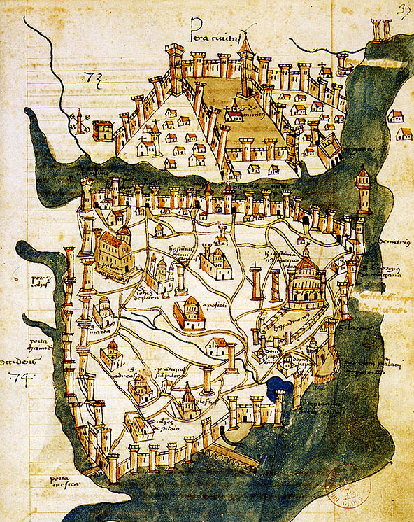
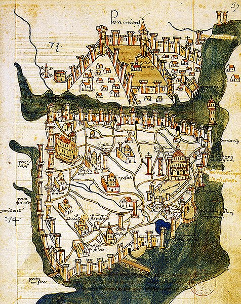
| تفصیل | Map of Constantinople (a small part of modern Istanbul), called "Historic Peninsula", Tarihi Yarımada en Turkish) designed in 1422 by Florentine cartographer Cristoforo Buondelmonti (Description des îles de l'archipel, Bibliothèque nationale, Paris) is the oldest surviving map of the city, and the only surviving map which predates the Turkish conquest of Constantinople in 1453. | ||||
| تریخ | |||||
| سروت | Liber insularum Archipelagi (1824), version available at the Bibliothèque nationale de France, Paris | ||||
| لکھاری | Cristoforo Buondelmonti | ||||
| اجازت (فائل نوں دوبارہ ورتنا) |
|
||||
| دوجے ورژن |
|
||||

_by_Florentine_cartographer_Cristoforo_Buondelmonte.jpg)
فائل دی تریخ
فائل نو اس ویلے دی حالت وچ ویکھن واسطے تاریخ/ویلے تے کلک کرو۔
| تریخ تے ویلہ | نکی مورت | پاسے | ورتن والا | تیپّݨی کرو | |
|---|---|---|---|---|---|
| موجودہ | ۱۵:۲۴, ۲۵ جون ۲۰۰۷ | | ۵۹۲ × ۷۴۶ (۸۳۸ کلوبائٹ) | M.K. | {{Information |Description=Map of Constantinople (1422) by Florentine cartographer Cristoforo Buondelmonte (''Description des îles de l'archipel'', Bibliothèque nationale, Paris) is the oldest surviving map of the city, and the only surviving ma |
فائل دی ورتوں
اس فائل نال جڑیا کوئی صفحہ نئیں۔
فائل ویاپک ورتوں
ایہہ دوجے وکیاں ایس فائل نوں ورتدے نیں –
- ar.wikipedia.org تے ورتوں
- az.wikipedia.org تے ورتوں
- ba.wikipedia.org تے ورتوں
- bg.wikipedia.org تے ورتوں
- ca.wikipedia.org تے ورتوں
- ce.wikipedia.org تے ورتوں
- cs.wikipedia.org تے ورتوں
- de.wikipedia.org تے ورتوں
- el.wikipedia.org تے ورتوں
- en.wikipedia.org تے ورتوں
- Bosporus
- Constantinople
- Constantine XI Palaiologos
- John VII Palaiologos
- Walls of Constantinople
- Beyoğlu
- Maiden's Tower
- Siege of Constantinople (1422)
- Siege of Constantinople (1411)
- Template:Did you know nominations/Kontoskalion
- Piyalepaşa, Beyoğlu
- Wikipedia:Main Page history/2019 February 23
- Siege of Constantinople (1394–1402)
- es.wikipedia.org تے ورتوں
- et.wikipedia.org تے ورتوں
- eu.wikipedia.org تے ورتوں
- fa.wikipedia.org تے ورتوں
- frp.wikipedia.org تے ورتوں
- fr.wikipedia.org تے ورتوں
ایس فائل دا ویکھو ہور جگت ورتن .
_by_Florentine_cartographer_Cristoforo_Buondelmonte.jpg)
_by_Florentine_cartographer_Cristoforo_Buondelmonte.jpg)