فائل:Kargil.map.gif
اس توں وڈی مورت موجود نہیں۔
Kargil.map.gif (۴۲۸ × ۳۹۶ پکسلز, فائل حجم: ۱۱ کلوبائٹ, MIME type: image/gif)

|
This locator map image could be re-created using vector graphics as an SVG file. This has several advantages; see Commons:Media for cleanup for more information. If an SVG form of this image is available, please upload it and afterwards replace this template with
{{vector version available|new image name}}.
It is recommended to name the SVG file “Kargil.map.svg”—then the template Vector version available (or Vva) does not need the new image name parameter. |
This file is a work of a sailor or employee of the U.S. Navy, taken or made as part of that person's official duties. As a work of the U.S. federal government, it is in the public domain in the United States.
|
 | |
| ایہ فائل دے بارے چ دس اے جے اے کاپی حف دیاں روکاں توں کھلی اے تے نالدے رلدے حقاں توں وی۔ | ||
Source: http://www.ccc.nps.navy.mil/research/kargil/index.asp
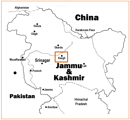
Geo-political location of Kargil.
derivative works
Derivative works of this file:
فائل دی تریخ
فائل نو اس ویلے دی حالت وچ ویکھن واسطے تاریخ/ویلے تے کلک کرو۔
| تریخ تے ویلہ | نکی مورت | پاسے | ورتن والا | تیپّݨی کرو | |
|---|---|---|---|---|---|
| موجودہ | ۱۳:۰۹, ۱۹ اپریل ۲۰۰۷ | | ۴۲۸ × ۳۹۶ (۱۱ کلوبائٹ) | A3A3A3A | {{PD-USGov-Military-Navy}} Source: http://www.ccc.nps.navy.mil/research/kargil/index.asp Geo-political location of Kargil. |
فائل دی ورتوں
تھلے دتے گئے 1 صفحے اس فائل نال جُڑدے نیں
فائل ویاپک ورتوں
ایہہ دوجے وکیاں ایس فائل نوں ورتدے نیں –
- as.wikipedia.org تے ورتوں
- azb.wikipedia.org تے ورتوں
- az.wikipedia.org تے ورتوں
- be-tarask.wikipedia.org تے ورتوں
- be.wikipedia.org تے ورتوں
- bn.wikipedia.org تے ورتوں
- ca.wikipedia.org تے ورتوں
- cs.wikipedia.org تے ورتوں
- en.wikipedia.org تے ورتوں
- es.wikipedia.org تے ورتوں
- fa.wikipedia.org تے ورتوں
- gu.wikipedia.org تے ورتوں
- id.wikipedia.org تے ورتوں
- it.wikipedia.org تے ورتوں
- ka.wikipedia.org تے ورتوں
- kn.wikipedia.org تے ورتوں
- ko.wikipedia.org تے ورتوں
- ml.wikipedia.org تے ورتوں
- ne.wikipedia.org تے ورتوں
- nl.wikipedia.org تے ورتوں
- pt.wikipedia.org تے ورتوں
- ru.wikipedia.org تے ورتوں
- sat.wikipedia.org تے ورتوں
- sd.wikipedia.org تے ورتوں
- sr.wikipedia.org تے ورتوں
- ta.wikipedia.org تے ورتوں
- te.wikipedia.org تے ورتوں
- tr.wikipedia.org تے ورتوں
- uk.wikipedia.org تے ورتوں
- uz.wikipedia.org تے ورتوں
- www.wikidata.org تے ورتوں
- zh.wikipedia.org تے ورتوں