فائل:Jerusalem map Green Line.png
اس توں وڈی مورت موجود نہیں۔
Jerusalem_map_Green_Line.png (۳۲۸ × ۳۷۰ پکسلز, فائل حجم: ۳۵ کلوبائٹ, MIME type: image/png)
خلاصہ
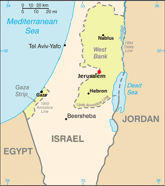
| تفصیل | Map showing Jerusalem straddling the Green Line |
| تریخ | (UTC) |
| سروت | |
| لکھاری |
|
| This is a retouched picture, which means that it has been digitally altered from its original version. Modifications: changed color of WB/Gaza, removed several cities and notes. The original can be viewed here: Cia-is-map2.gif:
|
لائسنس –
This image is in the public domain because it contains materials that originally came from the United States Central Intelligence Agency's World Factbook.
|
 |
پہلا اپلوڈ دا ریکارڈ
This image is a derivative work of the following images:
- File:Cia-is-map2.gif licensed with PD-USGov-CIA-WF
- 2006-08-13T22:27:27Z Milan.sk 330x715 (21389 Bytes)
Uploaded with derivativeFX
فائل دی تریخ
فائل نو اس ویلے دی حالت وچ ویکھن واسطے تاریخ/ویلے تے کلک کرو۔
| تریخ تے ویلہ | نکی مورت | پاسے | ورتن والا | تیپّݨی کرو | |
|---|---|---|---|---|---|
| موجودہ | ۰۱:۲۶, ۹ دسمبر ۲۰۱۱ | | ۳۲۸ × ۳۷۰ (۳۵ کلوبائٹ) | Nableezy | upload under a different file name if you insist |
| ۲۳:۰۱, ۸ دسمبر ۲۰۱۱ |  | ۳۲۸ × ۳۷۰ (۳۷ کلوبائٹ) | Someone35 | fixed | |
| ۲۳:۰۰, ۸ دسمبر ۲۰۱۱ |  | ۳۲۸ × ۳۷۰ (۳۷ کلوبائٹ) | Someone35 | Now there's more contrast between Israel, the West bank and other countries. | |
| ۰۶:۴۰, ۴ دسمبر ۲۰۱۱ |  | ۳۲۸ × ۳۷۰ (۳۵ کلوبائٹ) | Nableezy | reposition scale, label for Mediterranean Sea and Tel Aviv | |
| ۰۳:۱۵, ۴ دسمبر ۲۰۱۱ |  | ۳۲۸ × ۳۷۰ (۳۵ کلوبائٹ) | Nableezy | cropped | |
| ۱۰:۰۸, ۳ دسمبر ۲۰۱۱ |  | ۳۲۸ × ۷۱۵ (۵۷ کلوبائٹ) | Nableezy | Removed Ashqelon, Elat, added Tel Aviv, Gaza, modified dot for Jerusalem and placement and size of word "Jerusalem" | |
| ۲۱:۰۶, ۲ دسمبر ۲۰۱۱ |  | ۳۲۸ × ۷۱۵ (۶۳ کلوبائٹ) | Nableezy | == {{int:filedesc}} == {{Information |Description=Map showing Jerusalem straddling the Green Line |Source=*File:Cia-is-map2.gif |Date=2011-12-02 16:04 (UTC) |Author=*File:Cia-is-map2.gif: CIA *derivative work: ~~~ |Permission= |other_versions= |
فائل دی ورتوں
تھلے دتے گئے 1 صفحے اس فائل نال جُڑدے نیں
فائل ویاپک ورتوں
ایہہ دوجے وکیاں ایس فائل نوں ورتدے نیں –
- en.wikipedia.org تے ورتوں
- es.wikipedia.org تے ورتوں
- lt.wiktionary.org تے ورتوں
- nl.wikipedia.org تے ورتوں
- pt.wikipedia.org تے ورتوں
- tr.wikipedia.org تے ورتوں
- ur.wikipedia.org تے ورتوں