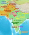
فائل:IndoParthianMap.jpg

ایس وکھالے دا ناپ: ۴۹۸ × ۶۰۰ پکسلز۔ دوجے ریزولوشنز: ۱۹۹ × ۲۴۰ پکسلز | ۳۹۹ × ۴۸۰ پکسلز | ۶۳۸ × ۷۶۸ پکسلز | ۱,۱۹۶ × ۱,۴۴۰ پکسلز ۔
اصل فائل (۱,۱۹۶ × ۱,۴۴۰ پکسلز, فائل حجم: ۲۷۶ کلوبائٹ, MIME type: image/jpeg)
فائل دی تریخ
فائل نو اس ویلے دی حالت وچ ویکھن واسطے تاریخ/ویلے تے کلک کرو۔
| تریخ تے ویلہ | نکی مورت | پاسے | ورتن والا | تیپّݨی کرو | |
|---|---|---|---|---|---|
| موجودہ | ۰۲:۱۷, ۲۷ فروری ۲۰۰۷ |  | ۱,۱۹۶ × ۱,۴۴۰ (۲۷۶ کلوبائٹ) | World Imaging | Better map |
| ۰۱:۱۲, ۲۹ جنوری ۲۰۰۷ |  | ۱,۲۰۰ × ۱,۴۴۰ (۲۷۰ کلوبائٹ) | World Imaging | Better map | |
| ۲۲:۱۷, ۲۸ جنوری ۲۰۰۷ |  | ۱,۱۹۸ × ۱,۴۴۰ (۲۷۷ کلوبائٹ) | World Imaging | Better map. | |
| ۲۰:۳۴, ۲۸ جنوری ۲۰۰۷ |  | ۱,۲۰۲ × ۱,۴۴۰ (۲۸۶ کلوبائٹ) | World Imaging | Map of the Indo-Parthian kingdom. Own work. |
فائل دی ورتوں
تھلے دتے گئے 1 صفحے اس فائل نال جُڑدے نیں
فائل ویاپک ورتوں
ایہہ دوجے وکیاں ایس فائل نوں ورتدے نیں –
- ba.wikipedia.org تے ورتوں
- ca.wikipedia.org تے ورتوں
- cs.wikipedia.org تے ورتوں
- de.wikipedia.org تے ورتوں
- en.wikipedia.org تے ورتوں
- Talk:Acts of Thomas
- Gondophares
- User:Per Honor et Gloria/Created maps
- Wikipedia:Articles for deletion/Log/2013 June 11
- Wikipedia:Articles for deletion/Historicity of St Thomas
- User:Jijithnr/Historicity of St Thomas
- Talk:Thomas the Apostle/Archive 2
- Wikipedia:Graphics Lab/Map workshop/Archive/March 2014
- User:HistoryofIran/Gondophares
- es.wikipedia.org تے ورتوں
- fa.wikipedia.org تے ورتوں
- fr.wikipedia.org تے ورتوں
- hu.wikipedia.org تے ورتوں
- hu.wikisource.org تے ورتوں
- hy.wikipedia.org تے ورتوں
- it.wikipedia.org تے ورتوں
- ja.wikipedia.org تے ورتوں
- lt.wikipedia.org تے ورتوں
- ml.wikipedia.org تے ورتوں
- ms.wikipedia.org تے ورتوں
- nl.wikipedia.org تے ورتوں
- pl.wikipedia.org تے ورتوں
- ru.wikipedia.org تے ورتوں
- sh.wikipedia.org تے ورتوں
- simple.wikipedia.org تے ورتوں
- ta.wikipedia.org تے ورتوں
- tt.wikipedia.org تے ورتوں
- uk.wikipedia.org تے ورتوں
- ur.wikipedia.org تے ورتوں
- vi.wikipedia.org تے ورتوں
- www.wikidata.org تے ورتوں
