فائل:India-map-en.svg

Size of this PNG preview of this SVG file: ۵۱۴ × ۶۰۰ پکسلز. دوجے ریزولوشنز: ۲۰۶ × ۲۴۰ پکسلز | ۴۱۱ × ۴۸۰ پکسلز | ۶۵۸ × ۷۶۸ پکسلز | ۸۷۷ × ۱,۰۲۴ پکسلز | ۱,۷۵۵ × ۲,۰۴۸ پکسلز | ۱,۵۱۹ × ۱,۷۷۳ پکسلز ۔
اصل فائل (ایس وی جی فائل، پکسل:۱,۵۱۹ × ۱,۷۷۳، فائل سائز: ۲۷۷ کلوبائٹ)
Ok ther are not anyone
خلاصہ
| تفصیل |
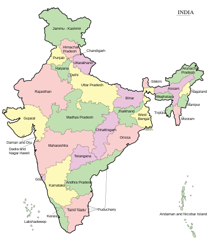
English: Map of India - states and union territories marked मराठी: भारताचा नकाशा हिन्दी : भारत का मानचित्र - राज्य और केंद्रशासित प्रदेश चिह्नित हैं বাংলা : ভারত দেশের মানচিত্র ਪੰਜਾਬੀ : ਭਾਰਤ ਦਾ ਨਕਸ਼ਾ ગુજરાતી : ભારતનો નકશો : રાજ્ય અને કેન્દ્રશાસિત પ્રદેશો ଓଡ଼ିଆ : ଭାରତ ମାନଚିତ୍ର தமிழ் : இந்தியாவின் வரைபடம் - மாநிலங்கள் மற்றும் யூனியன் பிரதேசங்கள் குறிக்கப்பட்டுள்ளன ಕನ್ನಡ : ಭಾರತದ ಭೂಪಟ മലയാളം : ഇന്ത്യയുടെ ഭൂപടം - സംസ്ഥാനങ്ങളും കേന്ദ്രഭരണപ്രദേശങ്ങളും അടയാളപ്പെടുത്തിയിരിക്കുന്നു اردو : بھارت کا نقشہ |
||
| تریخ | |||
| سروت | Transferred from ml.wikipedia to Commons. | ||
| لکھاری | Rajeshodayanchal at Malayalam وکیپیڈیا. | ||
| دوجے ورژن |
[]
|


|
This SVG file contains embedded text that can be translated into your language, using any capable SVG editor, text editor or the SVG Translate tool. For more information see: About translating SVG files. |
لائسنس –
This media file is uploaded with Malayalam loves Wikimedia event.
|
Rajeshodayanchal at Malayalam وکیپیڈیا، اس کم دے کاپیرائٹ دا مالک، اس کم نوں اس لائسنس دے مطابق چھاپدا واں:
ایس فائل نوں کریٹو کامنز Attribution 2.5 پولینڈ لائسنس دتا گیا.
کس دے ناں: Rajeshodayanchal at Malayalam وکیپیڈیا
- تہانوں کھلھ اے:
- حصہ کرنا – کاپی، ونڈنا تے کم بھیجنا
- فیر رلانا – کم نوں فٹ کرنا
- تھلے دتیاں شرطاں نال:
- کس دے ناں – تسیں لازمی ایس کم دے بناں والے بارے دسو جنج اونے آکھیا اے یا جنج لسنس چ آکھیا گیا ہے۔
- اکو جہا شئیر کرو۔ – اگر تسیں بدلدے یا ایس کم تے بناندے تے بنن والے کم نوں اینج دے لسنس نال ای ونڈو گے۔
پہلا اپلوڈ دا ریکارڈ
This file was originally uploaded at ml.wikipedia as India-map-en.svg, before it was transfered to Commons.
Upload date | User | Bytes | Dimensions | Comment
- 4/10/2011 10:29:58 AM | Rajeshodayanchal | 277070 (bytes) | 1519×1773 | വിട്ടുപോയ കേന്ദ്രഭരണപ്രദേശങ്ങൾ കൂട്ടിച്ചേർക്കുന്നു
- 4/10/2011 2:28:09 AM | Rajeshodayanchal | 254531 (bytes) | 1519×1773 | {{വിവരങ്ങൾ |വിവരണം = ഇന്ത്യയുടെ ഭൂപടം - സംസ്ഥാനങ്ങളും കേന്ദ്രഭരണപ്രദേശങ്ങളും അടയാളപ്പെടുത്തി�
فائل دی تریخ
فائل نو اس ویلے دی حالت وچ ویکھن واسطے تاریخ/ویلے تے کلک کرو۔
| تریخ تے ویلہ | نکی مورت | پاسے | ورتن والا | تیپّݨی کرو | |
|---|---|---|---|---|---|
| موجودہ | ۱۲:۵۵, ۷ جون ۲۰۱۷ | | ۱,۵۱۹ × ۱,۷۷۳ (۲۷۷ کلوبائٹ) | Rajeshodayanchal | Updated the map with a new state Telangana |
| ۱۸:۳۲, ۱۰ اپریل ۲۰۱۱ |  | ۱,۵۱۹ × ۱,۷۷۳ (۲۷۱ کلوبائٹ) | Sreejithk2000 |
فائل دی ورتوں
تھلے دتے گئے 1 صفحے اس فائل نال جُڑدے نیں
فائل ویاپک ورتوں
ایہہ دوجے وکیاں ایس فائل نوں ورتدے نیں –
- af.wikipedia.org تے ورتوں
- bcl.wikipedia.org تے ورتوں
- bh.wikipedia.org تے ورتوں
- blk.wikipedia.org تے ورتوں
- bn.wikipedia.org تے ورتوں
- ca.wikipedia.org تے ورتوں
- de.wikipedia.org تے ورتوں
- dty.wikipedia.org تے ورتوں
- dv.wikipedia.org تے ورتوں
- en.wikipedia.org تے ورتوں
- es.wikipedia.org تے ورتوں
- fo.wikipedia.org تے ورتوں
- fr.wikipedia.org تے ورتوں
- gom.wikipedia.org تے ورتوں
- gu.wikipedia.org تے ورتوں
- he.wikipedia.org تے ورتوں
- hif.wikipedia.org تے ورتوں
- hi.wikipedia.org تے ورتوں
- ilo.wikipedia.org تے ورتوں
- ja.wikipedia.org تے ورتوں
- ka.wikipedia.org تے ورتوں
- km.wikipedia.org تے ورتوں
- kn.wikipedia.org تے ورتوں
ایس فائل دا ویکھو ہور جگت ورتن .