فائل:Iles Eparses-CIA WFB Map.png

ایس وکھالے دا ناپ: ۴۶۸ × ۶۰۰ پکسلز۔ دوجے ریزولوشنز: ۱۸۷ × ۲۴۰ پکسلز | ۵۶۹ × ۷۲۹ پکسلز ۔
اصل فائل (۵۶۹ × ۷۲۹ پکسلز, فائل حجم: ۲۷ کلوبائٹ, MIME type: image/png)
خلاصہ
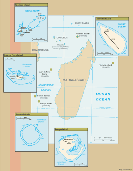
New map of Iles Eparses from 7 Sept 06 rev. of the World Factbook: https://www.cia.gov/cia/publications/factbook/geos/zz.html archive copy at the Wayback Machine
لائسنس –
This image is in the public domain because it contains materials that originally came from the United States Central Intelligence Agency's World Factbook.
|
 |
فائل دی تریخ
فائل نو اس ویلے دی حالت وچ ویکھن واسطے تاریخ/ویلے تے کلک کرو۔
| تریخ تے ویلہ | نکی مورت | پاسے | ورتن والا | تیپّݨی کرو | |
|---|---|---|---|---|---|
| موجودہ | ۲۱:۰۷, ۸ ستمبر ۲۰۰۶ | | ۵۶۹ × ۷۲۹ (۲۷ کلوبائٹ) | Hoshie | ==Summary== New map of Iles Eparses from 7 Sept 06 rev. of the World Factbook: [https://www.cia.gov/cia/publications/factbook/geos/zz.html https://www.cia.gov/cia/publications/factbook/geos/zz.html] ==Licensing== {{PD-USGov-CIA-WF}} |
فائل دی ورتوں
تھلے دتے گئے 1 صفحے اس فائل نال جُڑدے نیں
فائل ویاپک ورتوں
ایہہ دوجے وکیاں ایس فائل نوں ورتدے نیں –
- az.wikipedia.org تے ورتوں
- en.wikipedia.org تے ورتوں
- es.wikipedia.org تے ورتوں
- fa.wikipedia.org تے ورتوں
- fr.wikipedia.org تے ورتوں
- fr.wiktionary.org تے ورتوں
- gcr.wikipedia.org تے ورتوں
- hi.wikipedia.org تے ورتوں
- id.wikipedia.org تے ورتوں
- ka.wikipedia.org تے ورتوں
- ko.wikipedia.org تے ورتوں
- lv.wikipedia.org تے ورتوں
- mg.wikipedia.org تے ورتوں
- simple.wikipedia.org تے ورتوں
- sr.wikipedia.org تے ورتوں
- sv.wikipedia.org تے ورتوں
- uk.wikipedia.org تے ورتوں
- ur.wikipedia.org تے ورتوں
- zh.wikipedia.org تے ورتوں