فائل:First ETR in China.svg

Size of this PNG preview of this SVG file: ۷۰۵ × ۵۹۹ پکسلز. دوجے ریزولوشنز: ۲۸۲ × ۲۴۰ پکسلز | ۵۶۵ × ۴۸۰ پکسلز | ۹۰۴ × ۷۶۸ پکسلز | ۱,۲۰۵ × ۱,۰۲۴ پکسلز | ۲,۴۰۹ × ۲,۰۴۸ پکسلز | ۱,۰۰۰ × ۸۵۰ پکسلز ۔
اصل فائل (ایس وی جی فائل، پکسل:۱,۰۰۰ × ۸۵۰، فائل سائز: ۲۳۲ کلوبائٹ)
خلاصہ
| تفصیل |
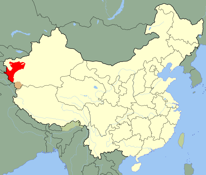
A SVG map of China with Xinjiang's Kashgar Prefecture highlighted in red; the modern-day district in which the w:en:First East Turkestan Republic was located. Legend: |
||
| تریخ | (UTC) | ||
| سروت | |||
| لکھاری |
|
||
| SVG genesis |
|
.svg)
| This is a retouched picture, which means that it has been digitally altered from its original version. Modifications: Unhighlighted Xinjiang as a whole, removed sub-provincial markers. The original can be viewed here: China Xinjiang Kashgar.svg:
|
لائسنس –
میں، اس کم دے کاپیرائٹ دا مالک، اس کم نوں اس لائسنس دے مطابق چھاپدا واں:
| میں، اس کم دے کاپیرائٹ دا مالک، اس کم نوں لوکاں واسطے دیندا واں۔ اے سارے جگ واسطے لاگو اے۔ کج ملکاں چ قانونی طور تے اے ممکن نئیں اے؛ اگر انج ای اے ے: میں ہر کسے نوں اس کم نوں کسے وی مقصد واسطے ورتن دا بغیر کسے شرط دے حق دیندا واں، اگر اوہ قانون دے خلاف نا ہوۓ۔ |
پہلا اپلوڈ دا ریکارڈ
This image is a derivative work of the following images:
- File:China_Xinjiang_Kashgar.svg licensed with PD-self
- 2010-02-12T14:52:39Z Joowwww 1000x850 (237684 Bytes) {{Information |Description=An SVG map of China with Xinjiang highlighted in orange and Kashgar Prefecture highlighted in red Legend:[[:File:China map legend.png]] |Source=self-made; based on CIA public domain maps: *http://w
Uploaded with derivativeFX
فائل دی تریخ
فائل نو اس ویلے دی حالت وچ ویکھن واسطے تاریخ/ویلے تے کلک کرو۔
| تریخ تے ویلہ | نکی مورت | پاسے | ورتن والا | تیپّݨی کرو | |
|---|---|---|---|---|---|
| موجودہ | ۰۲:۱۰, ۲۵ مئی ۲۰۲۰ | | ۱,۰۰۰ × ۸۵۰ (۲۳۲ کلوبائٹ) | Roy17 | Reverted to version as of 23:09, 18 August 2010 (UTC) |
| ۰۷:۳۹, ۲۴ مئی ۲۰۲۰ |  | ۱,۰۰۰ × ۸۱۰ (۲۴۹ کلوبائٹ) | Anchuhu | Reverted to version as of 12:39, 19 January 2019 (UTC) roc borders isn’t like China now | |
| ۰۶:۴۳, ۱۲ مارچ ۲۰۲۰ |  | ۱,۰۰۰ × ۸۵۰ (۲۳۲ کلوبائٹ) | Jonteemil | Reverted to version as of 23:09, 18 August 2010 (UTC) | |
| ۱۷:۳۹, ۱۹ جنوری ۲۰۱۹ |  | ۱,۰۰۰ × ۸۱۰ (۲۴۹ کلوبائٹ) | 复旦大学张超 | edit | |
| ۰۴:۰۹, ۱۹ اگست ۲۰۱۰ |  | ۱,۰۰۰ × ۸۵۰ (۲۳۲ کلوبائٹ) | Splittist | {{Information |Description=A SVG map of China with Xinjiang's Kashgar Prefecture highlighted in red; the modern-day district in which the w:en:First East Turkestan Republic was located. Legend:<br />File:China map legend.png |Source=*[[:File:China |
فائل دی ورتوں
تھلے دتے گئے 1 صفحے اس فائل نال جُڑدے نیں
فائل ویاپک ورتوں
ایہہ دوجے وکیاں ایس فائل نوں ورتدے نیں –
- ar.wikipedia.org تے ورتوں
- azb.wikipedia.org تے ورتوں
- az.wikipedia.org تے ورتوں
- bn.wikipedia.org تے ورتوں
- de.wikipedia.org تے ورتوں
- en.wikipedia.org تے ورتوں
- es.wikipedia.org تے ورتوں
- eu.wikipedia.org تے ورتوں
- fa.wikipedia.org تے ورتوں
- fr.wikipedia.org تے ورتوں
- id.wikipedia.org تے ورتوں
- incubator.wikimedia.org تے ورتوں
- it.wikipedia.org تے ورتوں
- ja.wikipedia.org تے ورتوں
- ko.wikipedia.org تے ورتوں
- lv.wikipedia.org تے ورتوں
- nl.wikipedia.org تے ورتوں
- nn.wikipedia.org تے ورتوں
- pl.wikipedia.org تے ورتوں
- pt.wikipedia.org تے ورتوں
- ru.wikipedia.org تے ورتوں
- sr.wikipedia.org تے ورتوں
ایس فائل دا ویکھو ہور جگت ورتن .