فائل:European settlements in India 1501-1739.png

ایس وکھالے دا ناپ: ۸۰۰ × ۴۹۱ پکسلز۔ دوجے ریزولوشنز: ۳۲۰ × ۱۹۶ پکسلز | ۶۴۰ × ۳۹۳ پکسلز | ۱,۱۴۰ × ۷۰۰ پکسلز ۔
اصل فائل (۱,۱۴۰ × ۷۰۰ پکسلز, فائل حجم: ۱۶۸ کلوبائٹ, MIME type: image/png)
خلاصہ
| تفصیل |
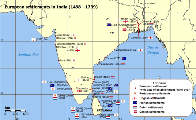
English: Map of India with Sri Lanka, illustrating locations of European settlements in the subcontinent between 1501 and 1739.
Norsk nynorsk: Kart over Sør-Asia med europeiske koloniar/busetjingar mellom 1501 og 1739.
Dansk: Kort af Indien inkl. Sri Lanka med europæiske kolonier mellem 1501 og 1739. |
| تریخ | uploaded in 2006 |
| سروت |
Self-published work by Luis wiki Map reference: [1] at w:University of Pennsylvania, with reference varification from: [2] (URL accessed: 23-Mar-2006) |
| لکھاری | Luis wiki |
| دوجے ورژن |
|

![[1]](http://www.history.upenn.edu/coursepages/hist086/material/schmidt26a.jpg)

|
This map of asia image could be re-created using vector graphics as an SVG file. This has several advantages; see Commons:Media for cleanup for more information. If an SVG form of this image is available, please upload it and afterwards replace this template with
{{vector version available|new image name}}.
It is recommended to name the SVG file “European settlements in India 1501-1739.svg”—then the template Vector version available (or Vva) does not need the new image name parameter. |
لائسنس –
میں، اس کم دے کاپیرائٹ دا مالک، اس کم نوں اس لائسنس دے مطابق چھاپدا واں:
ایس فائل نوں کریٹو کامنز Attribution 2.5 جنرک لائسنس دتا گیا.
- تہانوں کھلھ اے:
- حصہ کرنا – کاپی، ونڈنا تے کم بھیجنا
- فیر رلانا – کم نوں فٹ کرنا
- تھلے دتیاں شرطاں نال:
- کس دے ناں – تسیں لازمی ایس کم دے بناں والے بارے دسو جنج اونے آکھیا اے یا جنج لسنس چ آکھیا گیا ہے۔
- اکو جہا شئیر کرو۔ – اگر تسیں بدلدے یا ایس کم تے بناندے تے بنن والے کم نوں اینج دے لسنس نال ای ونڈو گے۔
فائل دی تریخ
فائل نو اس ویلے دی حالت وچ ویکھن واسطے تاریخ/ویلے تے کلک کرو۔
| تریخ تے ویلہ | نکی مورت | پاسے | ورتن والا | تیپّݨی کرو | |
|---|---|---|---|---|---|
| موجودہ | ۱۹:۴۷, ۱۲ مارچ ۲۰۱۱ | | ۱,۱۴۰ × ۷۰۰ (۱۶۸ کلوبائٹ) | Luis wiki | Bombay, Portuguese from 1534, later on British |
| ۰۳:۳۰, ۶ فروری ۲۰۱۱ |  | ۱,۱۴۰ × ۷۰۰ (۱۹۸ کلوبائٹ) | Henry Bottomley~commonswiki | Title date (see Calicut), Goa date, Flags of the time of Portugal, France and England | |
| ۰۱:۴۹, ۳ مارچ ۲۰۱۰ |  | ۱,۱۴۰ × ۷۰۰ (۱۵۸ کلوبائٹ) | Brianski | Fix spelling of "Portuguese" | |
| ۰۱:۳۴, ۲۳ فروری ۲۰۰۷ |  | ۱,۱۴۰ × ۷۰۰ (۲۱۴ کلوبائٹ) | Wereon | "CE" unnecessary | |
| ۱۷:۳۲, ۲۳ مارچ ۲۰۰۶ |  | ۱,۱۴۰ × ۷۰۰ (۲۳۲ کلوبائٹ) | Miljoshi | Map of India with Sri Lanka, illustrating locations of European settlements in the subcontinent between 1501 and 1739 CE. Category:India |
فائل دی ورتوں
تھلے دتے گئے 1 صفحے اس فائل نال جُڑدے نیں
فائل ویاپک ورتوں
ایہہ دوجے وکیاں ایس فائل نوں ورتدے نیں –
- af.wikipedia.org تے ورتوں
- ar.wikipedia.org تے ورتوں
- ast.wikipedia.org تے ورتوں
- as.wikipedia.org تے ورتوں
- azb.wikipedia.org تے ورتوں
- az.wikipedia.org تے ورتوں
- bn.wikipedia.org تے ورتوں
- br.wikipedia.org تے ورتوں
- ca.wikipedia.org تے ورتوں
- cs.wikipedia.org تے ورتوں
- da.wikipedia.org تے ورتوں
- da.wikibooks.org تے ورتوں
- de.wikipedia.org تے ورتوں
- el.wikipedia.org تے ورتوں
- en.wikipedia.org تے ورتوں
- eo.wikipedia.org تے ورتوں
- es.wikipedia.org تے ورتوں
ایس فائل دا ویکھو ہور جگت ورتن .