فائل:Europe 1815 map en.png

ایس وکھالے دا ناپ: ۸۰۰ × ۵۲۶ پکسلز۔ دوجے ریزولوشنز: ۳۲۰ × ۲۱۱ پکسلز | ۶۴۰ × ۴۲۱ پکسلز | ۱,۰۲۴ × ۶۷۴ پکسلز | ۱,۲۸۰ × ۸۴۲ پکسلز | ۲,۲۸۴ × ۱,۵۰۳ پکسلز ۔
اصل فائل (۲,۲۸۴ × ۱,۵۰۳ پکسلز, فائل حجم: ۱.۰۸ میگابائٹ, MIME type: image/png)
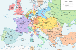
Map of Europe 1815, After the Congress of Vienna.
خلاصہ
| تفصیل |
English: Europe 1815. Political situation after the Congress of Vienna in June 1815. Please don't alter the map when you think there is something not written or depicted correctly. Leave a message at the talk page of the file. After a verificiation and a possible discussion, I will upload a new map version with all new changes. This prevents an unnecessary waste of disk space and ensures a good result, aesthetically and content-wise. - The author. Español: Mapa de Europa en 1815. Situación política tras el Congreso de Viena en junio de 1815.
Deutsch: Europa 1815. Politische Lage nach dem Wiener Kongress im Juni 1815.
Bitte die Karte bei Änderungs- und Korrekturwünschen nicht selbst verändern, sondern eine Anmerkung im Diskussionsbereich der Bilddatei hinterlassen. Nach einer Prüfung und ggfs. Diskussion werden evtl. Änderungen von mir zusammengefasst eingearbeitet. Das vermeidet unnötige Speicherplatz-Verschwendung und gewährleistet ein ästhetisch ansprechendes und inhaltlich korrektes Ergebnis. - Der Urheber. Français : Carte de l'Europe en 1815. Situation politique après le Congrès de Vienne en juin 1815.
Italiano: Mappa dell'Europa nel 1815. Situazione politica dopo il Congresso di Vienna nel giugno 1815.
Русский: Карта Европы 1815 года. Политическая ситуация после Венского конгресса в июне 1815 года.
Português: Mapa da Europa em 1815. Situação política após o Congresso de Viena em junho de 1815. |
| تریخ | |
| سروت |
آپݨا کم. Source of Information: Historical atlases – Map "1815 - L'Europe après le Congrès de Vienne" (Author unknown)(Link) – Ramsay Muir, George Philip (ed.): Philip's New School Atlas of Universal History, George Philip & Son, Ltd., London 1928 – Dr. Walter Leisering (ed.): Putzger Historischer Weltatlas, Cornelsen Verlag, Berlin 1992, ISBN 3-464-00176-8 – Bayerischer Schulbuch-Verlag (ed.): Großer Historischer Weltatlas, Dritter Teil, Neuzeit, Bayerischer Schulbuch-Verlag, München 1981, ISBN 3-7627-6021-7. – Prof. Dr. Hans-Erich Stier, Prof. Dr. Ernst Kirsten a. o. (ed.): Großer Atlas zur Weltgeschichte, Orbis Verlag, München 1990, ISBN 3-7627-6021-7 Other publications – Reinhard Stauber: Der Wiener Kongress, Böhlau Verlag, Wien/Köln/Weimar 2014, ISBN 978-3-8252-4095-0 – Thierry Lentz: 1815. Der Wiener Kongress und die Neugründung Europas, Siedler Verlag, München 2014, ISBN 978-3-8275-0027-4 |
| لکھاری | Alexander Altenhof |
| دوجے ورژن |
|

Recompressed without quality loss with OptiPNG (1.36 MB > 1.06 MB)
لائسنس –
میں، اس کم دے کاپیرائٹ دا مالک، اس کم نوں اس لائسنس دے مطابق چھاپدا واں:
This file is licensed under the Creative Commons Attribution-Share Alike 4.0 International license.
- تہانوں کھلھ اے:
- حصہ کرنا – کاپی، ونڈنا تے کم بھیجنا
- فیر رلانا – کم نوں فٹ کرنا
- تھلے دتیاں شرطاں نال:
- کس دے ناں – تسیں لازمی ایس کم دے بناں والے بارے دسو جنج اونے آکھیا اے یا جنج لسنس چ آکھیا گیا ہے۔
- اکو جہا شئیر کرو۔ – اگر تسیں بدلدے یا ایس کم تے بناندے تے بنن والے کم نوں اینج دے لسنس نال ای ونڈو گے۔

|
This map image could be re-created using vector graphics as an SVG file. This has several advantages; see Commons:Media for cleanup for more information. If an SVG form of this image is available, please upload it and afterwards replace this template with
{{vector version available|new image name}}.
It is recommended to name the SVG file “Europe 1815 map en.svg”—then the template Vector version available (or Vva) does not need the new image name parameter. |
فائل دی تریخ
فائل نو اس ویلے دی حالت وچ ویکھن واسطے تاریخ/ویلے تے کلک کرو۔
| تریخ تے ویلہ | نکی مورت | پاسے | ورتن والا | تیپّݨی کرو | |
|---|---|---|---|---|---|
| موجودہ | ۰۴:۳۶, ۱۵ اپریل ۲۰۱۷ | | ۲,۲۸۴ × ۱,۵۰۳ (۱.۰۸ میگابائٹ) | KaterBegemot | Corrected "K. of Bavaria" caption / minor changes |
| ۰۲:۵۰, ۱۲ ستمبر ۲۰۱۶ |  | ۲,۲۸۴ × ۱,۵۰۳ (۱.۳۶ میگابائٹ) | KaterBegemot | Kingdom of Spain same green color like in the other maps | |
| ۰۲:۳۸, ۱۲ ستمبر ۲۰۱۶ |  | ۲,۲۸۴ × ۱,۵۰۳ (۱.۰۶ میگابائٹ) | KaterBegemot | Deleted black border at Austrian part of the German Confederation border, P. of Monaco smaller, corrected border at Tarnopol area, changed spacing of K. of Netherlands text | |
| ۱۶:۲۳, ۲۰ جولائی ۲۰۱۶ |  | ۲,۲۸۴ × ۱,۵۰۳ (۱.۰۷ میگابائٹ) | KaterBegemot | {{Information |Description ={{en|1=Europe 1815. Political situation after the Congress of Vienna in June 1815.<br> ''Please don't alter the map, when you think there something not written or depicted correclty. Leave a mes... |
فائل دی ورتوں
تھلے دتے گئے 3 صفحے اس فائل نال جُڑدے نیں
فائل ویاپک ورتوں
ایہہ دوجے وکیاں ایس فائل نوں ورتدے نیں –
- avk.wikipedia.org تے ورتوں
- azb.wikipedia.org تے ورتوں
- bg.wikipedia.org تے ورتوں
- bs.wikipedia.org تے ورتوں
- cs.wikipedia.org تے ورتوں
- da.wikipedia.org تے ورتوں
- el.wikipedia.org تے ورتوں
- eml.wikipedia.org تے ورتوں
- en.wikipedia.org تے ورتوں
- Europe
- History of Europe
- 1810s
- History of Austria
- Congress of Vienna
- Napoleonic Wars
- History of the Czech lands
- Klemens von Metternich
- Karl August von Hardenberg
- Concert of Europe
- Former countries in Europe after 1815
- Balance of power (international relations)
- Monarchies in Europe
- Federal Convention (German Confederation)
- Portal:Czech Republic
- European balance of power
- 19th century
- International relations (1814–1919)
- Timeline of Karl Marx
- Timeline of the 19th century
- User:Falcaorib
- Secret Treaty of Vienna
- Talk:Europe/Archive 11
- User:SocratesGR
- en.wikibooks.org تے ورتوں
- en.wikiquote.org تے ورتوں
- eo.wikipedia.org تے ورتوں
- eo.wikiquote.org تے ورتوں
- es.wikipedia.org تے ورتوں
- et.wikipedia.org تے ورتوں
- eu.wikipedia.org تے ورتوں
- fa.wikipedia.org تے ورتوں
- fi.wikipedia.org تے ورتوں
- fr.wikipedia.org تے ورتوں
ایس فائل دا ویکھو ہور جگت ورتن .