فائل:Europe-Isle of Man.svg

Size of this PNG preview of this SVG file: ۷۱۳ × ۶۰۰ پکسلز. دوجے ریزولوشنز: ۲۸۵ × ۲۴۰ پکسلز | ۵۷۱ × ۴۸۰ پکسلز | ۹۱۳ × ۷۶۸ پکسلز | ۱,۲۱۸ × ۱,۰۲۴ پکسلز | ۲,۴۳۵ × ۲,۰۴۸ پکسلز | ۲,۰۴۵ × ۱,۷۲۰ پکسلز ۔
اصل فائل (ایس وی جی فائل، پکسل:۲,۰۴۵ × ۱,۷۲۰، فائل سائز: ۲.۲۴ میگابائٹ)
خلاصہ
| تفصیل |
English:
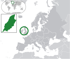
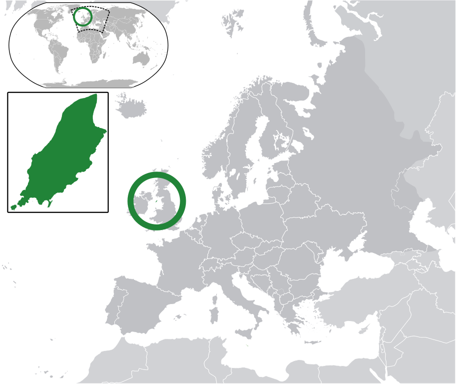
Map in English of the Isle of Man, with bounds of sheadings, towns, villages, districts and parishes. (Green) Isle of Man.
(Gray) Europe.
(Light-gray) The surrounding region.
The Full Map of the Isle of Man |
||
| تریخ | |||
| سروت | Own work based on: IsleOfMan SheadingsAndParishes-en.svg | ||
| لکھاری | Chipmunkdavis | ||
| اجازت (فائل نوں دوبارہ ورتنا) |
ایس فائل نوں کریٹو کامنز Attribution 2.5 پولینڈ لائسنس دتا گیا.
|
||
| SVG genesis |
|
پہلا اپلوڈ دا ریکارڈ
This image is a derivative work of the following images:
- licensed with Cc-by-sa-3.0
- 2011-02-21T07:49:57Z Chipmunkdavis 2045x1720 (2394864 Bytes)
- IsleOfMan SheadingsAndParishes-en.svg licensed with Cc-by-sa-3.0,2.5,2.0,1.0, GFDL
- 2008-01-17T12:48:28Z Sémhur 1200x1100 (227618 Bytes) Update
- 2007-05-29T20:36:04Z Sémhur 0x0 (364350 Bytes) {{Information |Description=Map in English of the [[:en:Isle of Man|Isle of Man]], with bounds of sheadings, towns, villages, districts and parishes. |Source=Own work. Based on maps [[:Image:Isle of Man map-fr.svg]], [[:Image:
Uploaded with derivativeFX
فائل دی تریخ
فائل نو اس ویلے دی حالت وچ ویکھن واسطے تاریخ/ویلے تے کلک کرو۔
| تریخ تے ویلہ | نکی مورت | پاسے | ورتن والا | تیپّݨی کرو | |
|---|---|---|---|---|---|
| موجودہ | ۱۱:۱۰, ۲ مارچ ۲۰۱۱ | | ۲,۰۴۵ × ۱,۷۲۰ (۲.۲۴ میگابائٹ) | Chipmunkdavis | Redid inset |
| ۱۱:۰۳, ۲ مارچ ۲۰۱۱ |  | ۲,۰۴۵ × ۱,۷۲۰ (۲.۲۲ میگابائٹ) | Chipmunkdavis | Without inset | |
| ۱۱:۰۱, ۲ مارچ ۲۰۱۱ |  | ۲,۰۴۵ × ۱,۷۲۰ (۲.۲۲ میگابائٹ) | Chipmunkdavis | One more try | |
| ۱۴:۰۳, ۲۱ فروری ۲۰۱۱ |  | ۲,۰۴۵ × ۱,۷۲۰ (۲.۲۲ میگابائٹ) | Chipmunkdavis | Grouped inset | |
| ۱۴:۰۰, ۲۱ فروری ۲۰۱۱ |  | ۲,۰۴۵ × ۱,۷۲۰ (۲.۲۲ میگابائٹ) | Chipmunkdavis | File not appearing properly, reuploading | |
| ۱۳:۰۶, ۲۱ فروری ۲۰۱۱ |  | ۲,۰۴۵ × ۱,۷۲۰ (۲.۲۲ میگابائٹ) | Chipmunkdavis | {{Information |Description={{en|1={{Europe-SVG-en|Northern Cyprus}}}} {{en|1=The Full Map of Jersey}} Map in english of the Isle of Man, with bounds of sheadings, towns, villages, districts and parishes. |Source=*[[:File:Europe-Jersey. |
فائل دی ورتوں
تھلے دتے گئے 1 صفحے اس فائل نال جُڑدے نیں
فائل ویاپک ورتوں
ایہہ دوجے وکیاں ایس فائل نوں ورتدے نیں –
- ace.wikipedia.org تے ورتوں
- an.wikipedia.org تے ورتوں
- ar.wikipedia.org تے ورتوں
- arz.wikipedia.org تے ورتوں
- ast.wikipedia.org تے ورتوں
- az.wikipedia.org تے ورتوں
- ba.wikipedia.org تے ورتوں
- bg.wikipedia.org تے ورتوں
- bh.wikipedia.org تے ورتوں
- bn.wikipedia.org تے ورتوں
- ca.wikipedia.org تے ورتوں
- cdo.wikipedia.org تے ورتوں
- cs.wikipedia.org تے ورتوں
- diq.wikipedia.org تے ورتوں
- en.wikipedia.org تے ورتوں
- eo.wikipedia.org تے ورتوں
- es.wikipedia.org تے ورتوں
- ext.wikipedia.org تے ورتوں
- fi.wiktionary.org تے ورتوں
- fr.wikipedia.org تے ورتوں
- ga.wikipedia.org تے ورتوں
- gl.wikipedia.org تے ورتوں
- hak.wikipedia.org تے ورتوں
- ha.wikipedia.org تے ورتوں
- he.wikipedia.org تے ورتوں
- ia.wikipedia.org تے ورتوں
- incubator.wikimedia.org تے ورتوں
- it.wikipedia.org تے ورتوں
- ja.wikipedia.org تے ورتوں
- kab.wikipedia.org تے ورتوں
- kk.wikipedia.org تے ورتوں
- km.wikipedia.org تے ورتوں
- la.wikipedia.org تے ورتوں
- lb.wikipedia.org تے ورتوں
- lij.wikipedia.org تے ورتوں
- lv.wikipedia.org تے ورتوں
- mk.wikipedia.org تے ورتوں
ایس فائل دا ویکھو ہور جگت ورتن .