فائل:Europe, 1700—1714.png

ایس وکھالے دا ناپ: ۸۰۰ × ۵۴۶ پکسلز۔ دوجے ریزولوشنز: ۳۲۰ × ۲۱۹ پکسلز | ۶۴۰ × ۴۳۷ پکسلز | ۱,۰۲۴ × ۶۹۹ پکسلز | ۱,۲۸۰ × ۸۷۴ پکسلز | ۱,۵۹۰ × ۱,۰۸۶ پکسلز ۔
اصل فائل (۱,۵۹۰ × ۱,۰۸۶ پکسلز, فائل حجم: ۱.۰۷ میگابائٹ, MIME type: image/png)

|
This map of europe image could be re-created using vector graphics as an SVG file. This has several advantages; see Commons:Media for cleanup for more information. If an SVG form of this image is available, please upload it and afterwards replace this template with
{{vector version available|new image name}}.
It is recommended to name the SVG file “Europe, 1700—1714.svg”—then the template Vector version available (or Vva) does not need the new image name parameter. |
خلاصہ
| تفصیل |
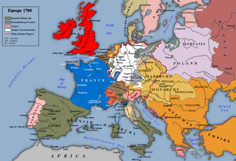
English: Map of Europe 1700. |
| تریخ | |
| سروت |
Own work based on: an image in Trevelyan, George Macaulay (۱۹۳۰) England Under Queen Anne، I، لندن: Longmans, Green and Co.
|
| لکھاری | Rebel Redcoat |
| دوجے ورژن |
.png)
لائسنس –
| میں، اس کم دے کاپیرائٹ دا مالک، اس کم نوں لوکاں واسطے دیندا واں۔ اے سارے جگ واسطے لاگو اے۔ کج ملکاں چ قانونی طور تے اے ممکن نئیں اے؛ اگر انج ای اے ے: میں ہر کسے نوں اس کم نوں کسے وی مقصد واسطے ورتن دا بغیر کسے شرط دے حق دیندا واں، اگر اوہ قانون دے خلاف نا ہوۓ۔ |
فائل دی تریخ
فائل نو اس ویلے دی حالت وچ ویکھن واسطے تاریخ/ویلے تے کلک کرو۔
| تریخ تے ویلہ | نکی مورت | پاسے | ورتن والا | تیپّݨی کرو | |
|---|---|---|---|---|---|
| موجودہ | ۲۳:۰۷, ۷ نومبر ۲۰۲۲ | | ۱,۵۹۰ × ۱,۰۸۶ (۱.۰۷ میگابائٹ) | Gyalu22 | Reverted to version as of 18:08, 26 November 2018 (UTC) |
| ۱۵:۰۶, ۱۹ جنوری ۲۰۱۹ |  | ۱,۵۹۰ × ۱,۰۸۶ (۱.۰۸ میگابائٹ) | Julieta39 | Some details according with Stier, H.E. (dir.) ''Grosser Atlas zur Weltgeschichte'', Westermann 1985, {{ISBN|3-14-100919-8}}; ''Putzger historischer Weltatlas'', Cornelsen 1990, {{ISBN|3-464-00176-8}}; Sellier, André & Jean (dir.) « Atlas des Peuples », La Découverte publ.: ''Europe occidentale'', 1995, {{ISBN|2-7071-2505-9}}, ''Europe centrale'', 1992, {{ISBN|2-7071-2032-4}}, ''Orient'', 1993, {{ISBN|2-7071-2222-X}}; ''Atlas istorico-geografic'', Bucharest, Academic publ. {{ISBN|973-27-0500... | |
| ۲۳:۰۸, ۲۶ نومبر ۲۰۱۸ |  | ۱,۵۹۰ × ۱,۰۸۶ (۱.۰۷ میگابائٹ) | Goran tek-en | Changed name on rivers, Southern Bug and Dniester as requested by user:Gikü | |
| ۰۰:۱۸, ۸ جنوری ۲۰۱۴ |  | ۱,۵۹۰ × ۱,۰۸۶ (۱,۰۰۴ کلوبائٹ) | Rebel Redcoat~commonswiki | Some minor improvements/accuracy | |
| ۱۷:۲۲, ۵ مئی ۲۰۱۲ |  | ۱,۵۹۰ × ۱,۰۸۶ (۱.۰۷ میگابائٹ) | Rebel Redcoat~commonswiki | Better version | |
| ۱۷:۳۹, ۲۲ ستمبر ۲۰۱۰ |  | ۱,۵۹۴ × ۱,۰۹۰ (۲۴۵ کلوبائٹ) | Altes | there was not S.-Petersburg in 1700 | |
| ۱۹:۵۴, ۲۱ جنوری ۲۰۱۰ |  | ۱,۵۹۴ × ۱,۰۹۰ (۲۲۴ کلوبائٹ) | Rebel Redcoat~commonswiki | Improvements | |
| ۱۸:۵۸, ۲۷ مئی ۲۰۰۹ |  | ۱,۵۹۴ × ۱,۰۹۰ (۲۱۰ کلوبائٹ) | Rebel Redcoat~commonswiki | Decreased Colour Depth | |
| ۱۸:۵۶, ۲۷ مئی ۲۰۰۹ |  | ۱,۵۹۴ × ۱,۰۹۰ (۶۱۹ کلوبائٹ) | Rebel Redcoat~commonswiki | Minor Changes | |
| ۲۲:۳۵, ۸ مئی ۲۰۰۹ |  | ۱,۵۹۴ × ۱,۰۹۰ (۲۱۰ کلوبائٹ) | Rebel Redcoat~commonswiki | Minor Changes |
فائل دی ورتوں
تھلے دتے گئے 1 صفحے اس فائل نال جُڑدے نیں
فائل ویاپک ورتوں
ایہہ دوجے وکیاں ایس فائل نوں ورتدے نیں –
- arz.wikipedia.org تے ورتوں
- azb.wikipedia.org تے ورتوں
- bo.wikipedia.org تے ورتوں
- ca.wikipedia.org تے ورتوں
- cs.wikipedia.org تے ورتوں
- cv.wikipedia.org تے ورتوں
- da.wikipedia.org تے ورتوں
- el.wikipedia.org تے ورتوں
- en.wikipedia.org تے ورتوں
- en.wikibooks.org تے ورتوں
- eo.wikipedia.org تے ورتوں
- es.wikipedia.org تے ورتوں
- et.wikipedia.org تے ورتوں
- fr.wikipedia.org تے ورتوں
- fr.wikiversity.org تے ورتوں
- hi.wikibooks.org تے ورتوں
- hr.wikipedia.org تے ورتوں
- hu.wikipedia.org تے ورتوں
- hy.wikipedia.org تے ورتوں
- ia.wikipedia.org تے ورتوں
- it.wikipedia.org تے ورتوں
- ja.wikipedia.org تے ورتوں
- jv.wikipedia.org تے ورتوں
- mk.wikipedia.org تے ورتوں
- ml.wikipedia.org تے ورتوں
- nl.wikipedia.org تے ورتوں
- nn.wikipedia.org تے ورتوں
- no.wikipedia.org تے ورتوں
- pt.wikipedia.org تے ورتوں
- ro.wikipedia.org تے ورتوں
ایس فائل دا ویکھو ہور جگت ورتن .