فائل:East of England counties 2019 map.jpg
ایس وکھالے دا ناپ: ۵۷۳ × ۵۹۹ پکسلز۔ دوجے ریزولوشنز: ۲۲۹ × ۲۴۰ پکسلز | ۴۵۹ × ۴۸۰ پکسلز | ۷۳۴ × ۷۶۸ پکسلز | ۹۷۹ × ۱,۰۲۴ پکسلز | ۱,۹۵۸ × ۲,۰۴۸ پکسلز | ۵,۰۴۲ × ۵,۲۷۵ پکسلز ۔
اصل فائل (۵,۰۴۲ × ۵,۲۷۵ پکسلز, فائل حجم: ۸۷۳ کلوبائٹ, MIME type: image/jpeg)
خلاصہ
| تفصیل |
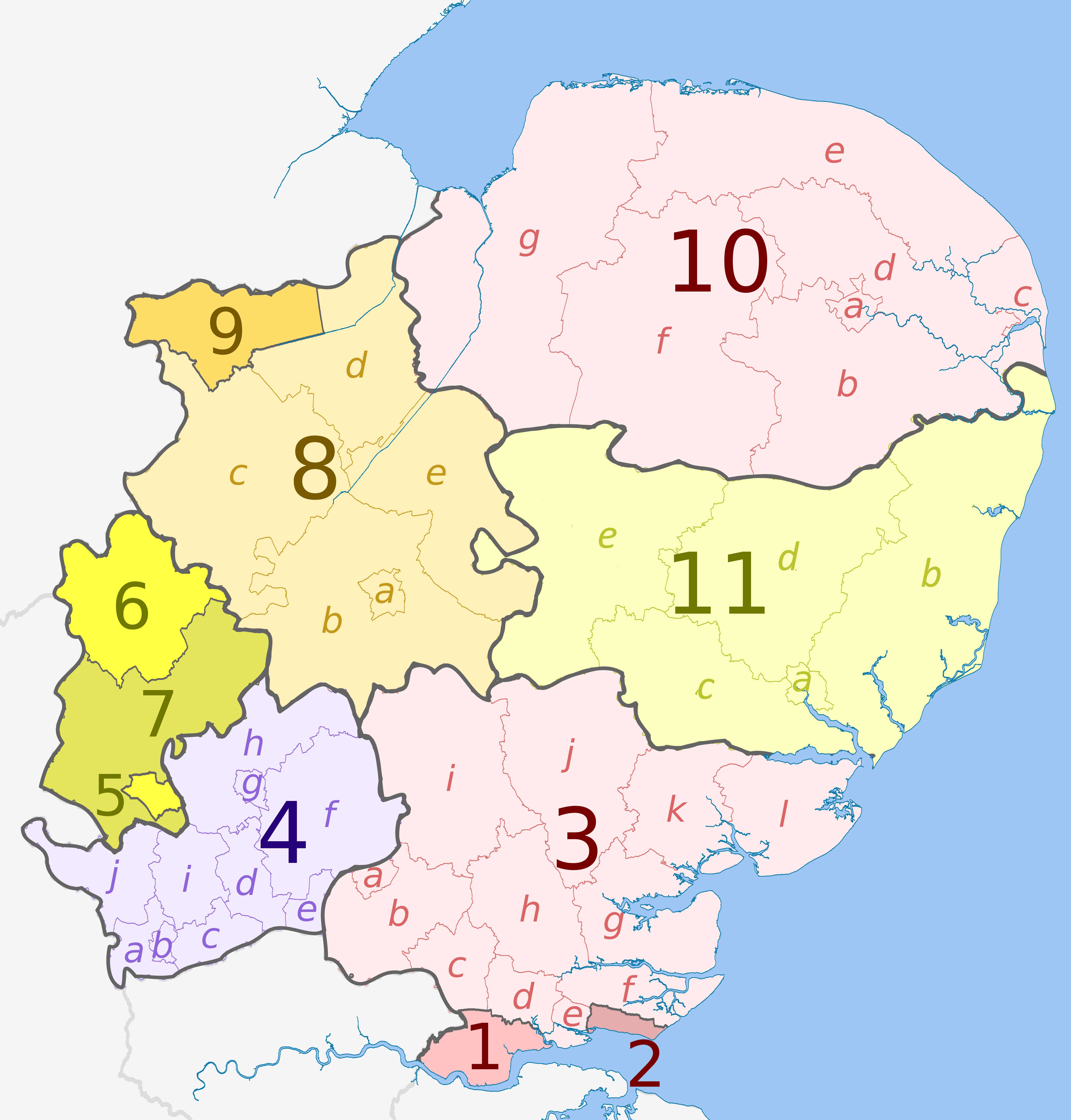
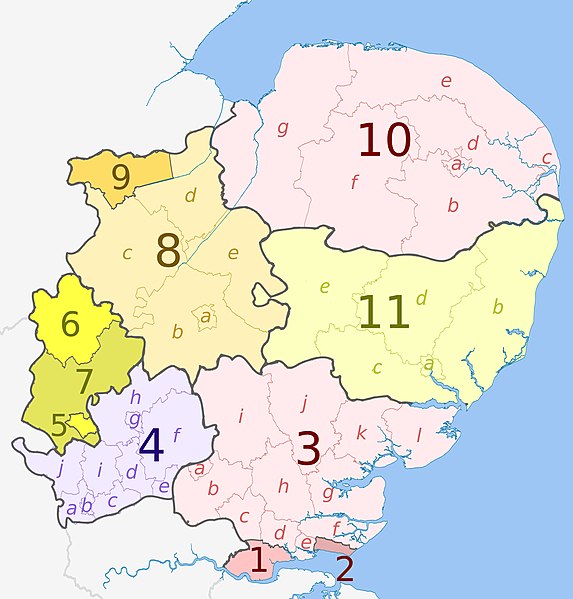
English: Map of the East of England region, showing its counties and administrative districts. The county colours are the same as those in File:English metropolitan and non-metropolitan counties 2009.svg.
Equirectangular map projection on WGS 84 datum, with N/S stretched 160% Geographic limits:
|
| تریخ | (UTC) |
| سروت |
This file was derived from: |
| لکھاری |
|


لائسنس –
ایس فائل نوں کریٹو کامنز Attribution 2.5 پولینڈ لائسنس دتا گیا.
کس دے ناں: The Equalizer, Dr Greg and Nilfanion. Contains Ordnance Survey data © Crown copyright and database right 2010
- تہانوں کھلھ اے:
- حصہ کرنا – کاپی، ونڈنا تے کم بھیجنا
- فیر رلانا – کم نوں فٹ کرنا
- تھلے دتیاں شرطاں نال:
- کس دے ناں – تسیں لازمی ایس کم دے بناں والے بارے دسو جنج اونے آکھیا اے یا جنج لسنس چ آکھیا گیا ہے۔
- اکو جہا شئیر کرو۔ – اگر تسیں بدلدے یا ایس کم تے بناندے تے بنن والے کم نوں اینج دے لسنس نال ای ونڈو گے۔
پہلا اپلوڈ دا ریکارڈ
This image is a derivative work of the following images:
- File:East_Midlands_districts_2011_map.svg licensed with Cc-by-sa-3.0, GFDL
- 2011-05-01T18:55:02Z Nilfanion 1099x1305 (1687648 Bytes) == Summary == {{Information |Description=Map of the [[w:East Midlands|East Midlands]] region showing the administrative districts. Equirectangular map projection on WGS 84 datum, with N/S stretched 165% Geographic limits: *
- File:English_ceremonial_counties_2010.svg licensed with Cc-by-sa-3.0, GFDL
- 2010-11-23T16:39:55Z Nilfanion 1108x1345 (308868 Bytes) thicker lines
- 2010-11-23T16:20:19Z Nilfanion 1108x1345 (301520 Bytes) tweaks
- 2010-10-26T20:34:20Z Nilfanion 817x990 (1391832 Bytes) {{Information |Description=Map showing the [[w:ceremonial counties of England]] including the City of London, in 2010. Equirectangular map projection on WGS 84 datum, with N/S stretched 170% Geographic limits: *West: 6.75W
- File:East of England counties 2009 map.svg licensed with Cc-by-sa-4.0, GFDL
- 2019-04-06T21:30:00Z The Equalizer Updated with district merges in Suffolk
Uploaded with derivativeFX
فائل دی تریخ
فائل نو اس ویلے دی حالت وچ ویکھن واسطے تاریخ/ویلے تے کلک کرو۔
| تریخ تے ویلہ | نکی مورت | پاسے | ورتن والا | تیپّݨی کرو | |
|---|---|---|---|---|---|
| موجودہ | ۰۱:۵۰, ۷ اپریل ۲۰۱۹ | | ۵,۰۴۲ × ۵,۲۷۵ (۸۷۳ کلوبائٹ) | The Equalizer | User created page with UploadWizard |
فائل دی ورتوں
تھلے دتے گئے 1 صفحے اس فائل نال جُڑدے نیں
فائل ویاپک ورتوں
ایہہ دوجے وکیاں ایس فائل نوں ورتدے نیں –
- de.wikipedia.org تے ورتوں
- en.wikipedia.org تے ورتوں
- hr.wikipedia.org تے ورتوں
- pl.wikipedia.org تے ورتوں
- th.wikipedia.org تے ورتوں
- ur.wikipedia.org تے ورتوں