اصل فائل (ایس وی جی فائل، پکسل:۱,۰۹۹ × ۱,۳۰۵، فائل سائز: ۱.۶۶ میگابائٹ)
ایہ فائل Wikimedia Commons توں اے تے دوجیاں ویونتاں تے وی ورتی جاسکدی اے۔
گل بات اس دے فائل گل بات صفحہ تے تھلے دتی گئی۔
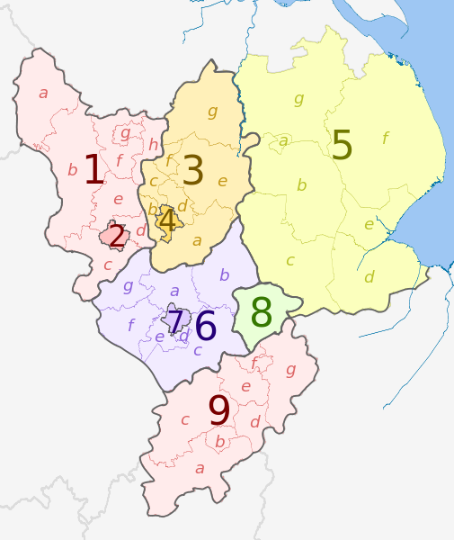
Map
Ceremonial county
Shire county
Districts
Derbyshire 1. Derbyshire
a ) High Peak , b ) Derbyshire Dales , c ) South Derbyshire , d ) Erewash , e ) Amber Valley , f ) North East Derbyshire , g ) Chesterfield , h ) Bolsover
2. Derby U.A.
Nottinghamshire 3. Nottinghamshire
a ) Rushcliffe , b ) Broxtowe , c ) Ashfield , d ) Gedling , e ) Newark and Sherwood , f ) Mansfield , g ) Bassetlaw
4. Nottingham U.A.
Lincolnshire (part only) 5. Lincolnshire
a ) Lincoln , b ) North Kesteven , c ) South Kesteven , d ) South Holland , e ) Boston , f ) East Lindsey , g ) West Lindsey
Leicestershire 6. Leicestershire
a ) Charnwood , b ) Melton , c ) Harborough , d ) Oadby and Wigston , e ) Blaby , f ) Hinckley and Bosworth , g ) North West Leicestershire
7. Leicester U.A.
8. Rutland
9. Northamptonshire
a ) South Northamptonshire , b ) Northampton , c ) Daventry , d ) Wellingborough , e ) Kettering , f ) Corby , g ) East Northamptonshire
کس دے ناں: Dr Greg and Nilfanion. Contains Ordnance Survey data © Crown copyright and database right 2011
تہانوں کھلھ اے:
حصہ کرنا – کاپی، ونڈنا تے کم بھیجنافیر رلانا – کم نوں فٹ کرنا
تھلے دتیاں شرطاں نال:
کس دے ناں – تسیں لازمی ایس کم دے بناں والے بارے دسو جنج اونے آکھیا اے یا جنج لسنس چ آکھیا گیا ہے۔اکو جہا شئیر کرو۔ – اگر تسیں بدلدے یا ایس کم تے بناندے تے بنن والے کم نوں اینج دے لسنس نال ای ونڈو گے۔ https://creativecommons.org/licenses/by-sa/3.0 CC BY-SA 3.0 Creative Commons Attribution-Share Alike 3.0 true true
This image is a derivative work of the following images:
File:East_Midlands_districts_2011_map.svg licensed with Cc-by-sa-3.0, GFDL
2011-05-01T18:55:02Z Nilfanion 1099x1305 (1687648 Bytes) == Summary == {{Information |Description=Map of the [[w:East Midlands|East Midlands]] region showing the administrative districts. Equirectangular map projection on WGS 84 datum, with N/S stretched 165% Geographic limits: * File:English_ceremonial_counties_2010.svg licensed with Cc-by-sa-3.0, GFDL
2010-11-23T16:39:55Z Nilfanion 1108x1345 (308868 Bytes) thicker lines
2010-11-23T16:20:19Z Nilfanion 1108x1345 (301520 Bytes) tweaks
2010-10-26T20:34:20Z Nilfanion 817x990 (1391832 Bytes) {{Information |Description=Map showing the [[w:ceremonial counties of England]] including the City of London, in 2010. Equirectangular map projection on WGS 84 datum, with N/S stretched 170% Geographic limits: *West: 6.75W Uploaded with derivativeFX
پنجابی Add a one-line explanation of what this file represents
فائل دی تریخ
فائل نو اس ویلے دی حالت وچ ویکھن واسطے تاریخ/ویلے تے کلک کرو۔
تریخ تے ویلہ نکی مورت پاسے ورتن والا تیپّݨی کرو موجودہ ۰۲:۵۴, ۲ مئی ۲۰۱۲ ۱,۰۹۹ × ۱,۳۰۵ (۱.۶۶ میگابائٹ) Dr Greg == {{int:filedesc}} == {{Information |Description={{en|Map of the East Midlands region of England, showing its counties and administrative districts. The county colours are the same as those in [[:File:English metropolitan and non-m...
فائل دی ورتوں
تھلے دتے گئے 1 صفحے اس فائل نال جُڑدے نیں
فائل ویاپک ورتوں
ایہہ دوجے وکیاں ایس فائل نوں ورتدے نیں –
ar.wikipedia.org تے ورتوں
en.wikipedia.org تے ورتوں
fa.wikipedia.org تے ورتوں
frr.wikipedia.org تے ورتوں
fr.wikipedia.org تے ورتوں
hr.wikipedia.org تے ورتوں
lv.wikipedia.org تے ورتوں
mr.wikipedia.org تے ورتوں
pt.wikipedia.org تے ورتوں
th.wikipedia.org تے ورتوں
ur.wikipedia.org تے ورتوں
vi.wikipedia.org تے ورتوں
vls.wikipedia.org تے ورتوں
zh-yue.wikipedia.org تے ورتوں


