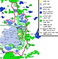
اصل فائل(ایس وی جی فائل، پکسل:۳۸۴ × ۵۸۹، فائل سائز: ۸۸ کلوبائٹ)

ایہ فائل Wikimedia Commons توں اے تے دوجیاں ویونتاں تے وی ورتی جاسکدی اے۔ گل بات اس دے فائل گل بات صفحہ تے تھلے دتی گئی۔

تفصیل

[سودھو]

Deutsch: Karte Jerusalems:
 
Westjerusalem und Skopusberg
 
Waffenstillstandslinie von 1949
 
Altstadt
 
Arabische Viertel in Ostjerusalem
 
Stadtgrenze bis 1967
 
Jüdische Viertel in Ostjerusalem
 
Stadtgrenze
 
Jüdische Gebiete im Westjordanland
 
Arabische Gebiete im Westjordanland
English: Map of Jerusalem:
 
West Jerusalem and Mount Scopus
 
1949 armistice line
 
Old City, fully annexed by Israel
 
East Jerusalem, occupied Arab areas, annexed by Israel
 
Pre-1967 municipal boundary
 
East Jerusalem, Jewish colonies, annexed by Israel
 
Current Israeli extended boundary of the municipality and of the district of Jerusalem
 
West Bank, Jewish colonies in the new district of Samaria and Judea (zone C)
 
West Bank, occupied Arab areas (zone A, partially controled by the Palestinian National Authority)
Español: Mapa de Jerusalén:
 
Jerusalén Oeste y Monte Scopus
 
Frontera de armisticio de 1949
 
Ciudad Vieja
 
Jerusalén Este, áreas árabes
 
Frontera anterior a 1967
 
Jerusalén Este, áreas judías
 
Frontera de Jerusalén
 
Cisjordania, áreas judías
 
Cisjordania, áreas árabes
Français : Carte de Jérusalem :
 
Jérusalem-Ouest et Mont Scopus
 
Ligne d'armistice de 1949
 
Vieille ville, entièrement annexée par Israël
 
Jérusalem-Est, secteurs arabes occupés par Israël
 
Frontière municipale avant 1967
 
Jérusalem-Est, colonies juives annexées par Israël après 1967
 
Frontière actuelle d'extension israélienne de la municipalité et du district de Jérusalem
 
Cisjordanie, colonies juives dans le nouveau district israélien de Samarie et de Judée (zone C)
 
Cisjordanie, secteurs arabes occupés (zone A, partiellement contrôlée par l'Autorité nationale palestinienne)
تریخ
سروت
image extraction process
This file has been extracted from another file
: EastJerusalemMap.jpg
original file
لکھاری Doron, Chabacano
اجازت
(فائل نوں دوبارہ ورتنا)
GNU head کاپی کرن، ونڈن تے بدلن دی ایس ڈوکومنٹ ل‏ئی اجازت دتی جاندی اے ایہناں GNU Free Documentation License, Version 1.2 شرطاں نال یا مگروں کسے وی چھپے ورین Free Software Foundation توں بنا کسے انویرینٹ سیکشن دے، ناں فرنٹ کور لکھت تے ناں بیک کور لکھت دے۔ لسنس دی اک کاپی سیکشن وچ ہیگی اے جہدا ناں اے GNU Free Documentation License۔
w:en:Creative Commons
کس دے ناں اکو جہا شئیر کرو۔
ایس فائل نوں کریٹو کامنز Attribution 2.5 پولینڈ لائسنس دتا گیا.
تہانوں کھلھ اے:
  • حصہ کرنا – کاپی، ونڈنا تے کم بھیجنا
  • فیر رلانا – کم نوں فٹ کرنا
تھلے دتیاں شرطاں نال:
  • کس دے ناں – تسیں لازمی ایس کم دے بناں والے بارے دسو جنج اونے آکھیا اے یا جنج لسنس چ آکھیا گیا ہے۔
  • اکو جہا شئیر کرو۔ – اگر تسیں بدلدے یا ایس کم تے بناندے تے بنن والے کم نوں اینج دے لسنس نال ای ونڈو گے۔
اس لائسنس دا ٹیگ GFDL دے مطابق اس فائل چ پایا گیا اے licensing update۔
دوجے ورژن

[سودھو]

Annotations
InfoField
This image is annotated: View the annotations at Commons

Captions

Add a one-line explanation of what this file represents

Items portrayed in this file

چترن

copyrighted English

۱۱ جون 2007

media type English

image/svg+xml

فائل دی تریخ

فائل نو اس ویلے دی حالت وچ ویکھن واسطے تاریخ/ویلے تے کلک کرو۔

تریخ تے ویلہنکی مورتپاسےورتن والاتیپّݨی کرو
موجودہ۰۵:۵۵, ۱ اگست ۲۰۰۹۰۵:۵۵, ۱ اگست ۲۰۰۹ ویلے دے ورژن ساتھ انگوٹھاکار روپ۳۸۴ × ۵۸۹ (۸۸ کلوبائٹ)Kordastranslated names
۲۳:۳۱, ۲۶ جون ۲۰۰۷۲۳:۳۱, ۲۶ جون ۲۰۰۷ ویلے دے ورژن ساتھ انگوٹھاکار روپ۳۸۴ × ۵۸۹ (۸۷ کلوبائٹ)Ignacio Icke
۰۱:۴۲, ۱۲ جون ۲۰۰۷۰۱:۴۲, ۱۲ جون ۲۰۰۷ ویلے دے ورژن ساتھ انگوٹھاکار روپ۳۸۴ × ۵۸۹ (۸۶ کلوبائٹ)Ignacio Icke{{Information |Description=Mapa de Jerusalén este: {{legend|#ac9f7f|Casco antiguo}} {{legend|#aebbe3|Jerusalén oeste}}{{legend|#5f8af6|Jerusalén este}}{{legend|#0049ee|West bank, áreas judías}}{{legend|#67f96c|Jerusalén este, áreas árabes}}{{legen

تھلے دتے گئے 1 صفحے اس فائل نال جُڑدے نیں

فائل ویاپک ورتوں

ایہہ دوجے وکیاں ایس فائل نوں ورتدے نیں –

ایس فائل دا ویکھو ہور جگت ورتن .
میٹا ڈیٹا