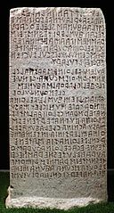
فائل:Cippo perugino, con iscrizione in lingua etrusca su un atto giuridico tra le famiglie dei velthina e degli afuna, 02.jpg

ایس وکھالے دا ناپ: ۳۲۱ × ۵۹۹ پکسلز۔ دوجے ریزولوشنز: ۱۲۸ × ۲۴۰ پکسلز | ۲۵۷ × ۴۸۰ پکسلز | ۴۱۲ × ۷۶۸ پکسلز | ۵۴۹ × ۱,۰۲۴ پکسلز | ۱,۵۵۴ × ۲,۸۹۸ پکسلز ۔
اصل فائل (۱,۵۵۴ × ۲,۸۹۸ پکسلز, فائل حجم: ۳.۵۲ میگابائٹ, MIME type: image/jpeg)
خلاصہ
| تفصیل |
Italiano: Museo Archeologico Nazionale dell'Umbria
|
|||||
| تریخ | ||||||
| سروت | آپݨا کم | |||||
| لکھاری | Sailko |

| Camera location | | View this and other nearby images on: OpenStreetMap |
|---|
لائسنس –
میں، اس کم دے کاپیرائٹ دا مالک، اس کم نوں اس لائسنس دے مطابق چھاپدا واں:
This file is licensed under the Creative Commons Attribution-Share Alike 4.0 International license.
- تہانوں کھلھ اے:
- حصہ کرنا – کاپی، ونڈنا تے کم بھیجنا
- فیر رلانا – کم نوں فٹ کرنا
- تھلے دتیاں شرطاں نال:
- کس دے ناں – تسیں لازمی ایس کم دے بناں والے بارے دسو جنج اونے آکھیا اے یا جنج لسنس چ آکھیا گیا ہے۔
- اکو جہا شئیر کرو۔ – اگر تسیں بدلدے یا ایس کم تے بناندے تے بنن والے کم نوں اینج دے لسنس نال ای ونڈو گے۔

|
This image was uploaded as part of Wiki Loves Monuments 2016.
|
 |

|
The making of this document was supported by Wikimedia CH. (Submit your project!) For all the files concerned, please see the category Supported by Wikimedia CH. |
فائل دی تریخ
فائل نو اس ویلے دی حالت وچ ویکھن واسطے تاریخ/ویلے تے کلک کرو۔
| تریخ تے ویلہ | نکی مورت | پاسے | ورتن والا | تیپّݨی کرو | |
|---|---|---|---|---|---|
| موجودہ | ۲۲:۰۱, ۲۳ ستمبر ۲۰۱۶ | | ۱,۵۵۴ × ۲,۸۹۸ (۳.۵۲ میگابائٹ) | Sailko | User created page with UploadWizard |
فائل دی ورتوں
تھلے دتے گئے 1 صفحے اس فائل نال جُڑدے نیں
فائل ویاپک ورتوں
ایہہ دوجے وکیاں ایس فائل نوں ورتدے نیں –
- als.wikipedia.org تے ورتوں
- ar.wikipedia.org تے ورتوں
- co.wikipedia.org تے ورتوں
- de.wikipedia.org تے ورتوں
- eml.wikipedia.org تے ورتوں
- en.wikipedia.org تے ورتوں
- es.wikipedia.org تے ورتوں
- eu.wikipedia.org تے ورتوں
- fr.wikipedia.org تے ورتوں
- he.wikipedia.org تے ورتوں
- hr.wikipedia.org تے ورتوں
- hu.wikipedia.org تے ورتوں
- hyw.wikipedia.org تے ورتوں
- it.wikipedia.org تے ورتوں
- ja.wikipedia.org تے ورتوں
- la.wikipedia.org تے ورتوں
- lt.wikipedia.org تے ورتوں
- mg.wikipedia.org تے ورتوں
- nl.wikipedia.org تے ورتوں
- no.wikipedia.org تے ورتوں
- oc.wikipedia.org تے ورتوں
- pl.wikipedia.org تے ورتوں
- pl.wiktionary.org تے ورتوں
- pt.wikipedia.org تے ورتوں
ایس فائل دا ویکھو ہور جگت ورتن .