فائل:CarthageMap.png
اس توں وڈی مورت موجود نہیں۔
CarthageMap.png (۷۷۰ × ۴۴۷ پکسلز, فائل حجم: ۱۰۶ کلوبائٹ, MIME type: image/png)
خلاصہ
| تفصیل |
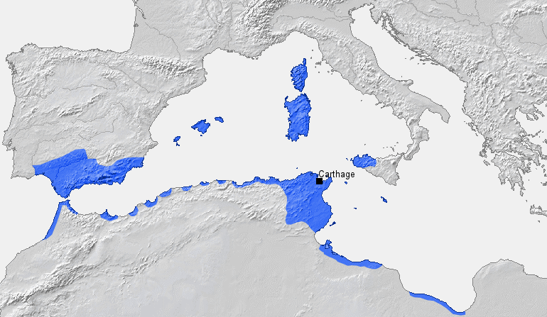
Location of Carthage and Carthaginian sphere of influence prior to the First Punic War (264 BC) Source: Self-made, based on Putzger Atlas und Chronik zur Weltgeschichte, Berlin, 2002 Template: [1] Author: BishkekRocks |
||
| تریخ | ۱۸ مارچ ۲۰۰۶ (original upload date) | ||
| سروت | No machine-readable source provided. Own work assumed (based on copyright claims). | ||
| لکھاری | No machine-readable author provided. BishkekRocks assumed (based on copyright claims). | ||
| دوجے ورژن |
|

لائسنس –
| میں، اس کم دے کاپیرائٹ دا مالک، اس کم نوں لوکاں واسطے دیندا واں۔ اے سارے جگ واسطے لاگو اے۔ کج ملکاں چ قانونی طور تے اے ممکن نئیں اے؛ اگر انج ای اے ے: میں ہر کسے نوں اس کم نوں کسے وی مقصد واسطے ورتن دا بغیر کسے شرط دے حق دیندا واں، اگر اوہ قانون دے خلاف نا ہوۓ۔ |
فائل دی تریخ
فائل نو اس ویلے دی حالت وچ ویکھن واسطے تاریخ/ویلے تے کلک کرو۔
| تریخ تے ویلہ | نکی مورت | پاسے | ورتن والا | تیپّݨی کرو | |
|---|---|---|---|---|---|
| موجودہ | ۰۰:۵۰, ۷ اپریل ۲۰۲۳ | | ۷۷۰ × ۴۴۷ (۱۰۶ کلوبائٹ) | Titanjs | Reverted to version as of 15:31, 18 March 2006 (UTC) |
| ۱۹:۱۶, ۲۳ مارچ ۲۰۱۶ |  | ۷۷۰ × ۴۴۷ (۲۸۸ کلوبائٹ) | Michczu | drobna poprawka | |
| ۲۱:۵۲, ۱۹ ستمبر ۲۰۱۴ |  | ۷۷۰ × ۴۴۷ (۱۲۸ کلوبائٹ) | Daygum | True areas occupied by chartaginians | |
| ۲۰:۳۱, ۱۸ مارچ ۲۰۰۶ |  | ۷۷۰ × ۴۴۷ (۱۰۶ کلوبائٹ) | BishkekRocks | Location of Carthage and Carthaginian influence sphere before the First Punic War (264 BC) Source: Self-made, based on Putzger Atlas und Chronik zur Weltgeschichte, Berlin, 2002 Template: [http://www.demis.nl/wms/mapclip.htm] Author: ~~~ [[Category:Ca |
فائل دی ورتوں
تھلے دتے گئے 1 صفحے اس فائل نال جُڑدے نیں
فائل ویاپک ورتوں
ایہہ دوجے وکیاں ایس فائل نوں ورتدے نیں –
- ar.wikipedia.org تے ورتوں
- ast.wikipedia.org تے ورتوں
- azb.wikipedia.org تے ورتوں
- az.wikipedia.org تے ورتوں
- ba.wikipedia.org تے ورتوں
- be-tarask.wikipedia.org تے ورتوں
- bg.wikipedia.org تے ورتوں
- bm.wikipedia.org تے ورتوں
- br.wikipedia.org تے ورتوں
- bs.wikipedia.org تے ورتوں
- ca.wikipedia.org تے ورتوں
- cdo.wikipedia.org تے ورتوں
- cs.wikipedia.org تے ورتوں
- de.wikipedia.org تے ورتوں
- el.wikipedia.org تے ورتوں
- en.wikipedia.org تے ورتوں
- eo.wikipedia.org تے ورتوں
- es.wikipedia.org تے ورتوں
ایس فائل دا ویکھو ہور جگت ورتن .