فائل:CO2 responsibility 1950-2000.svg

اصل فائل (ایس وی جی فائل، پکسل:۹۴۰ × ۴۷۷، فائل سائز: ۱.۹۸ میگابائٹ)
خلاصہ
| تفصیل |
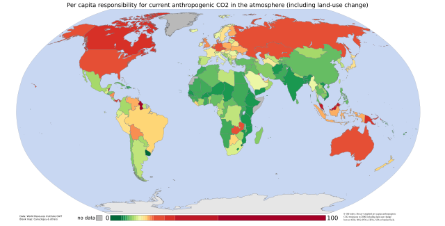
English: Cumulative per capita responsibility for anthropogenic CO2
Data from the World Resources Institute's CAIT 4.0 database (registration required). Includes CO2 emitted up to the year 2000 only (not CH4, N20, PFCs, HFCs or SF6). Estimates of the effects of land-use change are included; bunker-fuel emissions are not. The scale is a 0-100 decay-weighted index. The land-use estimates include the following (list from the relevant CAIT data note):
those of the original ecosystem
of forests in many tropical regions)
estimates include the emissions of carbon from wood products (burned, stored in longterm pools, decayed over time)
Also from the CAIT data note: "It is also important to note that the calculated flux of carbon does not explicitly include changes in carbon stocks that may result from various forms of management. Examples of what is not included are agricultural intensification, fertilization, the trend to no-till agriculture, thinning of forests, changes in species or varieties, and other silvicultural practices." And the data note warns that "these estimates of national sources and sinks of carbon from land-use change are uncertain on the order of +/- 150% for large fluxes, and +/- 50 MtC/yr for estimates near zero." So CAIT's land-use estimates are a bit wild. They are, however, the best currently available at a national level. |
| تریخ | 05/9/07 |
| سروت | self-made using data from the World Resources Institute and a blank map by Canuckguy and others |
| لکھاری | Vinny Burgoo |
لائسنس –

|
کاپی کرن، ونڈن تے بدلن دی ایس ڈوکومنٹ لئی اجازت دتی جاندی اے ایہناں GNU Free Documentation License, Version 1.2 شرطاں نال یا مگروں کسے وی چھپے ورین Free Software Foundation توں بنا کسے انویرینٹ سیکشن دے، ناں فرنٹ کور لکھت تے ناں بیک کور لکھت دے۔ لسنس دی اک کاپی سیکشن وچ ہیگی اے جہدا ناں اے GNU Free Documentation License۔ |
| ایس فائل نوں کریٹو کامنز Attribution 2.5 پولینڈ لائسنس دتا گیا. | ||
| ||
| اس لائسنس دا ٹیگ GFDL دے مطابق اس فائل چ پایا گیا اے licensing update۔ |
فائل دی تریخ
فائل نو اس ویلے دی حالت وچ ویکھن واسطے تاریخ/ویلے تے کلک کرو۔
| تریخ تے ویلہ | نکی مورت | پاسے | ورتن والا | تیپّݨی کرو | |
|---|---|---|---|---|---|
| موجودہ | ۰۴:۲۲, ۵ ستمبر ۲۰۰۷ | | ۹۴۰ × ۴۷۷ (۱.۹۸ میگابائٹ) | Vinny Burgoo | {{Information |Description='''Cumulative per capita responsibility for anthropogenic CO2''' Data from the World Resources Institute's [http://cait.wri.org/ CAIT 4.0 database] (registration required). Includes CO2 only (not CH4, N20, PFCs, HFCs or SF6). E |
فائل دی ورتوں
تھلے دتے گئے 1 صفحے اس فائل نال جُڑدے نیں
فائل ویاپک ورتوں
ایہہ دوجے وکیاں ایس فائل نوں ورتدے نیں –
- ar.wikipedia.org تے ورتوں
- bn.wikipedia.org تے ورتوں
- bs.wikipedia.org تے ورتوں
- ca.wikipedia.org تے ورتوں
- cs.wikipedia.org تے ورتوں
- da.wikipedia.org تے ورتوں
- de.wikipedia.org تے ورتوں
- en.wikipedia.org تے ورتوں
- et.wikipedia.org تے ورتوں
- eu.wikipedia.org تے ورتوں
- fa.wikipedia.org تے ورتوں
- fr.wikipedia.org تے ورتوں
- gu.wikipedia.org تے ورتوں
- ha.wikipedia.org تے ورتوں
- he.wikipedia.org تے ورتوں
- hi.wikipedia.org تے ورتوں
- hy.wikipedia.org تے ورتوں
- mk.wikipedia.org تے ورتوں
- pt.wikipedia.org تے ورتوں
- ru.wikipedia.org تے ورتوں
- so.wikipedia.org تے ورتوں
- ta.wikipedia.org تے ورتوں
- th.wikipedia.org تے ورتوں
- uk.wikipedia.org تے ورتوں
- ur.wikipedia.org تے ورتوں
- vi.wikipedia.org تے ورتوں
- zh.wikipedia.org تے ورتوں