فائل:British main lines railway diagram.png

ایس وکھالے دا ناپ: ۴۲۱ × ۵۹۹ پکسلز۔ دوجے ریزولوشنز: ۱۶۸ × ۲۴۰ پکسلز | ۳۳۷ × ۴۸۰ پکسلز | ۵۳۹ × ۷۶۸ پکسلز | ۷۱۹ × ۱,۰۲۴ پکسلز | ۲,۴۶۴ × ۳,۵۰۸ پکسلز ۔
اصل فائل (۲,۴۶۴ × ۳,۵۰۸ پکسلز, فائل حجم: ۵۵۸ کلوبائٹ, MIME type: image/png)

|
File:British main lines railway diagram.svg is a vector version of this file. It should be used in place of this PNG file when not inferior.
File:British main lines railway diagram.png → File:British main lines railway diagram.svg
For more information, see Help:SVG. |
 |
خلاصہ
| تفصیل |
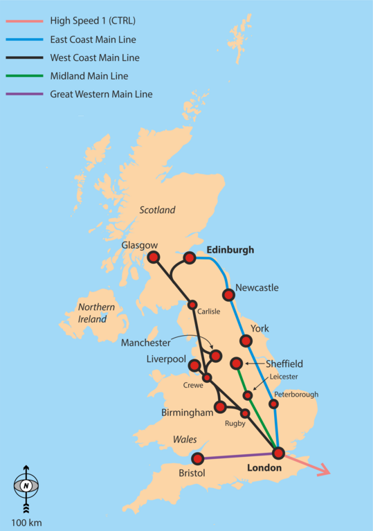
English: Simple overview map of the WCML, ECML, Midland Main Line and CTRL. |
| تریخ | |
| سروت | آپݨا کم |
| لکھاری | Classical geographer |
Background is File:Uk_outline_map.png; ECML and WCML are based on File:Uk outline map with ECML railway.PNG and File:Uk outline map with WCML railway.PNG.
لائسنس –
میں، اس کم دے کاپیرائٹ دا مالک، اس کم نوں اس لائسنس دے مطابق چھاپدا واں:
ایس فائل نوں کریٹو کامنز Attribution 2.5 پولینڈ لائسنس دتا گیا.
- تہانوں کھلھ اے:
- حصہ کرنا – کاپی، ونڈنا تے کم بھیجنا
- فیر رلانا – کم نوں فٹ کرنا
- تھلے دتیاں شرطاں نال:
- کس دے ناں – تسیں لازمی ایس کم دے بناں والے بارے دسو جنج اونے آکھیا اے یا جنج لسنس چ آکھیا گیا ہے۔
- اکو جہا شئیر کرو۔ – اگر تسیں بدلدے یا ایس کم تے بناندے تے بنن والے کم نوں اینج دے لسنس نال ای ونڈو گے۔
فائل دی تریخ
فائل نو اس ویلے دی حالت وچ ویکھن واسطے تاریخ/ویلے تے کلک کرو۔
| تریخ تے ویلہ | نکی مورت | پاسے | ورتن والا | تیپّݨی کرو | |
|---|---|---|---|---|---|
| موجودہ | ۲۲:۲۹, ۶ ستمبر ۲۰۱۶ | | ۲,۴۶۴ × ۳,۵۰۸ (۵۵۸ کلوبائٹ) | Rob984 | Showing all of Ireland but not even part of France is odd. Especially considering there are UK-France high speed routes. |
| ۰۹:۴۸, ۶ ستمبر ۲۰۱۶ |  | ۲,۵۰۳ × ۳,۶۲۷ (۸۴۹ کلوبائٹ) | Classical geographer | Added Western Main Line. Decreased font size of junctions. Note the map is still intended for a quick overview, perhaps at the top of an article. | |
| ۱۲:۲۹, ۲۲ جولائی ۲۰۱۰ |  | ۱,۳۳۳ × ۱,۷۷۷ (۱۸۸ کلوبائٹ) | Classical geographer | Chester should have been Crewe. | |
| ۰۰:۱۷, ۲۲ جولائی ۲۰۱۰ |  | ۱,۶۶۶ × ۲,۲۲۱ (۹۰۴ کلوبائٹ) | Classical geographer | Resized, because was over 12.5 million pixels. | |
| ۰۰:۱۵, ۲۲ جولائی ۲۰۱۰ |  | ۳,۳۳۳ × ۴,۴۴۴ (۶۰۰ کلوبائٹ) | Classical geographer | {{Information |Description={{en|1=Simple overview map of the WCML, ECML, Midland Main Line and CTRL.}} |Source={{own}} |Author=Classical geographer |Date=2010-07-21 |Permission= |other_versions= }} Background is [[:File:Uk_ou |
فائل دی ورتوں
تھلے دتے گئے 1 صفحے اس فائل نال جُڑدے نیں
فائل ویاپک ورتوں
ایہہ دوجے وکیاں ایس فائل نوں ورتدے نیں –
- en.wikipedia.org تے ورتوں
- fa.wikipedia.org تے ورتوں
- it.wikipedia.org تے ورتوں
- ja.wikipedia.org تے ورتوں
- nl.wikipedia.org تے ورتوں
- no.wikipedia.org تے ورتوں
- pt.wikipedia.org تے ورتوں
- ru.wikipedia.org تے ورتوں
- ur.wikipedia.org تے ورتوں
- zh.wikipedia.org تے ورتوں