فائل:BlackSea1600 ru.svg

Size of this PNG preview of this SVG file: ۸۰۰ × ۵۶۷ پکسلز. دوجے ریزولوشنز: ۳۲۰ × ۲۲۷ پکسلز | ۶۴۰ × ۴۵۳ پکسلز | ۱,۰۲۴ × ۷۲۵ پکسلز | ۱,۲۸۰ × ۹۰۶ پکسلز | ۲,۵۶۰ × ۱,۸۱۳ پکسلز | ۷,۰۰۰ × ۴,۹۵۷ پکسلز ۔
اصل فائل (ایس وی جی فائل، پکسل:۷,۰۰۰ × ۴,۹۵۷، فائل سائز: ۳.۳۳ میگابائٹ)
| تفصیل |
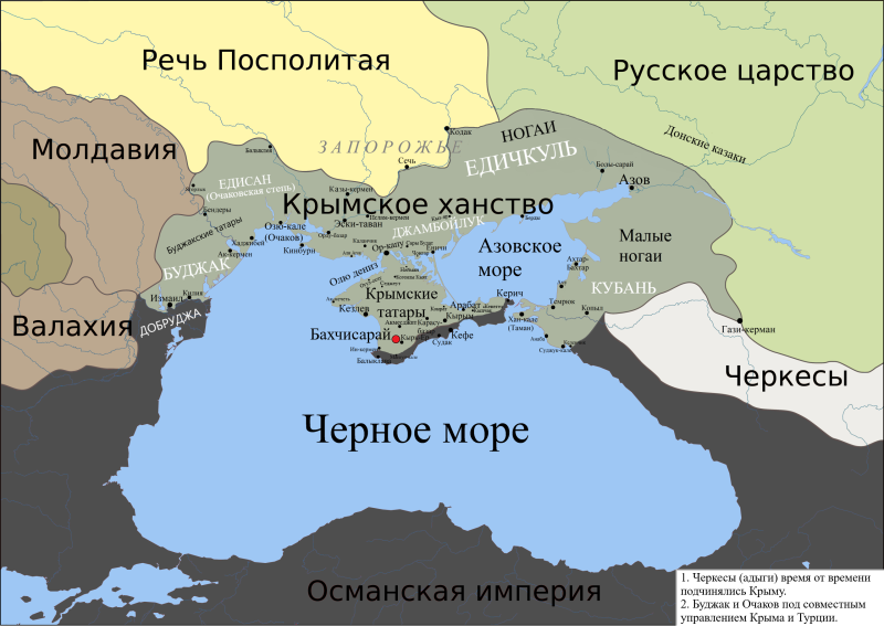
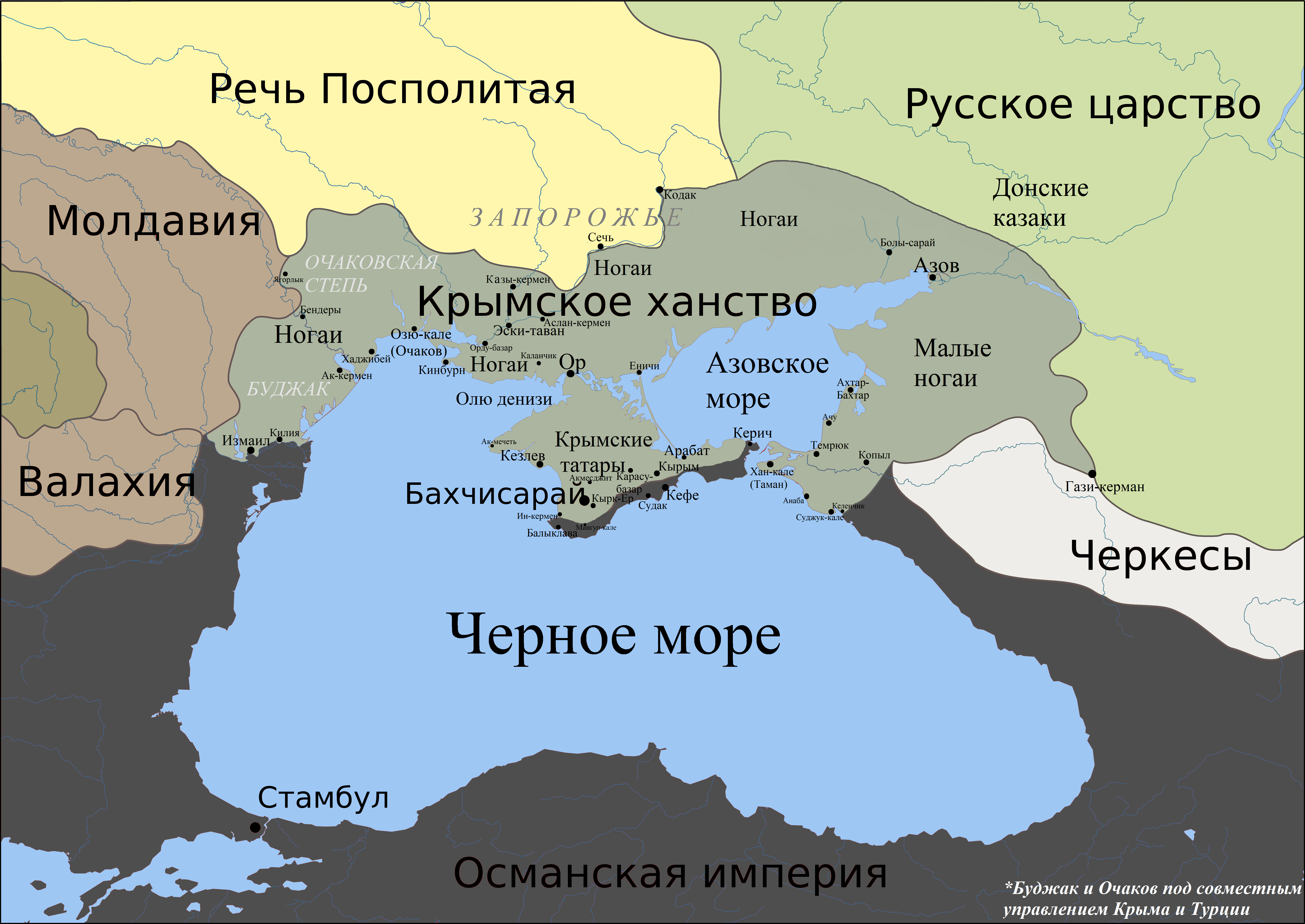
English: Political map of Black Sea region around 1600. |
| تریخ | (UTC) |
| سروت |
used the map from Big Russian Encyclopedia 1600.gif, translated
|
| لکھاری |
|
| دوجے ورژن | Derivative works of this file: BlackSea1600 uk.svg |

|
This SVG file contains embedded text that can be translated into your language, using any capable SVG editor, text editor or the SVG Translate tool. For more information see: About translating SVG files. |
| This is a retouched picture, which means that it has been digitally altered from its original version. The original can be viewed here: BlackSea.svg:
|
ایس فائل نوں کریٹو کامنز Attribution 2.5 پولینڈ لائسنس دتا گیا.
- تہانوں کھلھ اے:
- حصہ کرنا – کاپی، ونڈنا تے کم بھیجنا
- فیر رلانا – کم نوں فٹ کرنا
- تھلے دتیاں شرطاں نال:
- کس دے ناں – تسیں لازمی ایس کم دے بناں والے بارے دسو جنج اونے آکھیا اے یا جنج لسنس چ آکھیا گیا ہے۔
- اکو جہا شئیر کرو۔ – اگر تسیں بدلدے یا ایس کم تے بناندے تے بنن والے کم نوں اینج دے لسنس نال ای ونڈو گے۔
پہلا اپلوڈ دا ریکارڈ
This image is a derivative work of the following images:
- File:1600_rus.gif licensed with PD-self
- 2007-02-22T00:52:20Z Voevoda 450x371 (18989 Bytes) Author: Voevoda, Description: Political map of Black Sea region around 1600 Source: 1600.gif, translated
- File:BlackSea.svg licensed with Cc-by-3.0
- 2010-06-19T05:47:18Z Materialscientist 1771x1254 (3123100 Bytes) {{Information |Description={{ru|1=Создано при помощи [[:en:Generic Mapping Tools|Generic Mapping Tools]], [[:ru:Gimp|GIMP]] и [[:ru:Inkscape|Inkscape]]. Использованы данные [http://topex.ucs
Uploaded with derivativeFX
فائل دی تریخ
فائل نو اس ویلے دی حالت وچ ویکھن واسطے تاریخ/ویلے تے کلک کرو۔
| تریخ تے ویلہ | نکی مورت | پاسے | ورتن والا | تیپّݨی کرو | |
|---|---|---|---|---|---|
| موجودہ | ۱۴:۱۷, ۶ جون ۲۰۲۰ | | ۷,۰۰۰ × ۴,۹۵۷ (۳.۳۳ میگابائٹ) | Devlet Geray | better colours, more accurate |
| ۰۱:۰۷, ۱۱ مئی ۲۰۲۰ |  | ۱,۷۷۱ × ۱,۲۵۴ (۵۹۳ کلوبائٹ) | Devlet Geray | учитывая претензии преследующих | |
| ۰۳:۲۳, ۱۰ مئی ۲۰۲۰ |  | ۱,۷۷۱ × ۱,۲۵۴ (۶۰۵ کلوبائٹ) | Devlet Geray | according to the source, https://bigenc.ru/domestic_history/text/3892808 per Большая Российская Энциклопедия | |
| ۱۲:۵۳, ۲۴ جولائی ۲۰۱۲ |  | ۱,۷۷۱ × ۱,۲۵۴ (۲۱۱ کلوبائٹ) | Urutseg | уточнения имен, небольшая очистка. | |
| ۱۸:۱۰, ۳ نومبر ۲۰۱۰ |  | ۱,۷۷۱ × ۱,۲۵۴ (۲۷۸ کلوبائٹ) | Urutseg | Names' fix | |
| ۱۸:۰۶, ۳ نومبر ۲۰۱۰ |  | ۱,۷۷۱ × ۱,۲۵۴ (۲۷۸ کلوبائٹ) | Urutseg | fixed sea squares | |
| ۱۷:۵۵, ۳ نومبر ۲۰۱۰ |  | ۱,۷۷۱ × ۱,۲۵۴ (۲۲۳ کلوبائٹ) | Urutseg | {{Information |Description={{en|Political map of Black Sea region around 1600.}} |Source=*File:1600_rus.gif *File:BlackSea.svg |Date=2010-11-03 12:53 (UTC) |Author=*File:1600_rus.gif: Voevoda, |Source=1600.gif, translated *[[:File:BlackS |
فائل دی ورتوں
تھلے دتے گئے 1 صفحے اس فائل نال جُڑدے نیں
فائل ویاپک ورتوں
ایہہ دوجے وکیاں ایس فائل نوں ورتدے نیں –
- azb.wikipedia.org تے ورتوں
- ba.wikipedia.org تے ورتوں
- bg.wikipedia.org تے ورتوں
- crh.wikipedia.org تے ورتوں
- en.wikipedia.org تے ورتوں
- es.wikipedia.org تے ورتوں
- hy.wikipedia.org تے ورتوں
- incubator.wikimedia.org تے ورتوں
- it.wikipedia.org تے ورتوں
- ja.wikipedia.org تے ورتوں
- kk.wikipedia.org تے ورتوں
- krc.wikipedia.org تے ورتوں
- ky.wiktionary.org تے ورتوں
- pt.wikipedia.org تے ورتوں
- ru.wikipedia.org تے ورتوں
- Крымское ханство
- Ногайцы
- Запорожская Сечь
- Битва при Молодях
- Русско-крымские войны
- История Крыма
- Депортация крымских татар
- Малые Ногаи
- Северное Причерноморье
- Черкесогаи
- Причерноморье
- Ясырь
- Бакаев шлях
- Список крупнейших государств в истории
- Польско-крымская граница
- Алтыульская Орда
- Присоединение Крыма к Российской империи
- Броневский, Мартин
- Турецкое завоевание Крыма
- Обсуждение шаблона:ПозКарта Россия Республика Крым
- sr.wikipedia.org تے ورتوں
- tt.wikipedia.org تے ورتوں
- uk.wikipedia.org تے ورتوں
- uz.wikipedia.org تے ورتوں
- www.wikidata.org تے ورتوں
- zh.wikipedia.org تے ورتوں