فائل:Australia.A2002231.0145.250m NASA Nullarbor.jpg

اصل فائل (۵,۸۰۰ × ۴,۴۰۰ پکسلز, فائل حجم: ۲.۹۱ میگابائٹ, MIME type: image/jpeg)
خلاصہ
- Credit Jacques Descloitres, MODIS Rapid Response Team, NASA/GSFC
http://visibleearth.nasa.gov/view_rec.php?id=4153 archive copy at the Wayback Machine
Metadata Sensor Terra/MODIS Datastart 2002-08-19 Dataend 2002-08-19 Visible Earth v1 ID 21116 Visualization Date 2002-09-16
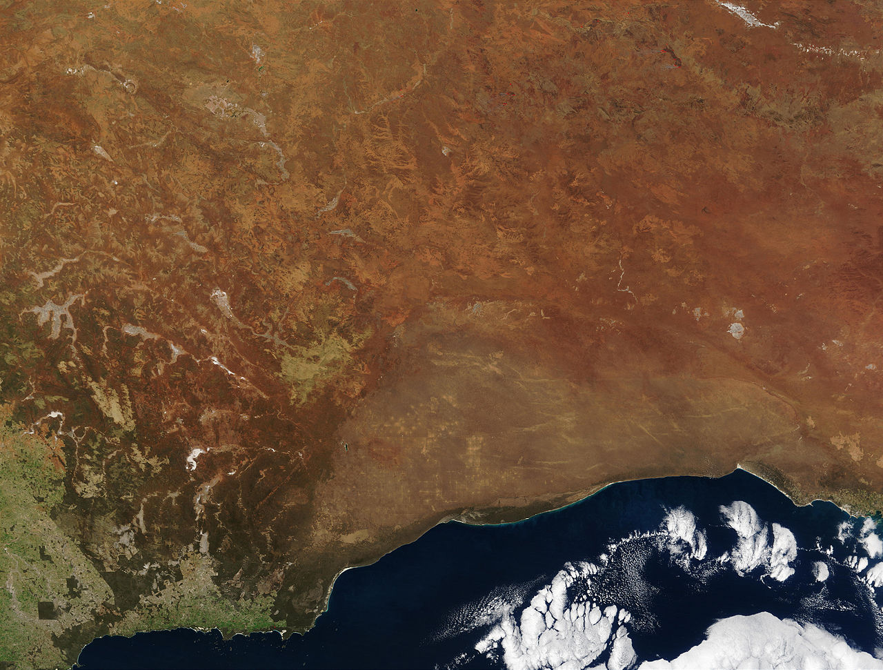
"The striking orange-red colored southern Australian coast contrasts against the deep sapphire-blue waters of the Southern Ocean in this true-color Moderate Resolution Imaging Spectroradiometer (MODIS) image acquired by the Terra satellite on August 19, 2002. In the northern portion of the image, a handful of fires (marked in red) were detected burning in the Great Victoria Desert by the MODIS instrument. South of the desert is the lighter-orange Nullarbor Plain, which stretches for over 1000 kilometers (about 600 miles) from end to end. Finally, just off the coast in the Southern Ocean is the Great Australian Bight, home to Australian Sea Lions, Southern Right Whales, and various fish species."
| This file is in the public domain in the United States because it was solely created by NASA. NASA copyright policy states that "NASA material is not protected by copyright unless noted". (See Template:PD-USGov, NASA copyright policy page or JPL Image Use Policy.) | ||
 |
Warnings:
|
en:Image:Australia.A2002231.0145.250m_NASA_Nullarbor.jpg
لائسنس –
| ایس فائل نوں کریٹو کامنز Attribution 2.5 پولینڈ لائسنس دتا گیا. Subject to disclaimers. | ||
| ||
| اس لائسنس دا ٹیگ GFDL دے مطابق اس فائل چ پایا گیا اے licensing update۔ |

|
کاپی کرن، ونڈن تے بدلن دی ایس ڈوکومنٹ لئی اجازت دتی جاندی اے ایہناں GNU Free Documentation License, Version 1.2 شرطاں نال یا مگروں کسے وی چھپے ورین Free Software Foundation توں بنا کسے انویرینٹ سیکشن دے، ناں فرنٹ کور لکھت تے ناں بیک کور لکھت دے۔ لسنس دی اک کاپی سیکشن وچ ہیگی اے جہدا ناں اے GNU Free Documentation License۔ Subject to disclaimers. |
فائل دی تریخ
فائل نو اس ویلے دی حالت وچ ویکھن واسطے تاریخ/ویلے تے کلک کرو۔
| تریخ تے ویلہ | نکی مورت | پاسے | ورتن والا | تیپّݨی کرو | |
|---|---|---|---|---|---|
| موجودہ | ۰۱:۲۷, ۲۵ اکتوبر ۲۰۰۵ | | ۵,۸۰۰ × ۴,۴۰۰ (۲.۹۱ میگابائٹ) | Albinfo | *Credit Jacques Descloitres, MODIS Rapid Response Team, NASA/GSFC http://visibleearth.nasa.gov/view_rec.php?id=4153 Metadata Sensor Terra/MODIS Datastart 2002-08-19 Dataend 2002-08-19 Visible Earth v1 ID 21116 Visualization Date 2002-09-16 "The |
فائل دی ورتوں
تھلے دتے گئے 1 صفحے اس فائل نال جُڑدے نیں
فائل ویاپک ورتوں
ایہہ دوجے وکیاں ایس فائل نوں ورتدے نیں –
- af.wikipedia.org تے ورتوں
- an.wikipedia.org تے ورتوں
- ar.wikipedia.org تے ورتوں
- arz.wikipedia.org تے ورتوں
- ast.wikipedia.org تے ورتوں
- avk.wikipedia.org تے ورتوں
- az.wikipedia.org تے ورتوں
- ba.wikipedia.org تے ورتوں
- be-tarask.wikipedia.org تے ورتوں
- be.wikipedia.org تے ورتوں
- bg.wikipedia.org تے ورتوں
- bn.wikipedia.org تے ورتوں
- ca.wikipedia.org تے ورتوں
- ceb.wikipedia.org تے ورتوں
- cy.wikipedia.org تے ورتوں
- da.wikipedia.org تے ورتوں
- de.wikipedia.org تے ورتوں
- en.wikipedia.org تے ورتوں
- en.wikiversity.org تے ورتوں
- en.wikivoyage.org تے ورتوں
- eo.wikipedia.org تے ورتوں
- es.wikipedia.org تے ورتوں
- es.wikivoyage.org تے ورتوں
- eu.wikipedia.org تے ورتوں
- fa.wikipedia.org تے ورتوں
- fi.wikipedia.org تے ورتوں
- frr.wikipedia.org تے ورتوں
ایس فائل دا ویکھو ہور جگت ورتن .