فائل:Allied army positions on 10 May 1945.png
ایس وکھالے دا ناپ: ۸۰۰ × ۵۰۶ پکسلز۔ دوجے ریزولوشنز: ۳۲۰ × ۲۰۲ پکسلز | ۶۴۰ × ۴۰۵ پکسلز | ۱,۰۲۴ × ۶۴۸ پکسلز | ۱,۲۱۶ × ۷۶۹ پکسلز ۔
اصل فائل (۱,۲۱۶ × ۷۶۹ پکسلز, فائل حجم: ۵۵۰ کلوبائٹ, MIME type: image/png)

|
This military map image could be re-created using vector graphics as an SVG file. This has several advantages; see Commons:Media for cleanup for more information. If an SVG form of this image is available, please upload it and afterwards replace this template with
{{vector version available|new image name}}.
It is recommended to name the SVG file “Allied army positions on 10 May 1945.svg”—then the template Vector version available (or Vva) does not need the new image name parameter. |
| تفصیل |
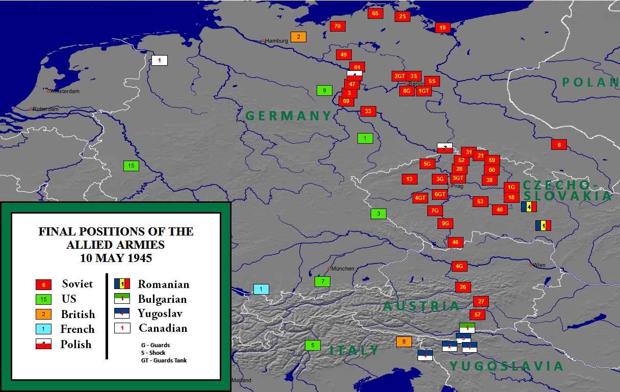
English: Allied army positions on 10 May 1945 |
| تریخ | |
| سروت | http://en.wikipedia.org/wiki/File:Allied_army_positions_on_10_May_1945.png |
| لکھاری | User:W. B. Wilson |
| اجازت (فائل نوں دوبارہ ورتنا) |
میں، اس کم دے کاپیرائٹ دا مالک، اس کم نوں اس لائسنس دے مطابق چھاپدا واں: ایس فائل نوں کریٹو کامنز Attribution 2.5 پولینڈ لائسنس دتا گیا.
|
| دوجے ورژن |
|

پہلا اپلوڈ دا ریکارڈ
The original description page is/was here. All following user names refer to en.wikipedia.
- 17:35, November 8, 2010 W. B. Wilson (294 bytes) (Position of Allied and Soviet armies on 10 May 1945. Made with MapCreator 1.0 software by W. B. Wilson. The maps created with MapCreator 1.0 can be used in all media and require no licence. See http://www.primap.com/en/index.html archive copy at the Wayback Machine for details.)
فائل دی تریخ
فائل نو اس ویلے دی حالت وچ ویکھن واسطے تاریخ/ویلے تے کلک کرو۔
| تریخ تے ویلہ | نکی مورت | پاسے | ورتن والا | تیپّݨی کرو | |
|---|---|---|---|---|---|
| موجودہ | ۰۷:۴۵, ۲ نومبر ۲۰۱۹ | | ۱,۲۱۶ × ۷۶۹ (۵۵۰ کلوبائٹ) | Illegitimate Barrister | typos fixed |
| ۱۹:۰۸, ۳ فروری ۲۰۱۸ |  | ۱,۲۱۶ × ۷۶۹ (۵۱۷ کلوبائٹ) | Ibn Battuta | changing the color scheme to make the French, UK & US armies more visible | |
| ۱۹:۰۳, ۳ فروری ۲۰۱۸ |  | ۱,۲۱۶ × ۷۶۹ (۴۷۸ کلوبائٹ) | Ibn Battuta | changed the Polish icon - it was so close to being the national flag, now it *is* the national flag | |
| ۱۸:۲۳, ۳ فروری ۲۰۱۸ |  | ۱,۲۱۶ × ۷۶۹ (۴۷۸ کلوبائٹ) | Ibn Battuta | deleted "and Soviet" [armies] because the Soviets were part of the Allied armies | |
| ۲۰:۳۹, ۳ مئی ۲۰۱۳ |  | ۱,۲۱۶ × ۷۶۹ (۴۸۱ کلوبائٹ) | GCarty | Corrected the (pre-war) German-Polish border | |
| ۲۱:۱۰, ۲۸ فروری ۲۰۱۳ |  | ۱,۲۱۶ × ۷۶۹ (۵۶۰ کلوبائٹ) | Harriv | Map legend improved by Reddit user [http://www.reddit.com/r/MapPorn/comments/19bsak/final_positions_of_the_allied_and_soviet_armies/c8mp43g BlueInq]. | |
| ۱۱:۰۹, ۷ فروری ۲۰۱۱ |  | ۱,۲۱۷ × ۷۶۹ (۴۶۲ کلوبائٹ) | L'amateur d'aéroplanes | {{Information |Description ={{en|1=Allied army positions on 20 May 1945}} |Source =http://www.ibiblio.org/hyperwar/AAF/III/maps/AAF-III-map_564.jpg |Author =Inconnu |Date =2010 |Permission ={{PD-USGov-Military-Air_Force}} |
فائل دی ورتوں
تھلے دتے گئے 1 صفحے اس فائل نال جُڑدے نیں
فائل ویاپک ورتوں
ایہہ دوجے وکیاں ایس فائل نوں ورتدے نیں –
- ar.wikipedia.org تے ورتوں
- azb.wikipedia.org تے ورتوں
- be-tarask.wikipedia.org تے ورتوں
- bg.wikipedia.org تے ورتوں
- bn.wikipedia.org تے ورتوں
- de.wikipedia.org تے ورتوں
- el.wikipedia.org تے ورتوں
- en.wikipedia.org تے ورتوں
- es.wikipedia.org تے ورتوں
- fa.wikipedia.org تے ورتوں
- fr.wikipedia.org تے ورتوں
- he.wikipedia.org تے ورتوں
- it.wikipedia.org تے ورتوں
- ja.wikipedia.org تے ورتوں
- ka.wikipedia.org تے ورتوں
- ko.wikipedia.org تے ورتوں
- ms.wikipedia.org تے ورتوں
- nl.wikipedia.org تے ورتوں
- no.wikipedia.org تے ورتوں
- pl.wikipedia.org تے ورتوں
- pt.wikipedia.org تے ورتوں
- ro.wikipedia.org تے ورتوں
- ru.wikipedia.org تے ورتوں
- sh.wikipedia.org تے ورتوں
- th.wikipedia.org تے ورتوں
- tr.wikipedia.org تے ورتوں
- uk.wikipedia.org تے ورتوں
- ur.wikipedia.org تے ورتوں
- vi.wikipedia.org تے ورتوں
- xmf.wikipedia.org تے ورتوں
- zh.wikipedia.org تے ورتوں