فائل:Aldwych, Bush House, WC2 - geograph.org.uk - 668798.jpg
اس توں وڈی مورت موجود نہیں۔
Aldwych,_Bush_House,_WC2_-_geograph.org.uk_-_668798.jpg (۶۴۰ × ۴۷۵ پکسلز, فائل حجم: ۸۷ کلوبائٹ, MIME type: image/jpeg)
خلاصہ
| تفصیل |
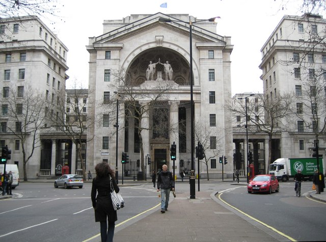
English: Aldwych: Bush House, WC2 The description of Bush House on the BBC's website is concise and informative http://www.bbc.co.uk/heritage/in_depth/buildings/bush_house.shtml
All I would add is that the blue flag flying on the top of Bush House in this image is that of the BBC World Service. The lack of symmetry in the road layout, where there is a wide southbound carriageway and a narrow northbound carriageway, can be explained by the fact that some northbound traffic here is running in the Strand Underpass, which is directly beneath the photographer, and that there is no southbound equivalent. See 668779 for a view in the reverse direction from this viewpoint. |
| تریخ | |
| سروت | From geograph.org.uk |
| لکھاری | Nigel Cox |
| کس دے ناں (required by the license) | Nigel Cox / Aldwych: Bush House, WC2 / |
| Camera location | | View this and other nearby images on: OpenStreetMap |
|---|
_heading:157.00&language=pnb)
| Object location | | View this and other nearby images on: OpenStreetMap |
|---|
_heading:157.00&language=pnb)
لائسنس –

|
This image was taken from the Geograph project collection. See this photograph's page on the Geograph website for the photographer's contact details. The copyright on this image is owned by Nigel Cox and is licensed for reuse under the Creative Commons Attribution-ShareAlike 2.0 license.
|
ایس فائل نوں کریٹو کامنز Attribution 2.0 جنرک لائسنس دتا گیا.
کس دے ناں: Nigel Cox
- تہانوں کھلھ اے:
- حصہ کرنا – کاپی، ونڈنا تے کم بھیجنا
- فیر رلانا – کم نوں فٹ کرنا
- تھلے دتیاں شرطاں نال:
- کس دے ناں – تسیں لازمی ایس کم دے بناں والے بارے دسو جنج اونے آکھیا اے یا جنج لسنس چ آکھیا گیا ہے۔
- اکو جہا شئیر کرو۔ – اگر تسیں بدلدے یا ایس کم تے بناندے تے بنن والے کم نوں اینج دے لسنس نال ای ونڈو گے۔
فائل دی تریخ
فائل نو اس ویلے دی حالت وچ ویکھن واسطے تاریخ/ویلے تے کلک کرو۔
| تریخ تے ویلہ | نکی مورت | پاسے | ورتن والا | تیپّݨی کرو | |
|---|---|---|---|---|---|
| موجودہ | ۲۲:۴۲, ۷ فروری ۲۰۱۱ | | ۶۴۰ × ۴۷۵ (۸۷ کلوبائٹ) | GeographBot | == {{int:filedesc}} == {{Information |description={{en|1=Aldwych: Bush House, WC2 The description of Bush House on the BBC's website is concise and informative http://www.bbc.co.uk/heritage/in_depth/buildings/bush_house.shtml All I would add is that the |
فائل دی ورتوں
تھلے دتے گئے 1 صفحے اس فائل نال جُڑدے نیں
فائل ویاپک ورتوں
ایہہ دوجے وکیاں ایس فائل نوں ورتدے نیں –
- bn.wikipedia.org تے ورتوں
- en.wikipedia.org تے ورتوں
- hu.wikipedia.org تے ورتوں
- hy.wikipedia.org تے ورتوں
- it.wikipedia.org تے ورتوں
- pt.wikipedia.org تے ورتوں
- ru.wikipedia.org تے ورتوں
- sv.wikipedia.org تے ورتوں
- ur.wikipedia.org تے ورتوں
- uz.wikipedia.org تے ورتوں