فائل:Abkhazia detail map2.png
Abkhazia_detail_map2.png (۶۰۰ × ۴۵۰ پکسلز, فائل حجم: ۸۷ کلوبائٹ, MIME type: image/png)
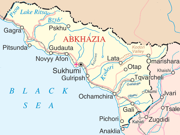
Map of Abkhazia. Modified by Bestalex
Sources
- Primary: http://www.un.org/Depts/Cartographic/map/profile/georgia.pdf
- Secondary http://en.wikipedia.org/wiki/Image:Abkhazia_detail_map.png
| This image is a map derived from a United Nations map.
Unless stated otherwise, UN maps are to be considered in the public domain. This applies worldwide. UN maps are, in principle, open source material and you can use them in your work or for making your own map. UN requests however that you delete the UN name, logo and reference number upon any modification to the map. Content of your map will be your responsibility. You can state in your publication, if you wish, something like: based on UN map … (map name, map number, revision number and date). See: Geospatial Information Section. And: Geospatial, location data for a better world. |
 |
فائل دی تریخ
فائل نو اس ویلے دی حالت وچ ویکھن واسطے تاریخ/ویلے تے کلک کرو۔
| تریخ تے ویلہ | نکی مورت | پاسے | ورتن والا | تیپّݨی کرو | |
|---|---|---|---|---|---|
| موجودہ | ۲۳:۳۱, ۲۲ جون ۲۰۰۸ | | ۶۰۰ × ۴۵۰ (۸۷ کلوبائٹ) | Bestalex | {{Information |Description={{en|1=v}} {{ru|1=v}} |Source=v |Author=v |Date= |Permission= |other_versions= }} {{ImageUpload|full}} |
فائل دی ورتوں
تھلے دتے گئے 1 صفحے اس فائل نال جُڑدے نیں
فائل ویاپک ورتوں
ایہہ دوجے وکیاں ایس فائل نوں ورتدے نیں –
- af.wikipedia.org تے ورتوں
- ar.wikipedia.org تے ورتوں
- arz.wikipedia.org تے ورتوں
- ast.wikipedia.org تے ورتوں
- azb.wikipedia.org تے ورتوں
- az.wikipedia.org تے ورتوں
- az.wiktionary.org تے ورتوں
- ba.wikipedia.org تے ورتوں
- be.wikipedia.org تے ورتوں
- ca.wikipedia.org تے ورتوں
- ceb.wikipedia.org تے ورتوں
- ckb.wikipedia.org تے ورتوں
- cs.wikipedia.org تے ورتوں
- de.wikipedia.org تے ورتوں
- el.wikipedia.org تے ورتوں
- en.wikipedia.org تے ورتوں
- Bzyb (river)
- 2006 Kodori crisis
- Geography of Abkhazia
- User:Alaexis/Abkhazwogallery
- Battle of Gagra
- User:Pocopocopocopoco/I1
- User:Pocopocopocopoco/I2
- Kelasuri Wall
- Portal:Georgia (country)/Selected article/2
- Otapi
- Category:Populated places in Abkhazia
- United Nations Security Council Resolution 1124
- List of airports in Abkhazia
- Template:WikiProject Asia
- United Nations Security Council Resolution 1656
- Template:WikiProject Asia/sandbox
- en.wikinews.org تے ورتوں
ایس فائل دا ویکھو ہور جگت ورتن .