فائل:1700 CE world map.PNG

ایس وکھالے دا ناپ: ۸۰۰ × ۳۹۷ پکسلز۔ دوجے ریزولوشنز: ۳۲۰ × ۱۵۹ پکسلز | ۶۴۰ × ۳۱۸ پکسلز | ۱,۰۲۴ × ۵۰۸ پکسلز | ۱,۲۸۰ × ۶۳۵ پکسلز | ۲,۵۶۰ × ۱,۲۷۱ پکسلز | ۴,۵۰۰ × ۲,۲۳۴ پکسلز ۔
اصل فائل (۴,۵۰۰ × ۲,۲۳۴ پکسلز, فائل حجم: ۳۶۴ کلوبائٹ, MIME type: image/png)
خلاصہ
| تفصیل |
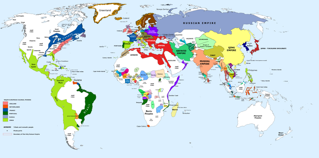
English: 1700 AD: An illustrative map of the world in the early colonial period. The Mughal Empire in India is at its greatest territorial extent. |
||
| تریخ | |||
| سروت | Own work. Blank map from File:World_Map_Blank.svg. | ||
| لکھاری | Urnanabha | ||
| دوجے ورژن |
|

| Maps of world history | |
| BC | |
|
| |
| AD |
1 · 50 · 100 · 200 · 250 · 300 · 400 · 500 · 700 · 750 · 820 · 900 · 1200 · 1500 · 1556 · 1648 · 1700 · 1750 · 1815 · 1859 · 1871 · 1914 · 1935 · 1954 · 1989 · 2000 · |
|
Maps of colonization history | |
|
see also: Eastern Hemisphere only maps template (1300BC-1500AD) | |
| (this template: · view · discuss ) | |
.jpg)
._LOC_2001620596.jpg)
لائسنس –
میں، اس کم دے کاپیرائٹ دا مالک، اس کم نوں اس لائسنس دے مطابق چھاپدا واں:
ایس فائل نوں کریٹو کامنز Attribution 2.5 پولینڈ لائسنس دتا گیا.
- تہانوں کھلھ اے:
- حصہ کرنا – کاپی، ونڈنا تے کم بھیجنا
- فیر رلانا – کم نوں فٹ کرنا
- تھلے دتیاں شرطاں نال:
- کس دے ناں – تسیں لازمی ایس کم دے بناں والے بارے دسو جنج اونے آکھیا اے یا جنج لسنس چ آکھیا گیا ہے۔
- اکو جہا شئیر کرو۔ – اگر تسیں بدلدے یا ایس کم تے بناندے تے بنن والے کم نوں اینج دے لسنس نال ای ونڈو گے۔
فائل دی تریخ
فائل نو اس ویلے دی حالت وچ ویکھن واسطے تاریخ/ویلے تے کلک کرو۔
| تریخ تے ویلہ | نکی مورت | پاسے | ورتن والا | تیپّݨی کرو | |
|---|---|---|---|---|---|
| موجودہ | ۱۵:۰۰, ۲۹ مارچ ۲۰۲۳ | | ۴,۵۰۰ × ۲,۲۳۴ (۳۶۴ کلوبائٹ) | Yourlocallordandsavior | Slightly adjusted Mainland SE Asia borders. |
| ۰۶:۴۹, ۲۸ فروری ۲۰۱۹ |  | ۴,۵۰۰ × ۲,۲۳۴ (۳۸۰ کلوبائٹ) | KnightxxArrow | Fixed inaccurate Cambodian border. | |
| ۰۳:۳۷, ۵ اپریل ۲۰۱۷ |  | ۴,۵۰۰ × ۲,۲۳۴ (۴۰۱ کلوبائٹ) | Chamboz | Fixed wildly inaccurate Ottoman southern border. | |
| ۰۵:۱۰, ۲۶ جنوری ۲۰۱۴ |  | ۴,۵۰۰ × ۲,۲۳۴ (۳۲۸ کلوبائٹ) | Ukabia | Added states | |
| ۰۲:۳۱, ۲۵ جنوری ۲۰۱۴ |  | ۴,۵۰۰ × ۲,۲۳۴ (۳۸.۳۶ میگابائٹ) | Ukabia | Added African states | |
| ۱۰:۳۶, ۱۳ جنوری ۲۰۱۳ |  | ۴,۵۰۰ × ۲,۲۳۴ (۳۲۵ کلوبائٹ) | Urnanabha | User created page with UploadWizard |
فائل دی ورتوں
تھلے دتے گئے 1 صفحے اس فائل نال جُڑدے نیں
فائل ویاپک ورتوں
ایہہ دوجے وکیاں ایس فائل نوں ورتدے نیں –
- azb.wikipedia.org تے ورتوں
- bs.wikipedia.org تے ورتوں
- ce.wikipedia.org تے ورتوں
- de.wikipedia.org تے ورتوں
- en.wikipedia.org تے ورتوں
- eo.wikipedia.org تے ورتوں
- es.wikipedia.org تے ورتوں
- et.wikipedia.org تے ورتوں
- eu.wikipedia.org تے ورتوں
- fi.wikipedia.org تے ورتوں
- fr.wikipedia.org تے ورتوں
- gl.wikipedia.org تے ورتوں
- he.wikipedia.org تے ورتوں
- hy.wikipedia.org تے ورتوں
- id.wikipedia.org تے ورتوں
- io.wikipedia.org تے ورتوں
- it.wikipedia.org تے ورتوں
- it.wikiquote.org تے ورتوں
- ja.wikipedia.org تے ورتوں
- lv.wikipedia.org تے ورتوں
- my.wikipedia.org تے ورتوں
- pap.wikipedia.org تے ورتوں
- ro.wikipedia.org تے ورتوں
- ru.wikipedia.org تے ورتوں
- shn.wikipedia.org تے ورتوں
- te.wikipedia.org تے ورتوں
- ur.wikipedia.org تے ورتوں
- vi.wikipedia.org تے ورتوں