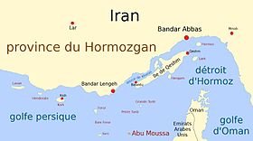
جزیرہ ابو موسی
| ||||
|---|---|---|---|---|
 |
||||
| لمبائی | 5.0 کلومیٹر | |||
| نقشہ | 25°52′33″N 55°02′10″E / 25.875833333333°N 55.036111111111°E | |||
 نقشہ |
||||
| انتظامی تقسیم | ||||
| ملک | ||||
| توں وکھ | ابو موسی | |||
| حصہ | جزیرہ ، متنازعہ علاقہ | |||
| وقوع تھاں | شہرستان ابو موسی | |||
| لمبائی | 5.0 کلومیٹر | |||
| تقسیم اعلیٰ | شہرستان ابو موسی | |||
| جغرافیائی خصوصیات | ||||
| متناسقات | 25°52′33″N 55°02′10″E / 25.875833333333°N 55.036111111111°E | |||
| رقبہ | 12 مربع کلومیٹر | |||
| بلندی | 110 میٹر | |||
| آبادی | ||||
| کل آبادی | 4213 | |||
| مزید معلومات | ||||
| اوقات | متناسق عالمی وقت+03:30 | |||
| جیو رمز | 292983[۳] | |||
|
|
||||
| ترمیم | ||||
| متنازع جزیرہ ہور نام: فارسی: ابوموسی | |
|---|---|

| |
| ابو موسی خلیج فارس وچ | |
| جغرافیہ | |
| مقام | خلیج فارس |
| متناسقات | 25°52′N 55°02′E / 25.867°N 55.033°E |
| کل جزیرے | 1 |
| رقبہ | ۱۲٫۸ کلومیٹر2 (۱۳۸٬۰۰۰٬۰۰۰ فٹ مربع) |
| بلند ترین نقطہ | کوہ حلوا ۱۱۰ میٹر (۳۶۰ فٹ) |
| زیر انتظام | |
| صوبہ | صوبہ ہرمزگان |
| سب توں وڈا شہر | ابو موسی (1,953) |
| دعوی | |
| امارت | شارجہ |
| آبادیات | |
| آبادی | 2,131 (as of 2012) |
| نسلی گروہ | ایرانی |
ابو موسی (Abu Musa)
(فارسی: ابوموسی ![]() listen (help·info)) مشرقی خلیج فارس وچ آبنائے ہرمز دے دھانے دے نیڑے اک ایرانی جزیرہ اے۔[۴]
سمندر دی گہرائی دی وجہ توں وڈے بحری جہازاں تے تیل بردار جہازاں نوں ابو موسی تے تنب اکبر و اصغر دے درمیان توں گزرنا پڑدا اے جس دی اوہ توں ایہ جزیرے خلیج فارس وچ کلید ی مقا م رکھدے نيں۔[۵]
جزیرہ ایران دے زیر انتظام بطور حصہ صوبہ ہرمزگان اے، جدوں کہ متحدہ عرب امارات دا اس اُتے دعوی بطور امارت شارجہ دا علاقہ اے۔[۶][۷]
listen (help·info)) مشرقی خلیج فارس وچ آبنائے ہرمز دے دھانے دے نیڑے اک ایرانی جزیرہ اے۔[۴]
سمندر دی گہرائی دی وجہ توں وڈے بحری جہازاں تے تیل بردار جہازاں نوں ابو موسی تے تنب اکبر و اصغر دے درمیان توں گزرنا پڑدا اے جس دی اوہ توں ایہ جزیرے خلیج فارس وچ کلید ی مقا م رکھدے نيں۔[۵]
جزیرہ ایران دے زیر انتظام بطور حصہ صوبہ ہرمزگان اے، جدوں کہ متحدہ عرب امارات دا اس اُتے دعوی بطور امارت شارجہ دا علاقہ اے۔[۶][۷]
باہرلے جوڑ
سودھو| وکیمیڈیا کامنز چ مورتاں: جزیرہ ابو موسی |
- History, description, map of Abu Musa and nearby islands(Archived 2009-10-26 at the وے بیک مشین 2009-10-24)
- History of Abu Musa and The TunbsArchived 2006-01-06 at the وے بیک مشین
- UAE Interact Abu Musa NewsArchived 2011-05-25 at the وے بیک مشین
- Abu Musa's military garrison
- Dispute between Iran and Sharjah
- Report of the International symposium on Modern Boundaries of Iran – Problems and practices of Iranian boundariesArchived 2019-08-27 at the وے بیک مشین, Pirouz Mojtahed-Zadeh, 10/15/02
حوالے
سودھو- ↑ http://www.washingtoninstitute.org/policy-analysis/view/unwanted-guest-the-gulf-summit-and-iran
- ↑ صفحہ سانچہ:نام صفحہ في GeoNames ID at sws.geonames.org Error: unknown archive URL (archived [Date missing])
- ↑ وصلة : http://geonames.org/292983 — اجازت نامہ: Creative Commons Attribution 3.0 Unported
- ↑ Lua error in ماڈیول:Citation/CS1/Date_validation/ar at line 45: attempt to compare number with nil.
- ↑ (1993) An atlas of world political flashpoints: a sourcebook of geopolitical crisis. Pinter Reference, 1. ISBN 978-1-85567-053-2.
- ↑ Fred M. Shelley (30 اپریل 2013). Nation Shapes: The Story Behind the World's Borders. ABC-CLIO, 457–. ISBN 978-1-61069-106-2. “However, the United Arab Emirates and Iran dispute control over the islands of Abu Musa, Greater Tunb, and Lesser Tunb.”
- ↑ (2001) United Arab Emirates: A New Perspective. Trident Press Ltd, 182–. ISBN 978-1-900724-47-0. “Iran claims Abu Musa Territorial and political ambitions, combined with the economic interests of influential elements within the government, helped strengthen the first Iranian claim to the island of Abu Musa in 1904. Iran began to challenge …”


