فائل:Yugoslavia ethnic map.jpg
ایس وکھالے دا ناپ: ۵۷۴ × ۵۹۹ پکسلز۔ دوجے ریزولوشنز: ۲۳۰ × ۲۴۰ پکسلز | ۴۶۰ × ۴۸۰ پکسلز | ۷۳۶ × ۷۶۸ پکسلز | ۹۸۱ × ۱,۰۲۴ پکسلز | ۱,۶۴۳ × ۱,۷۱۵ پکسلز ۔
اصل فائل (۱,۶۴۳ × ۱,۷۱۵ پکسلز, فائل حجم: ۸۳۷ کلوبائٹ, MIME type: image/jpeg)

|
This ethnographic map image could be re-created using vector graphics as an SVG file. This has several advantages; see Commons:Media for cleanup for more information. If an SVG form of this image is available, please upload it and afterwards replace this template with
{{vector version available|new image name}}.
It is recommended to name the SVG file “Yugoslavia ethnic map.svg”—then the template Vector version available (or Vva) does not need the new image name parameter. |


Српски / srpski: jugoslawija
English: yugoslavia
Français : yougoslavie
Deutsch: jugoslawien
خلاصہ
| تفصیل |
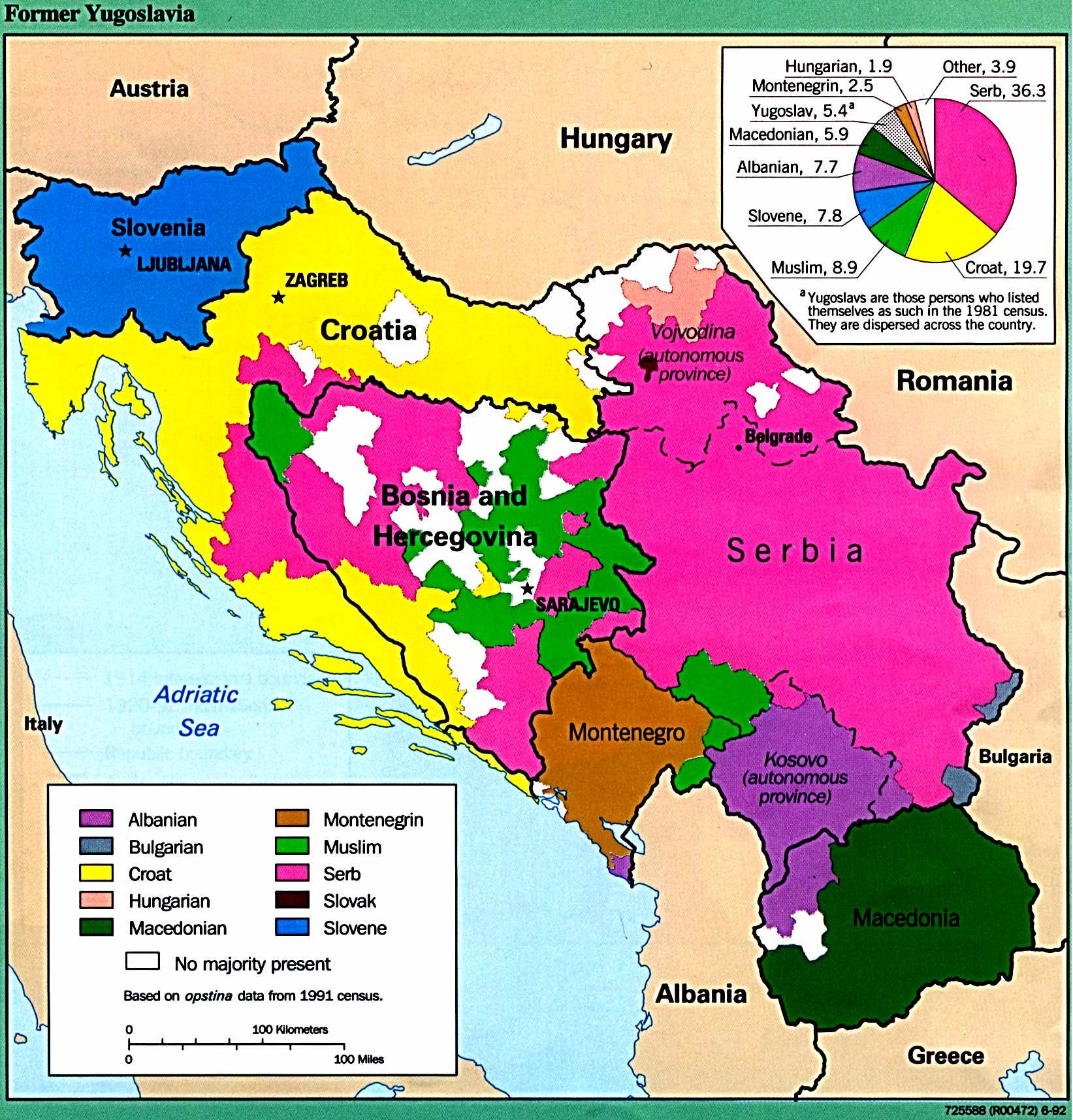
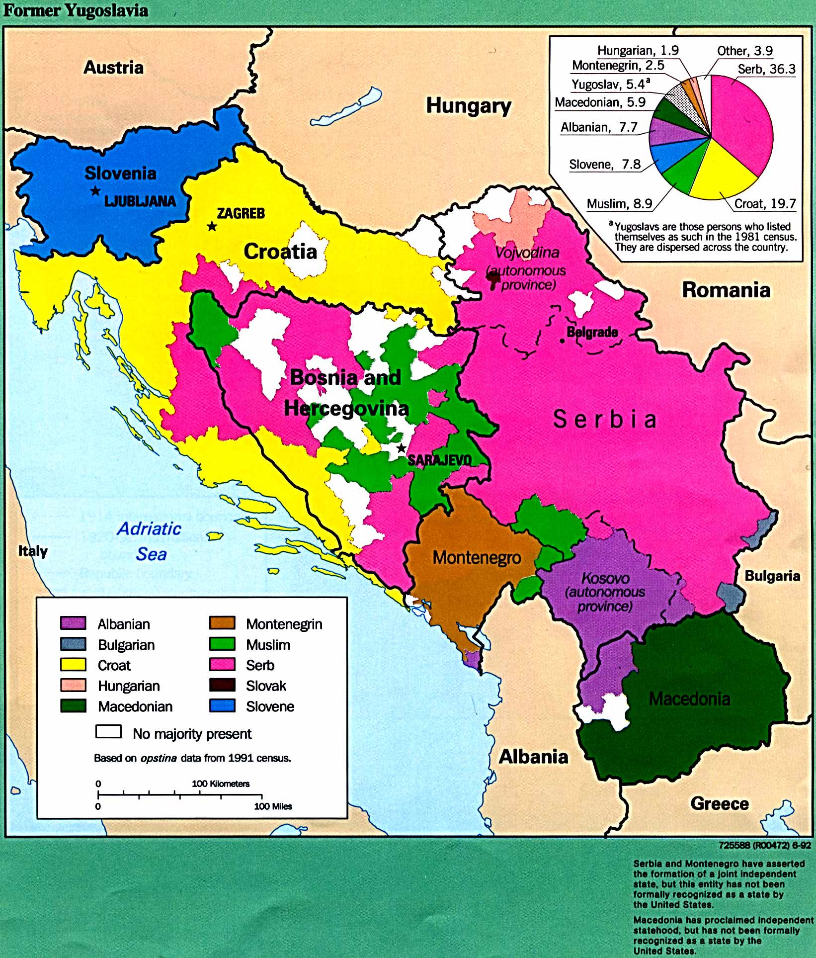
English: Ethnic map of Yugoslavia based on 1991 census data. |
| تریخ | |
| سروت | http://www.lib.utexas.edu/maps/europe/yugoslav.jpg |
| لکھاری | The Former Yugoslavia: A Map Folio, published by the U.S. Central Intelligence Agency in 1992. |
| اجازت (فائل نوں دوبارہ ورتنا) |
Most of the maps scanned by the University of Texas Libraries and served from this web site are in the public domain. No permissions are needed to copy them. You may download them and use them as you wish. A few maps are copyrighted, and are clearly marked as such. [1] |
لائسنس –
This work is in the public domain in the United States because it is a work prepared by an officer or employee of the United States Government as part of that person’s official duties under the terms of Title 17, Chapter 1, Section 105 of the US Code.
Note: This only applies to original works of the Federal Government and not to the work of any individual U.S. state, territory, commonwealth, county, municipality, or any other subdivision. This template also does not apply to postage stamp designs published by the United States Postal Service since 1978. (See § 313.6(C)(1) of Compendium of U.S. Copyright Office Practices). It also does not apply to certain US coins; see The US Mint Terms of Use.
|
 | |
| ایہ فائل دے بارے چ دس اے جے اے کاپی حف دیاں روکاں توں کھلی اے تے نالدے رلدے حقاں توں وی۔ | ||
فائل دی تریخ
فائل نو اس ویلے دی حالت وچ ویکھن واسطے تاریخ/ویلے تے کلک کرو۔
| تریخ تے ویلہ | نکی مورت | پاسے | ورتن والا | تیپّݨی کرو | |
|---|---|---|---|---|---|
| موجودہ | ۰۲:۵۵, ۸ جولائی ۲۰۱۲ | | ۱,۶۴۳ × ۱,۷۱۵ (۸۳۷ کلوبائٹ) | Kontrollstellekundl | old test deleted, + categories |
| ۱۰:۴۲, ۲۳ دسمبر ۲۰۰۶ |  | ۱,۶۴۲ × ۱,۹۲۷ (۴۰۳ کلوبائٹ) | El Cazangero | {{Information |Description=Yugoslav ethnic map according to census 1981 |Source=http://www.lib.utexas.edu/maps/europe/yugoslav.jpg |Date=12/23/2006 |Author=CIA |Permission= |other_versions= }} |
فائل دی ورتوں
تھلے دتے گئے 1 صفحے اس فائل نال جُڑدے نیں
فائل ویاپک ورتوں
ایہہ دوجے وکیاں ایس فائل نوں ورتدے نیں –
- ar.wikipedia.org تے ورتوں
- ast.wikipedia.org تے ورتوں
- be.wikipedia.org تے ورتوں
- ca.wikipedia.org تے ورتوں
- cs.wikipedia.org تے ورتوں
- cy.wikipedia.org تے ورتوں
- de.wikipedia.org تے ورتوں
- el.wikipedia.org تے ورتوں
- en.wikipedia.org تے ورتوں
- es.wikipedia.org تے ورتوں
- fi.wikipedia.org تے ورتوں
- fr.wikipedia.org تے ورتوں
- hr.wikipedia.org تے ورتوں
- hu.wikipedia.org تے ورتوں
- id.wikipedia.org تے ورتوں
- it.wikipedia.org تے ورتوں
- mk.wikipedia.org تے ورتوں
- my.wikipedia.org تے ورتوں
- nl.wikipedia.org تے ورتوں
- pt.wikipedia.org تے ورتوں
- ro.wikipedia.org تے ورتوں
- ru.wikipedia.org تے ورتوں
- sh.wikipedia.org تے ورتوں
- sl.wikipedia.org تے ورتوں
- sr.wikibooks.org تے ورتوں
- uk.wikipedia.org تے ورتوں
- ur.wikipedia.org تے ورتوں
- www.wikidata.org تے ورتوں