فائل:We-map.png

ایس وکھالے دا ناپ: ۲۷۵ × ۶۰۰ پکسلز۔ دوجے ریزولوشنز: ۱۱۰ × ۲۴۰ پکسلز | ۳۲۶ × ۷۱۱ پکسلز ۔
اصل فائل (۳۲۶ × ۷۱۱ پکسلز, فائل حجم: ۲۲ کلوبائٹ, MIME type: image/png)
خلاصہ
| تفصیل |
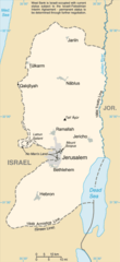
English: Replacement map of the West Bank from CIA Factbook |
| سروت | The original GIF image source for this map is: archive copy at the Wayback Machine |
| لکھاری | This PNG image was copied from en.wikipedia.org. |
This image is in the public domain because it contains materials that originally came from the United States Central Intelligence Agency's World Factbook.
|
 |
فائل دی تریخ
فائل نو اس ویلے دی حالت وچ ویکھن واسطے تاریخ/ویلے تے کلک کرو۔
| تریخ تے ویلہ | نکی مورت | پاسے | ورتن والا | تیپّݨی کرو | |
|---|---|---|---|---|---|
| موجودہ | ۱۸:۵۶, ۲۵ مارچ ۲۰۱۰ | | ۳۲۶ × ۷۱۱ (۲۲ کلوبائٹ) | Ras67 | cropped |
| ۱۷:۳۵, ۱۵ ستمبر ۲۰۰۴ |  | ۳۳۰ × ۷۱۵ (۲۳ کلوبائٹ) | Robbot | This image was copied from en.wikipedia.org. The original description was: Replacement map of the West Bank from CIA Factbook - public domain en:Image:We-map.png {{PD-USgov}} |
فائل دی ورتوں
تھلے دتے گئے 1 صفحے اس فائل نال جُڑدے نیں
فائل ویاپک ورتوں
ایہہ دوجے وکیاں ایس فائل نوں ورتدے نیں –
- af.wikipedia.org تے ورتوں
- als.wikipedia.org تے ورتوں
- ar.wikinews.org تے ورتوں
- ast.wikipedia.org تے ورتوں
- be-tarask.wikipedia.org تے ورتوں
- be.wikipedia.org تے ورتوں
- bg.wikipedia.org تے ورتوں
- br.wikipedia.org تے ورتوں
- bs.wikipedia.org تے ورتوں
- ca.wikipedia.org تے ورتوں
- ce.wikipedia.org تے ورتوں
- cs.wikipedia.org تے ورتوں
- cy.wikipedia.org تے ورتوں
- da.wikipedia.org تے ورتوں
- el.wikipedia.org تے ورتوں
- en.wikipedia.org تے ورتوں
- en.wikinews.org تے ورتوں
- eo.wikipedia.org تے ورتوں
- es.wikipedia.org تے ورتوں
- es.wikinews.org تے ورتوں
- et.wikipedia.org تے ورتوں
- fa.wikipedia.org تے ورتوں
- fi.wikipedia.org تے ورتوں
- fi.wiktionary.org تے ورتوں
- fo.wikipedia.org تے ورتوں
- frr.wikipedia.org تے ورتوں
- fr.wikipedia.org تے ورتوں
- fy.wikipedia.org تے ورتوں
- gd.wikipedia.org تے ورتوں
- gn.wikipedia.org تے ورتوں
- gv.wikipedia.org تے ورتوں
- hr.wikipedia.org تے ورتوں
ایس فائل دا ویکھو ہور جگت ورتن .