فائل:Volgograd 44.67670E 48.66724N.jpg

ایس وکھالے دا ناپ: ۸۰۰ × ۵۹۹ پکسلز۔ دوجے ریزولوشنز: ۳۲۰ × ۲۴۰ پکسلز | ۶۴۰ × ۴۷۹ پکسلز | ۱,۰۲۴ × ۷۶۶ پکسلز | ۱,۲۸۰ × ۹۵۸ پکسلز ۔
اصل فائل (۱,۲۸۰ × ۹۵۸ پکسلز, فائل حجم: ۲۶۲ کلوبائٹ, MIME type: image/jpeg)
خلاصہ
| تفصیل |
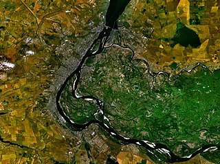
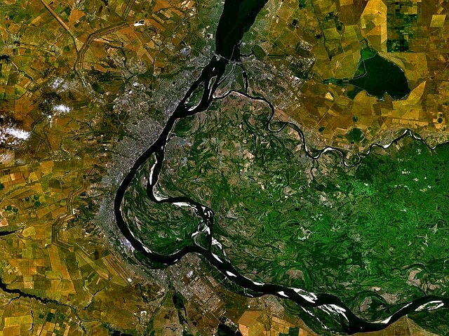
English: Volgograd, Russia |
| تریخ | ۱۹ مئی ۲۰۰۵ (upload date) |
| سروت | Satellite imagery taken from NASA World Wind software (by screenshot) |
| لکھاری | NASA |
| Object location | | View this and other nearby images on: OpenStreetMap |
|---|
لائسنس –
| This image is in the public domain because it is a screenshot from NASA’s globe software World Wind using a public domain layer, such as Blue Marble, MODIS, Landsat, SRTM, USGS or GLOBE.
|
 |
فائل دی تریخ
فائل نو اس ویلے دی حالت وچ ویکھن واسطے تاریخ/ویلے تے کلک کرو۔
| تریخ تے ویلہ | نکی مورت | پاسے | ورتن والا | تیپّݨی کرو | |
|---|---|---|---|---|---|
| موجودہ | ۲۳:۴۴, ۱۹ مئی ۲۰۰۵ | | ۱,۲۸۰ × ۹۵۸ (۲۶۲ کلوبائٹ) | Rex | Volgograd, Russia {{World Wind}} Category:Maps of Russia |
فائل دی ورتوں
تھلے دتے گئے 1 صفحے اس فائل نال جُڑدے نیں
فائل ویاپک ورتوں
ایہہ دوجے وکیاں ایس فائل نوں ورتدے نیں –
- ar.wikipedia.org تے ورتوں
- as.wikipedia.org تے ورتوں
- bh.wikipedia.org تے ورتوں
- bn.wikipedia.org تے ورتوں
- cy.wikipedia.org تے ورتوں
- el.wikipedia.org تے ورتوں
- en.wikipedia.org تے ورتوں
- et.wikipedia.org تے ورتوں
- fr.wikipedia.org تے ورتوں
- ha.wikipedia.org تے ورتوں
- he.wikipedia.org تے ورتوں
- hr.wikipedia.org تے ورتوں
- lad.wikipedia.org تے ورتوں
- nl.wikipedia.org تے ورتوں
- no.wikipedia.org تے ورتوں
- pa.wikipedia.org تے ورتوں
- sh.wikipedia.org تے ورتوں
- simple.wikipedia.org تے ورتوں
- sl.wikipedia.org تے ورتوں
- sv.wikipedia.org تے ورتوں
- ta.wikipedia.org تے ورتوں
- tl.wikipedia.org تے ورتوں
- ur.wikipedia.org تے ورتوں
- zh.wikipedia.org تے ورتوں