فائل:Volga.A2002137.0745.250m.jpg

ایس وکھالے دا ناپ: ۴۶۰ × ۶۰۰ پکسلز۔ دوجے ریزولوشنز: ۱۸۴ × ۲۴۰ پکسلز | ۳۶۸ × ۴۸۰ پکسلز | ۵۸۹ × ۷۶۸ پکسلز | ۷۸۵ × ۱,۰۲۴ پکسلز | ۱,۵۷۰ × ۲,۰۴۸ پکسلز | ۴,۶۰۰ × ۶,۰۰۰ پکسلز ۔
اصل فائل (۴,۶۰۰ × ۶,۰۰۰ پکسلز, فائل حجم: ۳.۹۱ میگابائٹ, MIME type: image/jpeg)
http://visibleearth.nasa.gov/view_rec.php?id=3823
Credit: Jacques Descloitres, MODIS Land Rapid Response Team, NASA/GSFC
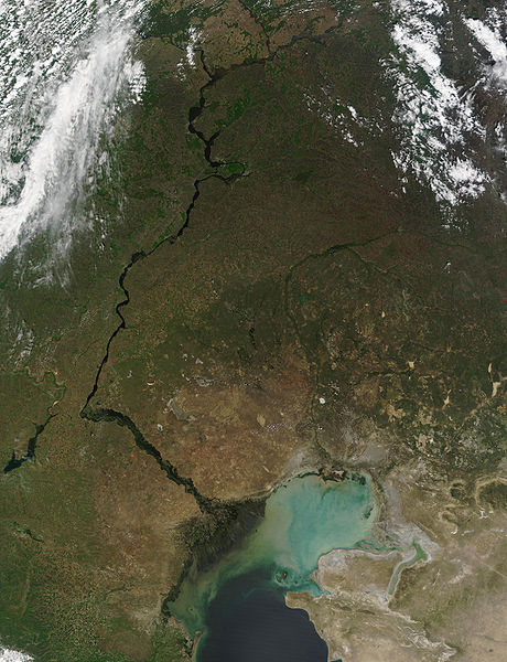
This MODIS image from May 17, 2002, shows the Volga River running north-south and emptying into the Caspian Sea. At lower left, extensive cultivation of the land can be seen in the regular patterns of fields. The light-colored waters of the Caspian Sea may be due to high sediment in the rivers that flow into it, as well as pollution and aquatic plant growth.
Metadata
- Sensor: Terra/MODIS
- Datastart: 2002-05-17
- Dataend: 2002-05-17
- Visible Earth v1 ID 19787
- Visualization Date: 2002-05-24
1. All Sensors 2. » MODIS
| This file is in the public domain in the United States because it was solely created by NASA. NASA copyright policy states that "NASA material is not protected by copyright unless noted". (See Template:PD-USGov, NASA copyright policy page or JPL Image Use Policy.) | ||
 |
Warnings:
|
فائل دی تریخ
فائل نو اس ویلے دی حالت وچ ویکھن واسطے تاریخ/ویلے تے کلک کرو۔
| تریخ تے ویلہ | نکی مورت | پاسے | ورتن والا | تیپّݨی کرو | |
|---|---|---|---|---|---|
| موجودہ | ۰۲:۳۸, ۲۶ اگست ۲۰۰۵ | | ۴,۶۰۰ × ۶,۰۰۰ (۳.۹۱ میگابائٹ) | Nanosmile | http://visibleearth.nasa.gov/view_rec.php?id=3823 Credit: Jacques Descloitres, MODIS Land Rapid Response Team, NASA/GSFC This MODIS image from May 17, 2002, shows the Volga River running north-south and emptying into the Caspian Sea. At lower left, exte |
فائل دی ورتوں
تھلے دتے گئے 1 صفحے اس فائل نال جُڑدے نیں
فائل ویاپک ورتوں
ایہہ دوجے وکیاں ایس فائل نوں ورتدے نیں –
- ar.wikipedia.org تے ورتوں
- as.wikipedia.org تے ورتوں
- av.wikipedia.org تے ورتوں
- bg.wikipedia.org تے ورتوں
- bh.wikipedia.org تے ورتوں
- bn.wikipedia.org تے ورتوں
- ca.wikipedia.org تے ورتوں
- cv.wikipedia.org تے ورتوں
- cy.wikipedia.org تے ورتوں
- el.wikipedia.org تے ورتوں
- en.wikipedia.org تے ورتوں
- es.wikipedia.org تے ورتوں
- gl.wikipedia.org تے ورتوں
- it.wikipedia.org تے ورتوں
- lad.wikipedia.org تے ورتوں
- no.wikipedia.org تے ورتوں
- pa.wikipedia.org تے ورتوں
- ro.wikipedia.org تے ورتوں
- sl.wikipedia.org تے ورتوں
- tl.wikipedia.org تے ورتوں
- tr.wikipedia.org تے ورتوں
- uk.wikipedia.org تے ورتوں
- ur.wikipedia.org تے ورتوں